TopoQuest Logo
Do you find TopoQuest useful?
Help keep TopoQuest running and adding new maps/features by donating!
Bitcoin:  19c7KJd3qBynnjoSw5npx9KScwjBe4ifkT
Litecoin:  LXs6TkuXGGXo1vDsWCkWVdjQX94eUKd6ui
Home View Maps Find Maps Find Places Resources & Links


Nettie, West Virginia Topographic Map

USGS Map Title: Nettie, WV
USGS Map MRC: 38080B6
DRG (GeoTIFF) Download: o38080b6.tif


Neighboring USGS Topographic Map Quads:


  Summersville, WV  
38080C7
 

  Craigsville, WV  
38080C6
 

  Camden On Gauley, WV  
38080C5
 

  Mount Nebo, WV  
38080B7
 

  Nettie, WV  
38080B6
 

  Richwood, WV  
38080B5
 

  Corliss, WV  
38080A7
 

  Quinwood, WV  
38080A6
 

  Duo, WV  
38080A5


Map MRC Location:

N39°
W81°
N39°
W80°
H8 H7 H6 H5 H4 H3 H2 H1
G8 G7 G6 G5 G4 G3 G2 G1
F8 F7 F6 F5 F4 F3 F2 F1
E8 E7 E6 E5 E4 E3 E2 E1
D8 D7 D6 D5 D4 D3 D2 D1
C8 C7 C6 C5 C4 C3 C2 C1
B8 B7 B6 B5 B4 B3 B2 B1
A8 A7 A6 A5 A4 A3 A2 A1
N38°
W81°
N38°
W80°

Nettie, WV USGS 1:24K Topographic Map Preview:
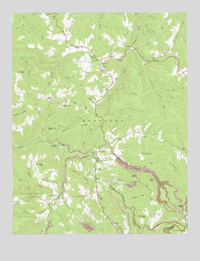
Nettie, WV USGS Topographic Map
Click on map above to begin viewing in our Map Viewer.

This topographic map contains these locations and features:
Feature Name Type Latitude Longitude GNIS ID View Map
Barn RidgeRidgeN38.1976°W80.7465°1550170View Map
Beckley ChapelChurchN38.2018°W80.7218°1550232View Map
Beech KnobSummitN38.1579°W80.6648°1553837View Map
Bowen RunStreamN38.1704°W80.7026°1550433View Map
Brushy Meadow CreekStreamN38.1709°W80.7112°1550509View Map
Chestnut Lick RunStreamN38.1668°W80.6731°1550695View Map
Clements DivideRidgeN38.1862°W80.7448°1557075View Map
Conn RunStreamN38.2382°W80.6598°1550781View Map
Cranes Nest RunStreamN38.2071°W80.6415°1550827View Map
Davis RidgeRidgeN38.1837°W80.7048°1550880View Map
Dawson School (historical)SchoolN38.2434°W80.6690°1557077View Map
Downtain ChapelChurchN38.2304°W80.7015°1550949View Map
Downtain Chapel CemeteryCemeteryN38.2307°W80.7012°1741160View Map
Eureka ChurchChurchN38.1723°W80.6262°1551068View Map
Fairview CemeteryCemeteryN38.2126°W80.6776°1538799View Map
Fields CemeteryCemeteryN38.1996°W80.6906°1551102View Map
Fury KnobSummitN38.2168°W80.7440°1554519View Map
Geho RunStreamN38.2440°W80.6581°1551217View Map
Grassy CreekStreamN38.1693°W80.6918°1551272View Map
Grassy Creek School (historical)SchoolN38.1787°W80.6715°1557081View Map
Grassy FallsPopulated PlaceN38.1726°W80.6876°1554595View Map
Grassy RidgeRidgeN38.1712°W80.6404°1551275View Map
Holcomb RunStreamN38.2479°W80.6595°1551474View Map
Hominy FallsPopulated PlaceN38.1454°W80.7187°1551482View Map
Hughey DivideGapN38.1404°W80.6281°1551519View Map
Hurricane RidgeRidgeN38.1571°W80.7006°1551534View Map
Jims BranchStreamN38.2301°W80.6656°1551574View Map
Kentucky DistrictCivilN38.2109°W80.6889°1928296View Map
Laurel KnobSummitN38.1554°W80.6526°1554918View Map
LeivasyPopulated PlaceN38.1612°W80.6909°1554940View Map
Leivasy Elementary School (historical)SchoolN38.1673°W80.6912°1741181View Map
Leivasy Post OfficePost OfficeN38.1611°W80.6905°1741182View Map
Lick RunStreamN38.2482°W80.7412°1551794View Map
Line Laurel CreekStreamN38.1743°W80.6815°1551821View Map
LowlandLocaleN38.2312°W80.6656°1551965View Map
Mayflower School (historical)SchoolN38.2343°W80.7156°1557086View Map
Middle RidgeRidgeN38.1532°W80.7362°1552080View Map
Mount Zion ChurchChurchN38.2232°W80.6881°1552221View Map
NettiePopulated PlaceN38.2184°W80.6859°1552290View Map
Nettie Census Designated PlaceCensusN38.2183°W80.6889°2586858View Map
Nettie Elementary School (historical)SchoolN38.2190°W80.6876°1741196View Map
Nettie Post OfficePost OfficeN38.2243°W80.6860°1741197View Map
Nettie Volunteer Fire DepartmentBuildingN38.2193°W80.6879°2578036View Map
Nettle RunStreamN38.2079°W80.6479°1552291View Map
New Prospect ChurchChurchN38.1665°W80.6870°1552300View Map
New Testament Baptist ChurchChurchN38.1909°W80.6873°1741199View Map
North RunStreamN38.2221°W80.6570°1552346View Map
Odell School (historical)SchoolN38.2009°W80.7312°1557093View Map
Odell Spring BranchStreamN38.2265°W80.7470°1552366View Map
Odell TownPopulated PlaceN38.1979°W80.7134°1552367View Map
Olive Branch CemeteryCemeteryN38.2209°W80.6862°1741205View Map
Olive Branch ChurchChurchN38.2209°W80.6856°1552387View Map
Ophelia (historical)Populated PlaceN38.2093°W80.7198°1557094View Map
Packlets CreekStreamN38.1543°W80.7156°1552406View Map
Panther Creek Elementary SchoolSchoolN38.2289°W80.7055°2088302View Map
Penile CemeteryCemeteryN38.1434°W80.7168°1741210View Map
Penile ChurchChurchN38.1432°W80.7181°1552453View Map
Potato Hole KnobSummitN38.1846°W80.7243°1555398View Map
Quinwood Emergency Ambulance Service NettieBuildingN38.2230°W80.6858°2581150View Map
Riley BranchStreamN38.2201°W80.7215°1552666View Map
Roaring CreekStreamN38.1476°W80.7156°1552684View Map
Rocky RidgeRidgeN38.1457°W80.6593°1552715View Map
Short Back HillSummitN38.1646°W80.7270°1555617View Map
Skelt RunStreamN38.2448°W80.7420°1552908View Map
Sugar BranchStreamN38.1407°W80.7234°1553109View Map
Thorny KnobSummitN38.2284°W80.6373°1555806View Map
Thorny Knob School (historical)SchoolN38.2351°W80.6348°1557102View Map
TolbertPopulated PlaceN38.1968°W80.6909°1557103View Map
Tolbert School (historical)SchoolN38.2043°W80.6837°1557104View Map
Trout Valley School (historical)SchoolN38.1368°W80.7048°1557105View Map
Wahoo School (historical)SchoolN38.1607°W80.7318°1557107View Map
White Buck KnobSummitN38.1348°W80.6551°1555967View Map
White Buck School (historical)SchoolN38.1262°W80.6576°1557108View Map

Note: Coordinates in the location and feature list above are referenced to NAD83 datum.


Copyright (C) 2008-2025 Ryan Niemi / Sunset Dynamics ... All Rights Reserved