TopoQuest Logo
Do you find TopoQuest useful?
Help keep TopoQuest running and adding new maps/features by donating!
Bitcoin:  19c7KJd3qBynnjoSw5npx9KScwjBe4ifkT
Litecoin:  LXs6TkuXGGXo1vDsWCkWVdjQX94eUKd6ui
Home View Maps Find Maps Find Places Resources & Links


Mount Nebo, West Virginia Topographic Map

USGS Map Title: Mount Nebo, WV
USGS Map MRC: 38080B7
DRG (GeoTIFF) Download: o38080b7.tif


Neighboring USGS Topographic Map Quads:


  Gilboa, WV  
38080C8
 

  Summersville, WV  
38080C7
 

  Craigsville, WV  
38080C6
 

  Summersville Dam, WV  
38080B8
 

  Mount Nebo, WV  
38080B7
 

  Nettie, WV  
38080B6
 

  Winona, WV  
38080A8
 

  Corliss, WV  
38080A7
 

  Quinwood, WV  
38080A6


Map MRC Location:

N39°
W81°
N39°
W80°
H8 H7 H6 H5 H4 H3 H2 H1
G8 G7 G6 G5 G4 G3 G2 G1
F8 F7 F6 F5 F4 F3 F2 F1
E8 E7 E6 E5 E4 E3 E2 E1
D8 D7 D6 D5 D4 D3 D2 D1
C8 C7 C6 C5 C4 C3 C2 C1
B8 B7 B6 B5 B4 B3 B2 B1
A8 A7 A6 A5 A4 A3 A2 A1
N38°
W81°
N38°
W80°

Mount Nebo, WV USGS 1:24K Topographic Map Preview:
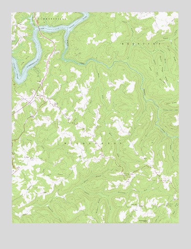
Mount Nebo, WV USGS Topographic Map
Click on map above to begin viewing in our Map Viewer.

This topographic map contains these locations and features:
Feature Name Type Latitude Longitude GNIS ID View Map
Bean School (historical)SchoolN38.1954°W80.8012°1557067View Map
Belmont School (historical)SchoolN38.2373°W80.8698°1557069View Map
Blacks Chapel (historical)ChurchN38.2190°W80.8487°1741140View Map
Blacks Chapel School (historical)SchoolN38.2190°W80.8490°1557070View Map
BrucePopulated PlaceN38.1632°W80.7768°1553997View Map
Bryant RidgeRidgeN38.2190°W80.7629°1536537View Map
Bryant RunStreamN38.2254°W80.7701°1536538View Map
Bryant School (historical)SchoolN38.2493°W80.7679°1557071View Map
Buckhorn CemeteryCemeteryN38.1357°W80.7801°1741142View Map
Buckhorn School (historical)SchoolN38.1346°W80.7793°1557072View Map
Buckhorn United Methodist ChurchChurchN38.1351°W80.7804°1536599View Map
Chestnut Camp RunStreamN38.1915°W80.7656°1550689View Map
Daubenspeck KnobSummitN38.1262°W80.7729°1554259View Map
DeepwellPopulated PlaceN38.2343°W80.7565°1554280View Map
Deer CreekStreamN38.2201°W80.7890°1550899View Map
Dixon Chapel CemeteryCemeteryN38.1782°W80.7868°1741158View Map
Dixon Chapel United Methodist ChurchChurchN38.1782°W80.7868°1538216View Map
Dorsey BranchStreamN38.1471°W80.8251°1538275View Map
Elevenmile ForkStreamN38.1412°W80.8043°1538591View Map
Fleger Ridge School (historical)SchoolN38.1390°W80.7545°1539075View Map
Fowler KnobSummitN38.1951°W80.8434°1539197View Map
Fowler KnobPopulated PlaceN38.1840°W80.8123°1557079View Map
Fowler Knob ChurchChurchN38.1990°W80.8476°1539198View Map
Fowlers Knob CemeteryCemeteryN38.1990°W80.8479°1741167View Map
Gilgal CemeteryCemeteryN38.1893°W80.8354°1741169View Map
Gilgal School (historical)SchoolN38.1882°W80.8312°1557080View Map
Gilgal United Methodist ChurchChurchN38.1896°W80.8359°1539396View Map
Groves Spring BranchStreamN38.2279°W80.7665°1539775View Map
Hickory Grove CemeteryCemeteryN38.1812°W80.8120°1741172View Map
Hickory Grove United Methodist ChurchChurchN38.1818°W80.8129°1540214View Map
Hominy CreekStreamN38.2398°W80.8332°1551481View Map
Hughes BridgeBridgeN38.2403°W80.8545°2647548View Map
Hughes Ferry Bridge (historical)BridgeN38.2404°W80.8537°1557083View Map
Jerry ForkStreamN38.2084°W80.8109°1540873View Map
Jims CreekStreamN38.2334°W80.7565°1551575View Map
Jims RidgeRidgeN38.2248°W80.7545°1540912View Map
Laurel BranchStreamN38.2301°W80.7848°1541394View Map
Long PointCapeN38.2204°W80.8648°1542393View Map
McMillon School (historical)SchoolN38.1759°W80.8301°1557087View Map
Middle Branch Hominy CreekStreamN38.1757°W80.7543°1552060View Map
Mount Gilead CemeteryCemeteryN38.1626°W80.8604°1741189View Map
Mount Gilead ChurchChurchN38.1629°W80.8609°1543641View Map
Mount Lookout Elementary SchoolSchoolN38.1563°W80.8737°2088281View Map
Mount NeboPopulated PlaceN38.2001°W80.8512°1555172View Map
Mount Nebo Elementary SchoolSchoolN38.2086°W80.8535°1543690View Map
Mount Nebo Post OfficePost OfficeN38.1998°W80.8528°1741192View Map
Mouse ForkStreamN38.2207°W80.8104°1543889View Map
Murphy BranchStreamN38.1426°W80.8109°1544007View Map
Oak Hill School (historical)SchoolN38.2096°W80.8279°1557092View Map
Pleasant Hill CemeteryCemeteryN38.1426°W80.8551°1741216View Map
Pleasant Hill United Methodist ChurchChurchN38.1423°W80.8554°1741217View Map
PoolPopulated PlaceN38.1637°W80.8643°1555391View Map
Rocky Point School (historical)SchoolN38.1548°W80.8659°1557096View Map
RunaPopulated PlaceN38.1429°W80.8512°1555539View Map
Runa Post OfficePost OfficeN38.1426°W80.8479°1741221View Map
Salmon RunStreamN38.2407°W80.8570°1546300View Map
Snow HillPopulated PlaceN38.1354°W80.7815°1555655View Map
Snow Hill ChurchChurchN38.1362°W80.7595°1547039View Map
Spruce Grove CemeteryCemeteryN38.1540°W80.7865°1741227View Map
Spruce Grove School (historical)SchoolN38.1543°W80.7815°1557100View Map
Spruce Grove United Methodist ChurchChurchN38.1537°W80.7868°1547250View Map
Sugargrove CreekStreamN38.1365°W80.8490°1547697View Map
Summersville AirportAirportN38.2328°W80.8683°1558849View Map
Summersville LakeReservoirN38.2434°W80.8598°1553142View Map
The BendBendN38.2440°W80.7562°1547997View Map
The DivideRidgeN38.2137°W80.7701°1548001View Map
Trent BranchStreamN38.1543°W80.8523°1548261View Map
Wilderness DistrictCivilN38.1548°W80.8213°1928418View Map

Note: Coordinates in the location and feature list above are referenced to NAD83 datum.


Copyright (C) 2008-2025 Ryan Niemi / Sunset Dynamics ... All Rights Reserved