TopoQuest Logo
Do you find TopoQuest useful?
Help keep TopoQuest running and adding new maps/features by donating!
Bitcoin:  19c7KJd3qBynnjoSw5npx9KScwjBe4ifkT
Litecoin:  LXs6TkuXGGXo1vDsWCkWVdjQX94eUKd6ui
Home View Maps Find Maps Find Places Resources & Links


Corliss, West Virginia Topographic Map

USGS Map Title: Corliss, WV
USGS Map MRC: 38080A7
DRG (GeoTIFF) Download: o38080a7.tif


Neighboring USGS Topographic Map Quads:


  Summersville Dam, WV  
38080B8
 

  Mount Nebo, WV  
38080B7
 

  Nettie, WV  
38080B6
 

  Winona, WV  
38080A8
 

  Corliss, WV  
38080A7
 

  Quinwood, WV  
38080A6
 

  Danese, WV  
37080H8
 

  Rainelle, WV  
37080H7
 

  Rupert, WV  
37080H6


Map MRC Location:

N39°
W81°
N39°
W80°
H8 H7 H6 H5 H4 H3 H2 H1
G8 G7 G6 G5 G4 G3 G2 G1
F8 F7 F6 F5 F4 F3 F2 F1
E8 E7 E6 E5 E4 E3 E2 E1
D8 D7 D6 D5 D4 D3 D2 D1
C8 C7 C6 C5 C4 C3 C2 C1
B8 B7 B6 B5 B4 B3 B2 B1
A8 A7 A6 A5 A4 A3 A2 A1
N38°
W81°
N38°
W80°

Corliss, WV USGS 1:24K Topographic Map Preview:
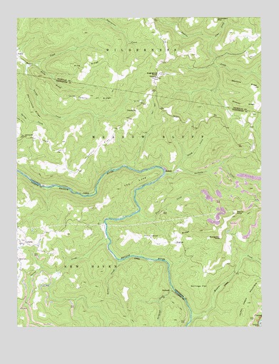
Corliss, WV USGS Topographic Map
Click on map above to begin viewing in our Map Viewer.

This topographic map contains these locations and features:
Feature Name Type Latitude Longitude GNIS ID View Map
Beargarden KnobSummitN38.0362°W80.7712°1553821View Map
Bearhole RidgeRidgeN38.0973°W80.7581°1535414View Map
BinghamPopulated PlaceN38.0337°W80.7937°1553905View Map
BurdettePopulated PlaceN38.0632°W80.7995°1554029View Map
Burdette CreekStreamN38.0621°W80.7998°1550559View Map
Cemetery Hill ChurchChurchN38.0771°W80.8712°1537148View Map
Corlis School (historical)SchoolN38.0268°W80.8740°1556069View Map
CorlissPopulated PlaceN38.0343°W80.8701°1554193View Map
Forest View School (historical)SchoolN38.0823°W80.7579°1556429View Map
Germany School (historical)SchoolN38.0734°W80.7537°1556432View Map
Hickory FlatFlatN38.0723°W80.8334°1540207View Map
Honeydew (historical)Populated PlaceN38.0346°W80.8298°1556122View Map
Hurricane RidgeRidgeN38.0343°W80.7973°1540631View Map
Hurricane Ridge School (historical)SchoolN38.0382°W80.7948°1556437View Map
Jims CreekStreamN38.1168°W80.7748°1540910View Map
Kates CreekStreamN38.0271°W80.8229°1541083View Map
Keester RidgeRidgeN38.0923°W80.8354°1541108View Map
Laurel CreekStreamN38.0362°W80.8287°1541417View Map
Loop School (historical)SchoolN38.0432°W80.8468°1556140View Map
Meadow CreekStreamN38.0037°W80.7859°1552046View Map
Miller CreekStreamN38.1065°W80.8701°1543380View Map
Minnie Belle Baptist ChurchChurchN38.0271°W80.8743°1543443View Map
New Prospect School (historical)SchoolN38.0754°W80.8607°1556449View Map
North Prong Miller CreekStreamN38.1062°W80.8662°1544233View Map
Nutter School (historical)SchoolN38.0837°W80.7934°1556450View Map
NuttervillePopulated PlaceN38.0876°W80.8140°1555249View Map
Nutterville School (historical)SchoolN38.0801°W80.8237°1556451View Map
Pine RidgeRidgeN38.1037°W80.8382°1544897View Map
Piney CreekStreamN38.0637°W80.7931°1544918View Map
Rader FordCrossingN38.0382°W80.8295°1556184View Map
Rider CemeteryCemeteryN38.0334°W80.8688°2574007View Map
Shawver RidgeRidgeN38.0898°W80.7581°1546649View Map
Shillings FlatFlatN38.0168°W80.7820°1546681View Map
Sugar Grove Lookout TowerLocaleN38.1023°W80.8020°1741260View Map
Sugar Grove United Methodist ChurchChurchN38.1009°W80.8029°1547696View Map
Sugar Grove United Methodist Church CemeteryCemeteryN38.1009°W80.8029°1741259View Map
Sugargrove KnobSummitN38.1026°W80.8020°1547698View Map
Sugargrove School (historical)SchoolN38.1104°W80.8073°1557101View Map
SurbaughPopulated PlaceN38.0146°W80.7954°1555760View Map
Surbaugh CreekStreamN38.0157°W80.7954°1547771View Map
The LoopBendN38.0590°W80.8148°1548007View Map
Toms CreekStreamN38.0468°W80.8123°1548136View Map
Wallowhole RidgeRidgeN38.0876°W80.8668°1548744View Map
Walnut KnobSummitN38.0459°W80.7631°1548773View Map

Note: Coordinates in the location and feature list above are referenced to NAD83 datum.


Copyright (C) 2008-2025 Ryan Niemi / Sunset Dynamics ... All Rights Reserved