TopoQuest Logo
Do you find TopoQuest useful?
Help keep TopoQuest running and adding new maps/features by donating!
Bitcoin:  19c7KJd3qBynnjoSw5npx9KScwjBe4ifkT
Litecoin:  LXs6TkuXGGXo1vDsWCkWVdjQX94eUKd6ui
Home View Maps Find Maps Find Places Resources & Links


Richwood, West Virginia Topographic Map

USGS Map Title: Richwood, WV
USGS Map MRC: 38080B5
DRG (GeoTIFF) Download: o38080b5.tif


Neighboring USGS Topographic Map Quads:


  Craigsville, WV  
38080C6
 

  Camden On Gauley, WV  
38080C5
 

  Webster Springs SW, WV  
38080C4
 

  Nettie, WV  
38080B6
 

  Richwood, WV  
38080B5
 

  Fork Mountain, WV  
38080B4
 

  Quinwood, WV  
38080A6
 

  Duo, WV  
38080A5
 

  Trout, WV  
38080A4


Map MRC Location:

N39°
W81°
N39°
W80°
H8 H7 H6 H5 H4 H3 H2 H1
G8 G7 G6 G5 G4 G3 G2 G1
F8 F7 F6 F5 F4 F3 F2 F1
E8 E7 E6 E5 E4 E3 E2 E1
D8 D7 D6 D5 D4 D3 D2 D1
C8 C7 C6 C5 C4 C3 C2 C1
B8 B7 B6 B5 B4 B3 B2 B1
A8 A7 A6 A5 A4 A3 A2 A1
N38°
W81°
N38°
W80°

Richwood, WV USGS 1:24K Topographic Map Preview:
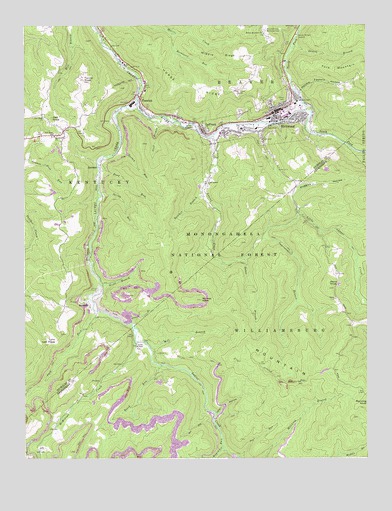
Richwood, WV USGS Topographic Map
Click on map above to begin viewing in our Map Viewer.

This topographic map contains these locations and features:
Feature Name Type Latitude Longitude GNIS ID View Map
Baber BranchStreamN38.1826°W80.5445°1550128View Map
Baber CemeteryCemeteryN38.1712°W80.5112°1550129View Map
Bear RunStreamN38.1257°W80.5473°1550189View Map
Beech RunStreamN38.1518°W80.5759°1550250View Map
Big MountainSummitN38.1504°W80.5209°1553898View Map
Buckheart RunStreamN38.2479°W80.5709°1550534View Map
Butcher BranchStreamN38.2037°W80.5587°1550572View Map
Cherry River Elementary SchoolSchoolN38.2190°W80.5533°1741241View Map
Church of GodChurchN38.2159°W80.5548°1741242View Map
City of RichwoodCivilN38.2221°W80.5363°2390643View Map
Dad KnobSummitN38.2234°W80.6148°1554250View Map
Desert BranchStreamN38.2421°W80.5281°1550906View Map
Fallbrook School (historical)SchoolN38.1415°W80.6068°1556281View Map
FenwickPopulated PlaceN38.2287°W80.5823°1554450View Map
Fenwick Census Designated PlaceCensusN38.2288°W80.5804°2586804View Map
Fenwick Post OfficePost OfficeN38.2300°W80.5828°1741164View Map
First Baptist Church of RichwoodChurchN38.2259°W80.5329°1741244View Map
First Church of GodChurchN38.2232°W80.5323°1741245View Map
First United Methodist ChurchChurchN38.2254°W80.5334°1741246View Map
Fork MountainSummitN38.2393°W80.5018°1551157View Map
Fork Mountain School (historical)SchoolN38.2343°W80.5045°1557078View Map
Garrett Bragg Memorial BridgeBridgeN38.2294°W80.5832°2647551View Map
Gauley Ranger StationLocaleN38.2473°W80.5254°1551215View Map
Handle Factory HollowValleyN38.2312°W80.5234°1551347View Map
Hinkle Mountain CemeteryCemeteryN38.2473°W80.5376°1741247View Map
Hinkle Mountain United Methodist ChurchChurchN38.2476°W80.5370°1540315View Map
Hogcamp RunStreamN38.1309°W80.5531°1551467View Map
Holy Family Catholic ChurchChurchN38.2215°W80.5326°1741248View Map
Horse RidgeRidgeN38.2326°W80.5656°1551495View Map
Horse Ridge School (historical)SchoolN38.2384°W80.5404°1557082View Map
Huggins HollowValleyN38.1971°W80.5251°1551515View Map
Improvement BranchStreamN38.1884°W80.5393°1551541View Map
Jets HollowValleyN38.1379°W80.5548°1551571View Map
JetsvillePopulated PlaceN38.1690°W80.6009°1554808View Map
Jim Comstock Memorial BridgeBridgeN38.2208°W80.5524°2647550View Map
Kerless KnobSummitN38.1709°W80.5606°1551638View Map
LaFrankPopulated PlaceN38.2187°W80.5590°1554899View Map
LaFrank United Methodist ChurchChurchN38.2190°W80.5584°1741249View Map
Laurel CreekStreamN38.2265°W80.5837°1551705View Map
LilePopulated PlaceN38.1271°W80.6198°1551804View Map
Little Laurel ChurchChurchN38.2046°W80.5587°1551862View Map
Little Laurel CreekStreamN38.2179°W80.5565°1551865View Map
Little Laurel School (historical)SchoolN38.2046°W80.5590°1557084View Map
Little Mountain School (historical)SchoolN38.2082°W80.5318°1557085View Map
Lynn Low PlaceGapN38.1584°W80.6148°1551977View Map
Macedonia ChurchChurchN38.2182°W80.6126°1551980View Map
Mann KnobSummitN38.1757°W80.5137°1555037View Map
McMillion CreekStreamN38.1587°W80.5843°1552041View Map
Middle RidgeRidgeN38.2412°W80.5537°1552081View Map
Mill BranchStreamN38.1587°W80.5812°1552096View Map
Milltown SchoolSchoolN38.2282°W80.5248°1552158View Map
Mount Hope School (historical)SchoolN38.2290°W80.6162°1557089View Map
Mountain View Memorial ParkCemeteryN38.2482°W80.5365°1552241View Map
Namo ChapelChurchN38.1576°W80.5840°1552271View Map
New Hope CemeteryCemeteryN38.2187°W80.6201°1741251View Map
New Hope ChurchChurchN38.2240°W80.6181°1552297View Map
New Hope School (historical)SchoolN38.2184°W80.6140°1552299View Map
Nixon BranchStreamN38.1754°W80.5973°1552311View Map
Nixon School (historical)SchoolN38.1718°W80.6187°1557090View Map
North Fork Cherry RiverStreamN38.2257°W80.5220°1552327View Map
Pack ForkStreamN38.1676°W80.5993°1552405View Map
Piney BranchStreamN38.1643°W80.5865°1552489View Map
Redi Care Incorporated Station 2BuildingN38.2201°W80.5455°2581118View Map
RichwoodPopulated PlaceN38.2248°W80.5331°1555475View Map
Richwood Area Community HospitalHospitalN38.2202°W80.5455°1741252View Map
Richwood CemeteryCemeteryN38.2251°W80.5462°1741253View Map
Richwood Christian ChurchChurchN38.2226°W80.5343°1741254View Map
Richwood High SchoolSchoolN38.2233°W80.5294°1741257View Map
Richwood Middle SchoolSchoolN38.2245°W80.5278°1741255View Map
Richwood Police DepartmentBuildingN38.2252°W80.5300°2728116View Map
Richwood Post OfficePost OfficeN38.2253°W80.5322°1741219View Map
Richwood Presbyterian ChurchChurchN38.2262°W80.5293°1741256View Map
Richwood Public LibraryBuildingN38.2250°W80.5298°2727359View Map
Richwood Volunteer Fire DepartmentBuildingN38.2244°W80.5307°2577526View Map
Riverside Baptist ChurchChurchN38.2179°W80.5534°1741258View Map
Road RunStreamN38.2112°W80.5973°1552679View Map
SaxmanPopulated PlaceN38.2098°W80.5970°1555577View Map
South Fork Cherry RiverStreamN38.2257°W80.5220°1552973View Map
Spencer RunStreamN38.2298°W80.5234°1557099View Map
Spring RunStreamN38.2007°W80.5965°1547205View Map
Staff BranchStreamN38.2234°W80.5793°1553036View Map
Tanner KnobSummitN38.2343°W80.6031°1553174View Map
Turkey RunStreamN38.2140°W80.5904°1553288View Map
View School (historical)SchoolN38.1593°W80.5051°1556379View Map
West Virginia State Police Troop 6 - Richwood DetachmentBuildingN38.2243°W80.5308°2728115View Map
WVAR Radio Tower (Sturgeon Bay)TowerN38.2304°W80.5468°1560606View Map
WVAR-AM (Richwood)TowerN38.2307°W80.5468°1559741View Map

Note: Coordinates in the location and feature list above are referenced to NAD83 datum.


Copyright (C) 2008-2024 Ryan Niemi / Sunset Dynamics ... All Rights Reserved