TopoQuest Logo
Do you find TopoQuest useful?
Help keep TopoQuest running and adding new maps/features by donating!
Bitcoin:  19c7KJd3qBynnjoSw5npx9KScwjBe4ifkT
Litecoin:  LXs6TkuXGGXo1vDsWCkWVdjQX94eUKd6ui
Home View Maps Find Maps Find Places Resources & Links


Craigsville, West Virginia Topographic Map

USGS Map Title: Craigsville, WV
USGS Map MRC: 38080C6
DRG (GeoTIFF) Download: o38080c6.tif


Neighboring USGS Topographic Map Quads:


  Widen, WV  
38080D7
 

  Tioga, WV  
38080D6
 

  Cowen, WV  
38080D5
 

  Summersville, WV  
38080C7
 

  Craigsville, WV  
38080C6
 

  Camden On Gauley, WV  
38080C5
 

  Mount Nebo, WV  
38080B7
 

  Nettie, WV  
38080B6
 

  Richwood, WV  
38080B5


Map MRC Location:

N39°
W81°
N39°
W80°
H8 H7 H6 H5 H4 H3 H2 H1
G8 G7 G6 G5 G4 G3 G2 G1
F8 F7 F6 F5 F4 F3 F2 F1
E8 E7 E6 E5 E4 E3 E2 E1
D8 D7 D6 D5 D4 D3 D2 D1
C8 C7 C6 C5 C4 C3 C2 C1
B8 B7 B6 B5 B4 B3 B2 B1
A8 A7 A6 A5 A4 A3 A2 A1
N38°
W81°
N38°
W80°

Craigsville, WV USGS 1:24K Topographic Map Preview:
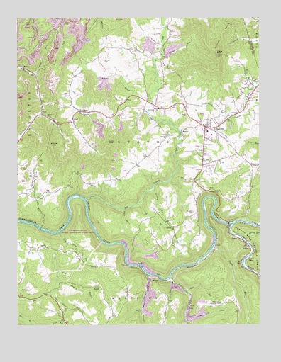
Craigsville, WV USGS Topographic Map
Click on map above to begin viewing in our Map Viewer.

This topographic map contains these locations and features:
Feature Name Type Latitude Longitude GNIS ID View Map
Adkins Lick CreekStreamN38.2543°W80.6634°1550078View Map
Alderson ChurchChurchN38.3268°W80.6734°1550085View Map
Back ForkStreamN38.3521°W80.7409°1550135View Map
Barn RunStreamN38.3482°W80.6279°1550171View Map
Bear RunStreamN38.2632°W80.6626°1550191View Map
BeaverPopulated PlaceN38.3284°W80.6654°1553827View Map
Beaver Elementary SchoolSchoolN38.3380°W80.6769°1550227View Map
Big Beaver CreekStreamN38.3012°W80.7143°1550282View Map
Big RunStreamN38.2998°W80.6881°1550315View Map
Brock RunStreamN38.2671°W80.6695°1550479View Map
Burnt KnobSummitN38.3243°W80.7031°1550567View Map
CalvinPopulated PlaceN38.3368°W80.7145°1550587View Map
Calvin ChapelChurchN38.3340°W80.7209°1550588View Map
Calvin ChurchChurchN38.3357°W80.7368°1550589View Map
Calvin Post OfficePost OfficeN38.3365°W80.7129°1741144View Map
Chapman School (historical)SchoolN38.2646°W80.6929°1741147View Map
Cherry RiverStreamN38.2904°W80.6404°1550686View Map
Cherry RunStreamN38.3346°W80.6390°1550687View Map
Chestnut Flat ChurchChurchN38.2898°W80.6693°1550691View Map
Coal SidingLocaleN38.2771°W80.6315°1550742View Map
Coal Siding RunStreamN38.2784°W80.6293°1550743View Map
CottlePopulated PlaceN38.3465°W80.6265°1554197View Map
Cottle Glade School (historical)SchoolN38.3468°W80.6268°1741148View Map
Cottle GladesFlatN38.3462°W80.6318°1550796View Map
Cottle KnobSummitN38.3604°W80.6470°1550797View Map
Cottle Knob Lookout TowerLocaleN38.3601°W80.6473°1741149View Map
Cottle Post OfficePost OfficeN38.3462°W80.6268°1741150View Map
CraigsvillePopulated PlaceN38.3307°W80.6531°1550820View Map
Craigsville - Beaver - Cottle Volunteer Fire DepartmentBuildingN38.3336°W80.6410°2578056View Map
Craigsville Census Designated PlaceCensusN38.3246°W80.6449°2389368View Map
Craigsville Church of GodChurchN38.3262°W80.6531°1741151View Map
Craigsville Elementary SchoolSchoolN38.3288°W80.6519°1741152View Map
Craigsville Post OfficePost OfficeN38.3250°W80.6542°1741153View Map
Craigsville Public LibraryBuildingN38.3285°W80.6525°2727357View Map
Craigsville Revival Center Pentecostal ChurchChurchN38.3290°W80.6493°1741154View Map
Crooked RunStreamN38.2896°W80.7376°1550842View Map
CurtinPopulated PlaceN38.2854°W80.6365°1554244View Map
Curtin BridgeBridgeN38.2910°W80.6413°2647555View Map
Curtin RunStreamN38.2862°W80.6351°1550864View Map
DonaldPopulated PlaceN38.2657°W80.7093°1549657View Map
Eller HollowValleyN38.3637°W80.6773°1551052View Map
First Baptist ChurchChurchN38.3315°W80.6540°1741165View Map
Granny RunStreamN38.3051°W80.6798°1551267View Map
Hannah RunStreamN38.3593°W80.6759°1551355View Map
Herold AirportAirportN38.3363°W80.6528°1558789View Map
Hickman School (historical)SchoolN38.3351°W80.7351°1551418View Map
Hicks School (historical)SchoolN38.3096°W80.6987°1741173View Map
Hinkle ChapelChurchN38.3082°W80.6579°1551455View Map
Hughey BranchStreamN38.2679°W80.7279°1551518View Map
Jan - Care Ambulance Service CraigsvilleBuildingN38.3230°W80.6546°2581094View Map
Lambert CemeteryCemeteryN38.3684°W80.6793°1551685View Map
Little Beaver CreekStreamN38.3382°W80.6823°1551831View Map
Little Laurel CreekStreamN38.2704°W80.6823°1551866View Map
Little RunStreamN38.2973°W80.6951°1551891View Map
Little Union CemeteryCemeteryN38.3443°W80.7237°1741183View Map
Little Union ChurchChurchN38.3359°W80.7154°1551903View Map
Locust Grove ChurchChurchN38.3143°W80.6251°1551912View Map
Low Place BranchStreamN38.2629°W80.7345°1551956View Map
MarybillPopulated PlaceN38.2687°W80.6823°1555061View Map
Mount Zion ChurchChurchN38.3059°W80.6293°1552223View Map
Mullens CemeteryCemeteryN38.3576°W80.7051°1552265View Map
Nicholas County Career and Technical CenterSchoolN38.3273°W80.6500°1741201View Map
NilePopulated PlaceN38.3046°W80.7351°1555226View Map
Nile ChapelChurchN38.3040°W80.7348°1741203View Map
Oak Grove School (historical)SchoolN38.2918°W80.6734°1552358View Map
Panther CreekStreamN38.2684°W80.6731°1552418View Map
Redi Care Station 1BuildingN38.3349°W80.6415°2581048View Map
Richwood Municipal AirportAirportN38.2579°W80.6487°1558843View Map
Russell CemeteryCemeteryN38.2959°W80.6598°1552759View Map
Seng Camp RunStreamN38.2876°W80.7287°1552835View Map
Shindle School (historical)SchoolN38.3059°W80.6293°1741223View Map
Strouds KnobsRidgeN38.3679°W80.6443°1553102View Map
Summersville Lake Public Hunting and Fishing AreaParkN38.2912°W80.7245°1553624View Map
Taylor RunStreamN38.2812°W80.6490°1553186View Map
Tedrow BranchStreamN38.3743°W80.7068°1553191View Map
Trimble School (historical)SchoolN38.2651°W80.7295°1741233View Map
Ward Road CemeteryCemeteryN38.2740°W80.7079°1553376View Map
Ward Road ChurchChurchN38.2768°W80.7168°1553377View Map
WCWV-FM (Summersville)TowerN38.3604°W80.6468°1559844View Map
Wildcat KnobSummitN38.3240°W80.7340°1555984View Map
Wyatt RunStreamN38.3076°W80.6737°1553523View Map
Zions Rest ChurchChurchN38.3368°W80.6831°1553547View Map

Note: Coordinates in the location and feature list above are referenced to NAD83 datum.


Copyright (C) 2008-2025 Ryan Niemi / Sunset Dynamics ... All Rights Reserved