TopoQuest Logo
Do you find TopoQuest useful?
Help keep TopoQuest running and adding new maps/features by donating!
Bitcoin:  19c7KJd3qBynnjoSw5npx9KScwjBe4ifkT
Litecoin:  LXs6TkuXGGXo1vDsWCkWVdjQX94eUKd6ui
Home View Maps Find Maps Find Places Resources & Links


Brundidge SE, Alabama Topographic Map

USGS Map Title: Brundidge SE, AL
USGS Map MRC: 31085E7
DRG (GeoTIFF) Download: o31085e7.tif


Neighboring USGS Topographic Map Quads:


  Brundidge NW, AL  
31085F8
 

  Brundidge, AL  
31085F7
 

  Elamville, AL  
31085F6
 

  Victoria, AL  
31085E8
 

  Brundidge SE, AL  
31085E7
 

  Ariton, AL  
31085E6
 

  New Brockton, AL  
31085D8
 

  Enterprise NE, AL  
31085D7
 

  Ozark, AL  
31085D6


Map MRC Location:

N32°
W86°
N32°
W85°
H8 H7 H6 H5 H4 H3 H2 H1
G8 G7 G6 G5 G4 G3 G2 G1
F8 F7 F6 F5 F4 F3 F2 F1
E8 E7 E6 E5 E4 E3 E2 E1
D8 D7 D6 D5 D4 D3 D2 D1
C8 C7 C6 C5 C4 C3 C2 C1
B8 B7 B6 B5 B4 B3 B2 B1
A8 A7 A6 A5 A4 A3 A2 A1
N31°
W86°
N31°
W85°

Brundidge SE, AL USGS 1:24K Topographic Map Preview:
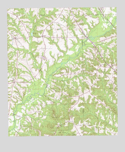
Brundidge SE, AL USGS Topographic Map
Click on map above to begin viewing in our Map Viewer.

This topographic map contains these locations and features:
Feature Name Type Latitude Longitude GNIS ID View Map
Bethel ChurchChurchN31.6124°W85.7963°135304View Map
Blacks Mills (historical)LocaleN31.5871°W85.7894°135298View Map
Bowden Mill CreekStreamN31.6063°W85.7572°151695View Map
Butts BranchStreamN31.5899°W85.8488°135306View Map
Camp BranchStreamN31.5091°W85.8441°135310View Map
Clearwater CreekStreamN31.5554°W85.8291°116242View Map
Coles BridgeBridgeN31.5213°W85.8683°116417View Map
Corinth Primitive Baptist ChurchChurchN31.5963°W85.8655°149946View Map
Crossroad SchoolSchoolN31.5954°W85.8094°116901View Map
Eanon Baptist ChurchChurchN31.5188°W85.8627°149954View Map
Eanon School (historical)SchoolN31.5191°W85.8624°157642View Map
Enon School (historical)SchoolN31.5157°W85.8527°135326View Map
FriscoPopulated PlaceN31.5954°W85.8655°156384View Map
Gin BranchStreamN31.5768°W85.8044°135336View Map
Halls CreekStreamN31.5141°W85.8680°119595View Map
Huckleberry CreekStreamN31.5588°W85.8258°120505View Map
JavaPopulated PlaceN31.5579°W85.8438°156525View Map
Johnson CreekStreamN31.5410°W85.8347°154506View Map
Johnsons BridgeBridgeN31.5507°W85.8297°151903View Map
Kiser Mill CreekStreamN31.5063°W85.8711°121260View Map
Kiser Mill CreekStreamN31.5149°W85.8674°135368View Map
Lawrence (historical)LocaleN31.5485°W85.7527°133499View Map
Lithco CreekStreamN31.5888°W85.7863°152080View Map
Mossy Grove CemeteryCemeteryN31.5313°W85.7644°133517View Map
Mount Olive CemeteryCemeteryN31.5554°W85.7727°123278View Map
Mount Olive ChurchChurchN31.5479°W85.7794°1699908View Map
Mount Olive Church (historical)ChurchN31.5557°W85.7736°133520View Map
Mount Zion Baptist ChurchChurchN31.6082°W85.7933°152523View Map
Mount Zion CemeteryCemeteryN31.6077°W85.7930°137083View Map
New HopePopulated PlaceN31.5529°W85.8677°123780View Map
New Hope Baptist ChurchChurchN31.5541°W85.8680°135390View Map
New Hope CemeteryCemeteryN31.5538°W85.8672°137088View Map
New Hope School (historical)SchoolN31.5532°W85.8677°135391View Map
New Salem ChurchChurchN31.6079°W85.8002°149994View Map
New Tabernacle CemeteryCemeteryN31.5138°W85.8060°157725View Map
New Tabernacle ChurchChurchN31.5138°W85.8063°149996View Map
Pea River BridgeBridgeN31.5952°W85.7830°152860View Map
Pine Union School (historical)SchoolN31.5435°W85.8144°135400View Map
Pitman BranchStreamN31.5796°W85.8472°135402View Map
Pleasant Ridge United Methodist ChurchChurchN31.5460°W85.7538°155905View Map
Prestwood MillpondLakeN31.6001°W85.8466°153063View Map
Rocky HeadPopulated PlaceN31.5682°W85.7686°153202View Map
Rocky Head Baptist ChurchChurchN31.5635°W85.7736°155942View Map
Rocky Head School (historical)SchoolN31.5629°W85.7736°133541View Map
Roe BranchStreamN31.5871°W85.7633°125889View Map
RoetonPopulated PlaceN31.5977°W85.8347°125899View Map
Roeton Baptist ChurchChurchN31.5971°W85.8330°154109View Map
Roeton CemeteryCemeteryN31.5974°W85.8327°137094View Map
Roeton Mill Pond DamDamN31.5985°W85.8466°129897View Map
Saint John Baptist ChurchChurchN31.5529°W85.8561°150014View Map
Saint Johns CemeteryCemeteryN31.5529°W85.8555°157733View Map
Saint Johns School (historical)SchoolN31.5529°W85.8561°157649View Map
Selgar Family CemeteryCemeteryN31.5963°W85.8647°137097View Map
Shellgrove Mill (historical)LocaleN31.5216°W85.8691°135420View Map
Springfield ChurchChurchN31.5438°W85.7811°133556View Map
Springfield School (historical)SchoolN31.5479°W85.7794°157663View Map
Strickland CemeteryCemeteryN31.5968°W85.8655°154110View Map
Tabernacle School (historical)SchoolN31.5088°W85.8194°135431View Map
Tanyard BranchStreamN31.5868°W85.7622°133561View Map
Taynard BranchStreamN31.5907°W85.7874°133562View Map
TennillePopulated PlaceN31.6232°W85.7686°127762View Map
Tennille ChurchChurchN31.6232°W85.7669°139927View Map
West Clearwater CreekStreamN31.6177°W85.8319°153937View Map

Note: Coordinates in the location and feature list above are referenced to NAD83 datum.


Copyright (C) 2008-2025 Ryan Niemi / Sunset Dynamics ... All Rights Reserved