TopoQuest Logo
Do you find TopoQuest useful?
Help keep TopoQuest running and adding new maps/features by donating!
Bitcoin:  19c7KJd3qBynnjoSw5npx9KScwjBe4ifkT
Litecoin:  LXs6TkuXGGXo1vDsWCkWVdjQX94eUKd6ui
Home View Maps Find Maps Find Places Resources & Links


Victoria, Alabama Topographic Map

USGS Map Title: Victoria, AL
USGS Map MRC: 31085E8
DRG (GeoTIFF) Download: o31085e8.tif


Neighboring USGS Topographic Map Quads:


  Goshen, AL  
31086F1
 

  Brundidge NW, AL  
31085F8
 

  Brundidge, AL  
31085F7
 

  Bluff Springs, AL  
31086E1
 

  Victoria, AL  
31085E8
 

  Brundidge SE, AL  
31085E7
 

  Elba, AL  
31086D1
 

  New Brockton, AL  
31085D8
 

  Enterprise NE, AL  
31085D7


Map MRC Location:

N32°
W86°
N32°
W85°
H8 H7 H6 H5 H4 H3 H2 H1
G8 G7 G6 G5 G4 G3 G2 G1
F8 F7 F6 F5 F4 F3 F2 F1
E8 E7 E6 E5 E4 E3 E2 E1
D8 D7 D6 D5 D4 D3 D2 D1
C8 C7 C6 C5 C4 C3 C2 C1
B8 B7 B6 B5 B4 B3 B2 B1
A8 A7 A6 A5 A4 A3 A2 A1
N31°
W86°
N31°
W85°

Victoria, AL USGS 1:24K Topographic Map Preview:
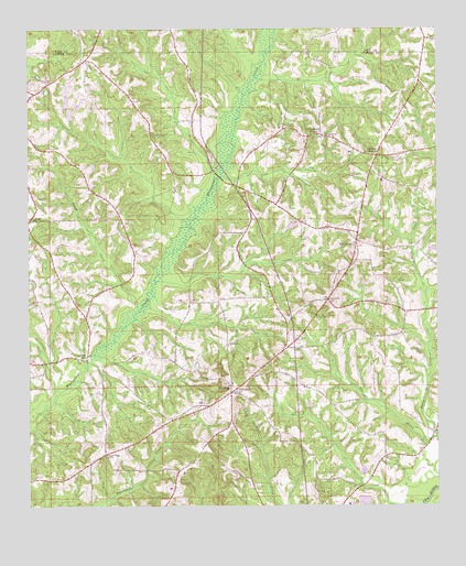
Victoria, AL USGS Topographic Map
Click on map above to begin viewing in our Map Viewer.

This topographic map contains these locations and features:
Feature Name Type Latitude Longitude GNIS ID View Map
Abundant Life Emanuel ChurchChurchN31.5141°W85.8877°135439View Map
ArcusPopulated PlaceN31.5138°W85.9752°135289View Map
Benedick AirportAirportN31.5546°W85.9761°2676343View Map
Busbyville Post Office (historical)Post OfficeN31.5696°W85.9972°166051View Map
Cedar CreekStreamN31.5879°W85.9441°135315View Map
Chapman CreekStreamN31.5741°W85.9505°135316View Map
Chestnut GrovePopulated PlaceN31.5971°W85.9136°116019View Map
Chestnut Grove CemeteryCemeteryN31.5968°W85.9083°137062View Map
Clowers CrossroadsPopulated PlaceN31.5916°W85.8933°156193View Map
Dorcas Baptist ChurchChurchN31.5971°W85.9080°149952View Map
Dry CreekStreamN31.6154°W85.9294°139845View Map
Five Star Volunteer Fire DepartmentBuildingN31.5677°W85.8995°2691316View Map
Gin BranchStreamN31.5866°W85.9405°135337View Map
Haw Hill ChurchChurchN31.5682°W85.8999°119863View Map
Hawhill CemeteryCemeteryN31.5688°W85.8999°137072View Map
Hog CreekStreamN31.6077°W85.9338°135348View Map
Indian Head Post Office (historical)Post OfficeN31.5316°W85.9374°166056View Map
Jack ChurchChurchN31.5682°W85.9947°135356View Map
Jack ChurchChurchN31.5754°W85.9969°135357View Map
Jump CreekStreamN31.5513°W85.9663°121072View Map
Lowry MillPopulated PlaceN31.5388°W85.9822°156633View Map
Perdue Assembly of God ChurchChurchN31.6057°W85.9666°154108View Map
Perdue CemeteryCemeteryN31.6063°W85.9677°137090View Map
Red Oak School (historical)SchoolN31.5510°W85.9836°135406View Map
Rosin Ridge CemeteryCemeteryN31.5135°W85.9761°153219View Map
Shoal CreekStreamN31.5304°W85.9919°126788View Map
Turner BranchStreamN31.5588°W85.9602°135436View Map
Turner CreekStreamN31.5177°W85.8752°128199View Map
VictoriaPopulated PlaceN31.5299°W85.9383°153842View Map
Victoria Ball ParkParkN31.5274°W85.9391°135440View Map
Victoria Baptist ChurchChurchN31.5316°W85.9388°149932View Map
Victoria CemeteryCemeteryN31.5315°W85.9397°137100View Map
Victoria DivisionCivilN31.5448°W85.9006°165712View Map
WilkinstownPopulated PlaceN31.6082°W85.9980°128988View Map
Wolf CreekStreamN31.6124°W85.9299°135445View Map

Note: Coordinates in the location and feature list above are referenced to NAD83 datum.


Copyright (C) 2008-2025 Ryan Niemi / Sunset Dynamics ... All Rights Reserved