TopoQuest Logo
Do you find TopoQuest useful?
Help keep TopoQuest running and adding new maps/features by donating!
Bitcoin:  19c7KJd3qBynnjoSw5npx9KScwjBe4ifkT
Litecoin:  LXs6TkuXGGXo1vDsWCkWVdjQX94eUKd6ui
Home View Maps Find Maps Find Places Resources & Links


Willshire, Ohio Topographic Map

USGS Map Title: Willshire, OH
USGS Map MRC: 40084F7
DRG (GeoTIFF) Download: o40084f7.tif


Neighboring USGS Topographic Map Quads:


  Decatur, IN  
40084G8
 

  Wren, OH  
40084G7
 

  Glenmore, OH  
40084G6
 

  Berne, IN  
40084F8
 

  Willshire, OH  
40084F7
 

  Rockford, OH  
40084F6
 

  Geneva, IN  
40084E8
 

  New Corydon, IN  
40084E7
 

  Erastus, OH  
40084E6


Map MRC Location:

N41°
W85°
N41°
W84°
H8 H7 H6 H5 H4 H3 H2 H1
G8 G7 G6 G5 G4 G3 G2 G1
F8 F7 F6 F5 F4 F3 F2 F1
E8 E7 E6 E5 E4 E3 E2 E1
D8 D7 D6 D5 D4 D3 D2 D1
C8 C7 C6 C5 C4 C3 C2 C1
B8 B7 B6 B5 B4 B3 B2 B1
A8 A7 A6 A5 A4 A3 A2 A1
N40°
W85°
N40°
W84°

Willshire, OH USGS 1:24K Topographic Map Preview:
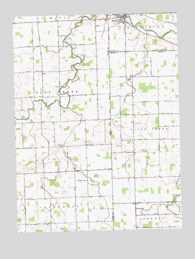
Willshire, OH USGS Topographic Map
Click on map above to begin viewing in our Map Viewer.

This topographic map contains these locations and features:
Feature Name Type Latitude Longitude GNIS ID View Map
Adam's FarmsLocaleN40.6581°W84.8628°2628487View Map
Adams Swine FarmsLocaleN40.6736°W84.8303°2628488View Map
Bethel ChurchChurchN40.6542°W84.8214°430942View Map
Blue Creek Amish SchoolSchoolN40.6748°W84.8208°431221View Map
Brumback Library Willshire BranchBuildingN40.7475°W84.7906°2707382View Map
Calvary ChurchChurchN40.6512°W84.8686°431985View Map
ChattanoogaPopulated PlaceN40.6370°W84.7850°1039008View Map
Chattanooga Fire DepartmentBuildingN40.6382°W84.7847°2549619View Map
Chattanooga Post Office (historical)Post OfficeN40.6375°W84.7847°2036718View Map
Duck CreekStreamN40.7398°W84.7730°1039846View Map
Duck Creek CemeteryCemeteryN40.6864°W84.7850°1039848View Map
Duck Creek School (historical)SchoolN40.6812°W84.7855°1053567View Map
Hamrick AirportAirportN40.6936°W84.7847°1083121View Map
Little Blue CreekStreamN40.6964°W84.8347°437992View Map
Mount Hope ChurchChurchN40.6742°W84.8397°439584View Map
Number 3 School (historical)SchoolN40.7128°W84.7852°1053568View Map
Parkway Middle SchoolSchoolN40.7445°W84.7908°1067087View Map
Pleasant Mills QuarryMineN40.7383°W84.8292°2649679View Map
Saint Paul ChurchChurchN40.6337°W84.7714°1045746View Map
SalemPopulated PlaceN40.7170°W84.8533°442875View Map
School Number 3 (historical)SchoolN40.6259°W84.7844°1053565View Map
Township of Blue CreekCivilN40.7032°W84.8408°453116View Map
Tricker CemeteryCemeteryN40.7087°W84.8394°444883View Map
Union ChurchChurchN40.7437°W84.8114°445116View Map
Village of WillshireCivilN40.7466°W84.7925°2399703View Map
Wildcat School (historical)SchoolN40.6548°W84.7847°1053566View Map
WillshirePopulated PlaceN40.7487°W84.7911°1061791View Map
Willshire CemeteryCemeteryN40.7439°W84.7855°1807440View Map
Willshire Fire DepartmentBuildingN40.7481°W84.7906°2549813View Map
Willshire Post OfficePost OfficeN40.7486°W84.7917°2081249View Map
Willshire United Methodist ChurchChurchN40.7467°W84.7930°1961450View Map
Winkler Airport (historical)AirportN40.7023°W84.7644°1083122View Map
Zion CemeteryCemeteryN40.6337°W84.7814°1048257View Map

Note: Coordinates in the location and feature list above are referenced to NAD83 datum.


Copyright (C) 2008-2024 Ryan Niemi / Sunset Dynamics ... All Rights Reserved