TopoQuest Logo
Do you find TopoQuest useful?
Help keep TopoQuest running and adding new maps/features by donating!
Bitcoin:  19c7KJd3qBynnjoSw5npx9KScwjBe4ifkT
Litecoin:  LXs6TkuXGGXo1vDsWCkWVdjQX94eUKd6ui
Home View Maps Find Maps Find Places Resources & Links


New Florence, Pennsylvania Topographic Map

USGS Map Title: New Florence, PA
USGS Map MRC: 40079D1
DRG (GeoTIFF) Download: o40079d1.tif


Neighboring USGS Topographic Map Quads:


  Indiana, PA  
40079E2
 

  Brush Valley, PA  
40079E1
 

  Strongstown, PA  
40078E8
 

  Bolivar, PA  
40079D2
 

  New Florence, PA  
40079D1
 

  Vintondale, PA  
40078D8
 

  Wilpen, PA  
40079C2
 

  Rachelwood, PA  
40079C1
 

  Johnstown, PA  
40078C8


Map MRC Location:

N41°
W80°
N41°
W79°
H8 H7 H6 H5 H4 H3 H2 H1
G8 G7 G6 G5 G4 G3 G2 G1
F8 F7 F6 F5 F4 F3 F2 F1
E8 E7 E6 E5 E4 E3 E2 E1
D8 D7 D6 D5 D4 D3 D2 D1
C8 C7 C6 C5 C4 C3 C2 C1
B8 B7 B6 B5 B4 B3 B2 B1
A8 A7 A6 A5 A4 A3 A2 A1
N40°
W80°
N40°
W79°

New Florence, PA USGS 1:24K Topographic Map Preview:
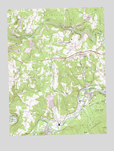
New Florence, PA USGS Topographic Map
Click on map above to begin viewing in our Map Viewer.

This topographic map contains these locations and features:
Feature Name Type Latitude Longitude GNIS ID View Map
ArmaghPopulated PlaceN40.4537°W79.0320°1168395View Map
Armagh CemeteryCemeteryN40.4520°W79.0208°1168396View Map
Armagh East Wheatfield Volunteer Fire Department Station 210BuildingN40.4530°W79.0314°2644736View Map
Armagh Post OfficePost OfficeN40.4540°W79.0309°2772575View Map
Aulds RunStreamN40.4726°W79.1067°1168512View Map
Baldwin CreekStreamN40.3784°W79.0648°1168655View Map
Bethel CemeteryCemeteryN40.4337°W79.0683°1169361View Map
Beuna Vista Iron FurnaceLocaleN40.4806°W79.0470°1209257View Map
Big Spring DamDamN40.4067°W79.0013°1194789View Map
Big Spring ReservoirReservoirN40.4068°W79.0004°1169597View Map
Big Spring RunStreamN40.4028°W79.0309°1192142View Map
BoltzPopulated PlaceN40.4209°W79.0028°1169967View Map
Borough of ArmaghCivilN40.4536°W79.0325°1215282View Map
Borough of New FlorenceCivilN40.3791°W79.0751°1215713View Map
Borough of SewardCivilN40.4131°W79.0219°1215721View Map
Brush CreekStreamN40.4876°W79.0756°1170438View Map
Centerville (historical)Populated PlaceN40.3895°W79.0734°1209293View Map
Citizens Ambulance Service Wheatfield StationBuildingN40.4495°W79.0705°2719612View Map
ClaghornPopulated PlaceN40.4878°W79.0750°1203279View Map
ClimaxPopulated PlaceN40.3853°W79.1242°1172007View Map
ClydePopulated PlaceN40.4498°W79.0700°1217345View Map
Clyde Volunteer Fire Department Station 250BuildingN40.4493°W79.0711°2645474View Map
Conpitt JunctionPopulated PlaceN40.3759°W79.1025°1203327View Map
Conrad CemeteryCemeteryN40.4812°W79.0128°1172363View Map
Culbert SchoolSchoolN40.4103°W79.0520°1200880View Map
DiasPopulated PlaceN40.4812°W79.0445°1203413View Map
DilltownPopulated PlaceN40.4665°W79.0025°1173275View Map
Dilltown Post OfficePost OfficeN40.4684°W79.0003°2773118View Map
District DamDamN40.3867°W79.0231°1194777View Map
East Branch Richards RunStreamN40.4162°W79.1148°1173766View Map
GermanyPopulated PlaceN40.4203°W79.1167°1175567View Map
Hedges LakesReservoirN40.4145°W79.0509°1176762View Map
HeshbonPopulated PlaceN40.4720°W79.0945°1176907View Map
Heshbon SchoolSchoolN40.4828°W79.1092°1200883View Map
High Ridge ReservoirReservoirN40.3867°W79.0231°1194776View Map
Holiday LakeReservoirN40.4420°W79.0676°1177199View Map
HoovervillePopulated PlaceN40.4128°W79.0270°1177375View Map
IndiaPopulated PlaceN40.3765°W79.1195°1177731View Map
Laurel Valley Ambulance ServiceBuildingN40.3790°W79.0767°2719510View Map
LockportPopulated PlaceN40.3917°W79.1220°1179761View Map
Lockport StationBuildingN40.3917°W79.1231°1200882View Map
Mardis RunStreamN40.4665°W79.0006°1180396View Map
Mardis RunStreamN40.4756°W79.0295°1198091View Map
New FlorencePopulated PlaceN40.3803°W79.0753°1182316View Map
New Florence Post OfficePost OfficeN40.3783°W79.0756°2772871View Map
New Florence Volunteer Fire DepartmentBuildingN40.3794°W79.0761°2645517View Map
Oakgrove School (historical)SchoolN40.4995°W79.0359°1200875View Map
Oneida Mine StationLocaleN40.4767°W79.0373°1212071View Map
Ramsey RunStreamN40.4720°W79.0945°1184635View Map
RobbPopulated PlaceN40.3923°W79.0378°1185192View Map
Robbs SchoolSchoolN40.3959°W79.0331°1200881View Map
Robindale (historical)Populated PlaceN40.4009°W79.0367°1209329View Map
Robindale HeightsPopulated PlaceN40.4265°W79.0248°1209258View Map
Saint Marys CemeteryCemeteryN40.4345°W79.1075°1186378View Map
ScottglenLocaleN40.4684°W79.0131°1200877View Map
Scottglen StationLocaleN40.4737°W79.0048°1200876View Map
SewardPopulated PlaceN40.4142°W79.0200°1187276View Map
Seward Post OfficePost OfficeN40.4154°W79.0242°2772972View Map
Seward Volunteer Fire DepartmentBuildingN40.4132°W79.0235°2645081View Map
Shellbark School (historical)SchoolN40.4656°W79.0486°1200878View Map
Smokeless Post Office (historical)Post OfficeN40.4012°W79.0348°1214200View Map
Squirrel HillSummitN40.3765°W79.0820°1188372View Map
Sugar RunStreamN40.4028°W79.0278°1188969View Map
Sugar Run DamDamN40.3763°W79.0227°1194766View Map
Sugar Run ReservoirReservoirN40.3752°W79.0245°1188976View Map
Township of East WheatfieldCivilN40.4438°W79.0085°1216542View Map
Township of West WheatfieldCivilN40.4273°W79.1058°1216552View Map
Trindle SchoolSchoolN40.4306°W79.0264°1200879View Map
United Elementary SchoolSchoolN40.4692°W79.0423°1207204View Map
United Joint High SchoolSchoolN40.4656°W79.0453°1190202View Map
VeronaLocaleN40.4217°W79.0264°1207097View Map
Wallace SchoolSchoolN40.3981°W79.1011°1201104View Map
West Branch Richards RunStreamN40.4159°W79.1148°1190929View Map

Note: Coordinates in the location and feature list above are referenced to NAD83 datum.


Copyright (C) 2008-2024 Ryan Niemi / Sunset Dynamics ... All Rights Reserved