TopoQuest Logo
Do you find TopoQuest useful?
Help keep TopoQuest running and adding new maps/features by donating!
Bitcoin:  19c7KJd3qBynnjoSw5npx9KScwjBe4ifkT
Litecoin:  LXs6TkuXGGXo1vDsWCkWVdjQX94eUKd6ui
Home View Maps Find Maps Find Places Resources & Links


Brush Valley, Pennsylvania Topographic Map

USGS Map Title: Brush Valley, PA
USGS Map MRC: 40079E1
DRG (GeoTIFF) Download: o40079e1.tif


Neighboring USGS Topographic Map Quads:


  Ernest, PA  
40079F2
 

  Clymer, PA  
40079F1
 

  Commodore, PA  
40078F8
 

  Indiana, PA  
40079E2
 

  Brush Valley, PA  
40079E1
 

  Strongstown, PA  
40078E8
 

  Bolivar, PA  
40079D2
 

  New Florence, PA  
40079D1
 

  Vintondale, PA  
40078D8


Map MRC Location:

N41°
W80°
N41°
W79°
H8 H7 H6 H5 H4 H3 H2 H1
G8 G7 G6 G5 G4 G3 G2 G1
F8 F7 F6 F5 F4 F3 F2 F1
E8 E7 E6 E5 E4 E3 E2 E1
D8 D7 D6 D5 D4 D3 D2 D1
C8 C7 C6 C5 C4 C3 C2 C1
B8 B7 B6 B5 B4 B3 B2 B1
A8 A7 A6 A5 A4 A3 A2 A1
N40°
W80°
N40°
W79°

Brush Valley, PA USGS 1:24K Topographic Map Preview:
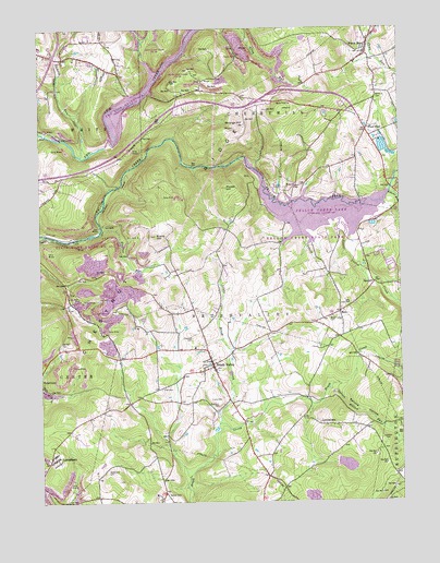
Brush Valley, PA USGS Topographic Map
Click on map above to begin viewing in our Map Viewer.

This topographic map contains these locations and features:
Feature Name Type Latitude Longitude GNIS ID View Map
Bennett Airport (historical)AirportN40.6209°W79.1123°1194047View Map
Brush ValleyPopulated PlaceN40.5362°W79.0664°1170464View Map
Brush Valley CemeteryCemeteryN40.5490°W79.0233°1170468View Map
Brush Valley Post OfficePost OfficeN40.5368°W79.0651°2773087View Map
Brush Valley Volunteer Fire Department Station 230BuildingN40.5357°W79.0662°2645700View Map
Cherryhill Township Volunteer Fire Department Station 240BuildingN40.6180°W79.0103°2645635View Map
Dutch Bethel Evangelical CemeteryCemeteryN40.5020°W79.0812°1169362View Map
Elroy Face DamDamN40.5917°W79.0048°1194928View Map
Evans CemeteryCemeteryN40.5273°W79.0614°1174343View Map
Evans Field (historical)AirportN40.5820°W79.0623°1194030View Map
Evans HillSummitN40.5706°W79.0839°1174346View Map
Ferrier RunStreamN40.5726°W79.1031°1174710View Map
Frye CemeteryCemeteryN40.5300°W79.0828°1175314View Map
Gillhouser RunStreamN40.5526°W79.0000°1192511View Map
GreenvilleLocaleN40.6190°W79.0114°1201000View Map
Lake MargusReservoirN40.5937°W79.0055°1194927View Map
Laurel RunStreamN40.5815°W79.0028°1179010View Map
Little Brush CreekStreamN40.5206°W79.0631°1179485View Map
Little Yellow CreekStreamN40.5687°W79.0178°1179717View Map
LittletownPopulated PlaceN40.5203°W79.0259°1179724View Map
Lucerne DamDamN40.5684°W79.1198°1194905View Map
LuciusboroPopulated PlaceN40.5106°W79.1223°1180061View Map
MechanicsburgLocaleN40.5351°W79.0628°1201001View Map
MentchLocaleN40.6040°W79.0389°1214207View Map
Moose HillSummitN40.5828°W79.0592°1181524View Map
Penn RunPopulated PlaceN40.6187°W79.0111°1183485View Map
Penn Run Post OfficePost OfficeN40.6174°W79.0103°2772903View Map
Pikes PeakPopulated PlaceN40.5984°W79.0109°1183733View Map
Pond Number FourReservoirN40.5484°W79.0814°1194899View Map
Pond Number Four DamDamN40.5484°W79.0814°1194898View Map
Ramsey RunStreamN40.5917°W79.1100°1184637View Map
RicoPopulated PlaceN40.5501°W79.0200°1185026View Map
Robinson CemeteryCemeteryN40.5253°W79.0628°1185223View Map
South Branch Brush CreekStreamN40.5259°W79.0306°1202630View Map
Spruce HollowValleyN40.5288°W79.0217°1188332View Map
Spruce Hollow RunStreamN40.5298°W79.0250°1188333View Map
Stake ChurchChurchN40.5837°W79.0353°1188385View Map
State Game Lands Number 248ParkN40.6167°W79.0831°1208590View Map
State Game Lands Number 273ParkN40.5584°W79.1164°1208407View Map
Strongs HillSummitN40.6001°W79.0528°1188889View Map
SuncliffPopulated PlaceN40.5578°W79.0084°1189065View Map
SuncliffCliffN40.5528°W79.0048°1201470View Map
Township of Brush ValleyCivilN40.5308°W79.0613°1216534View Map
Two Lick Creek DamDamN40.5917°W79.0998°1194930View Map
Two Lick Creek ReservoirReservoirN40.5917°W79.0998°1194931View Map
Yellow Creek State ParkParkN40.5684°W79.0264°1196518View Map
Yellow Creek State Park DamDamN40.5917°W79.0564°1194929View Map

Note: Coordinates in the location and feature list above are referenced to NAD83 datum.


Copyright (C) 2008-2025 Ryan Niemi / Sunset Dynamics ... All Rights Reserved