TopoQuest Logo
Do you find TopoQuest useful?
Help keep TopoQuest running and adding new maps/features by donating!
Bitcoin:  19c7KJd3qBynnjoSw5npx9KScwjBe4ifkT
Litecoin:  LXs6TkuXGGXo1vDsWCkWVdjQX94eUKd6ui
Home View Maps Find Maps Find Places Resources & Links


New Hebron, Mississippi Topographic Map

USGS Map Title: New Hebron, MS
USGS Map MRC: 31089F8
DRG (GeoTIFF) Download: o31089f8.tif


Neighboring USGS Topographic Map Quads:


  Schley, MS  
31090G1
 

  Shivers, MS  
31089G8
 

  Mendenhall SE, MS  
31089G7
 

  Monticello NE, MS  
31090F1
 

  New Hebron, MS  
31089F8
 

  Mount Carmel, MS  
31089F7
 

  Monticello, MS  
31090E1
 

  Prentiss West, MS  
31089E8
 

  Prentiss East, MS  
31089E7


Map MRC Location:

N32°
W90°
N32°
W89°
H8 H7 H6 H5 H4 H3 H2 H1
G8 G7 G6 G5 G4 G3 G2 G1
F8 F7 F6 F5 F4 F3 F2 F1
E8 E7 E6 E5 E4 E3 E2 E1
D8 D7 D6 D5 D4 D3 D2 D1
C8 C7 C6 C5 C4 C3 C2 C1
B8 B7 B6 B5 B4 B3 B2 B1
A8 A7 A6 A5 A4 A3 A2 A1
N31°
W90°
N31°
W89°

New Hebron, MS USGS 1:24K Topographic Map Preview:
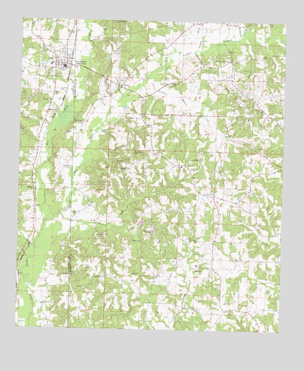
New Hebron, MS USGS Topographic Map
Click on map above to begin viewing in our Map Viewer.

This topographic map contains these locations and features:
Feature Name Type Latitude Longitude GNIS ID View Map
Armstrong CemeteryCemeteryN31.7049°W89.9040°691290View Map
Benson CemeteryCemeteryN31.6938°W89.9926°666831View Map
Bethel ChurchChurchN31.6902°W89.9779°666910View Map
Cole ChurchChurchN31.6549°W89.9976°668672View Map
Dampeer CemeteryCemeteryN31.7177°W89.9854°669089View Map
Droummonds CemeteryCemeteryN31.7138°W89.9837°669387View Map
Dry Hollow School (historical)SchoolN31.7010°W89.9129°689729View Map
East Prong Silver CreekStreamN31.6682°W89.9867°669603View Map
Fiddlers CreekStreamN31.6713°W89.9809°669954View Map
Galilee CemeteryCemeteryN31.6902°W89.9487°691294View Map
Galilee ChurchChurchN31.6899°W89.9492°670290View Map
Galilee School (historical)SchoolN31.6896°W89.9495°689732View Map
Gholar CemeteryCemeteryN31.6610°W89.9456°670366View Map
GrangeLocaleN31.6810°W89.9929°670585View Map
Gwinville BranchStreamN31.7385°W89.9165°670812View Map
Hartzog CemeteryCemeteryN31.6438°W89.8826°691291View Map
HebronPopulated PlaceN31.7235°W89.9523°691928View Map
Hebron CemeteryCemeteryN31.7204°W89.9570°671061View Map
Hebron ChurchChurchN31.7221°W89.9498°689740View Map
Hookers Store (historical)LocaleN31.6493°W89.9359°689743View Map
Hutchens BranchStreamN31.7268°W89.9398°671643View Map
Hutchens CemeteryCemeteryN31.7252°W89.9284°691568View Map
Lee CemeteryCemeteryN31.6996°W89.8842°672370View Map
Magee CemeteryCemeteryN31.6507°W89.9326°691295View Map
Mobley CemeteryCemeteryN31.6715°W89.9729°673719View Map
Myers CemeteryCemeteryN31.7368°W89.9340°674493View Map
New HebronPopulated PlaceN31.7310°W89.9787°674644View Map
New Hebron Police DepartmentBuildingN31.7308°W89.9784°2754184View Map
New Hebron Post OfficePost OfficeN31.7309°W89.9798°2768848View Map
New Hebron SchoolSchoolN31.7318°W89.9856°709271View Map
New Hebron Volunteer Fire DepartmentBuildingN31.7307°W89.9784°2668039View Map
North Silver Creek CemeteryCemeteryN31.7349°W89.9020°691289View Map
North Silver Creek ChurchChurchN31.7346°W89.9020°674961View Map
Oakley Junior High SchoolSchoolN31.6913°W89.9229°675129View Map
Old Mobley CemeteryCemeteryN31.7127°W89.9179°691292View Map
Paine CemeteryCemeteryN31.6940°W89.9137°675385View Map
Partman BranchStreamN31.7446°W89.8959°675479View Map
Partman CemeteryCemeteryN31.6893°W89.9037°691594View Map
R G Bilbo Lake DamDamN31.7202°W89.9617°680849View Map
Ross CemeteryCemeteryN31.6696°W89.9634°691298View Map
Ross CemeteryCemeteryN31.6682°W89.9742°691299View Map
Saint Marys ChurchChurchN31.7496°W89.9545°677151View Map
Sills CemeteryCemeteryN31.6813°W89.9773°691321View Map
Silver Creek School (historical)SchoolN31.6746°W89.9642°689774View Map
Smith CemeteryCemeteryN31.6382°W89.9362°691296View Map
Smith CemeteryCemeteryN31.6493°W89.9159°677904View Map
Smith CemeteryCemeteryN31.7221°W89.9817°677906View Map
Sophia Sutton MissionChurchN31.6652°W89.9359°677979View Map
Spring Hill CemeteryCemeteryN31.6471°W89.9590°691300View Map
Spring Hill ChurchChurchN31.6463°W89.9590°678110View Map
Stater CemeteryCemeteryN31.7360°W89.8856°678249View Map
Supervisor District 5CivilN31.6776°W89.9149°711918View Map
Sutton CemeteryCemeteryN31.6610°W89.9192°678445View Map
Town of New HebronCivilN31.7332°W89.9833°2406975View Map
Walder Spring School (historical)SchoolN31.6343°W89.8773°689777View Map
Weathersby CemeteryCemeteryN31.6963°W89.9459°679407View Map
West Prong Silver CreekStreamN31.6679°W89.9867°679524View Map
Whiting School (historical)SchoolN31.6391°W89.9123°689780View Map
Wolfe CemeteryCemeteryN31.7079°W89.9390°691293View Map
Yellowleaf School (historical)SchoolN31.6891°W89.9467°689781View Map
Zion Hill CemeteryCemeteryN31.6482°W89.9456°691297View Map
Zion Hill ChurchChurchN31.6477°W89.9456°680018View Map

Note: Coordinates in the location and feature list above are referenced to NAD83 datum.


Copyright (C) 2008-2025 Ryan Niemi / Sunset Dynamics ... All Rights Reserved