TopoQuest Logo
Do you find TopoQuest useful?
Help keep TopoQuest running and adding new maps/features by donating!
Bitcoin:  19c7KJd3qBynnjoSw5npx9KScwjBe4ifkT
Litecoin:  LXs6TkuXGGXo1vDsWCkWVdjQX94eUKd6ui
Home View Maps Find Maps Find Places Resources & Links


New Richland, Minnesota Topographic Map

USGS Map Title: New Richland, MN
USGS Map MRC: 43093H4
DRG (GeoTIFF) Download: o43093h4.tif


Neighboring USGS Topographic Map Quads:


  Waseca, MN  
44093A5
 

  Meriden, MN  
44093A4
 

  Saco, MN  
44093A3
 

  Otisco, MN  
43093H5
 

  New Richland, MN  
43093H4
 

  Hope, MN  
43093H3
 

  Freeborn, MN  
43093G5
 

  Hartland, MN  
43093G4
 

  Ellendale, MN  
43093G3


Map MRC Location:

N44°
W94°
N44°
W93°
H8 H7 H6 H5 H4 H3 H2 H1
G8 G7 G6 G5 G4 G3 G2 G1
F8 F7 F6 F5 F4 F3 F2 F1
E8 E7 E6 E5 E4 E3 E2 E1
D8 D7 D6 D5 D4 D3 D2 D1
C8 C7 C6 C5 C4 C3 C2 C1
B8 B7 B6 B5 B4 B3 B2 B1
A8 A7 A6 A5 A4 A3 A2 A1
N43°
W94°
N43°
W93°

New Richland, MN USGS 1:24K Topographic Map Preview:
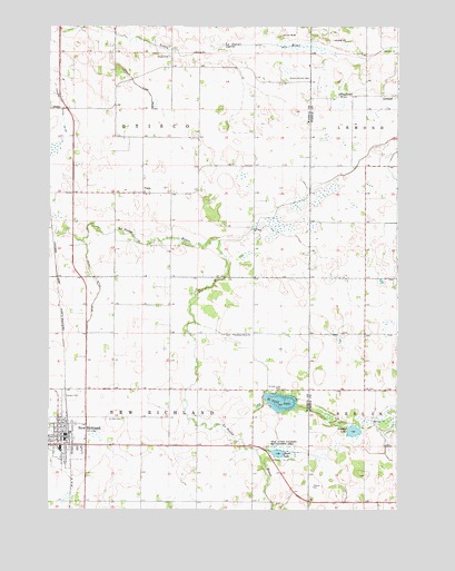
New Richland, MN USGS Topographic Map
Click on map above to begin viewing in our Map Viewer.

This topographic map contains these locations and features:
Feature Name Type Latitude Longitude GNIS ID View Map
Calvary CemeteryCemeteryN43.9038°W93.4949°640745View Map
Church of All SaintsChurchN43.8930°W93.4966°2051200View Map
City of New RichlandCivilN43.8939°W93.4939°2395213View Map
County Ditch Number ThirtythreeCanalN43.9844°W93.4683°641969View Map
County Ditch Number TwentysevenCanalN43.9341°W93.4830°641883View Map
First Congregational ChurchChurchN43.8938°W93.4955°2051198View Map
Fosilen LakeLakeN43.8955°W93.3906°643829View Map
Johnson Oakside OrchardLocaleN43.9842°W93.3989°2651178View Map
Judicial Ditch Number FiveCanalN43.9955°W93.4202°645934View Map
Le Sueur River American Lutheran Church CemeteryCemeteryN43.9202°W93.4338°2051225View Map
Le Sueur River ChurchChurchN43.9202°W93.4341°646551View Map
LemondPopulated PlaceN43.9825°W93.3802°654791View Map
Lemond Post Office (historical)Post OfficeN43.9825°W93.3802°2051255View Map
New RichlandLocaleN43.8944°W93.4919°2051202View Map
New RichlandPopulated PlaceN43.8938°W93.4938°648518View Map
New Richland AmbulanceBuildingN43.8953°W93.4935°2721319View Map
New Richland Care CenterHospitalN43.8952°W93.4891°2051195View Map
New Richland City HallBuildingN43.8952°W93.4936°2051194View Map
New Richland ClinicHospitalN43.8925°W93.4977°2051196View Map
New Richland Fire DepartmentBuildingN43.8952°W93.4934°2051193View Map
New Richland Police DepartmentBuildingN43.8952°W93.4934°2051192View Map
New Richland Post OfficePost OfficeN43.8947°W93.4936°2051190View Map
New Richland Public LibraryBuildingN43.8947°W93.4936°2051191View Map
New Richland Public SchoolSchoolN43.8908°W93.4955°2051201View Map
Otisco - Lemond CemeteryCemeteryN43.9866°W93.4069°649036View Map
Otisco CemeteryCemeteryN43.9925°W93.4566°2051224View Map
Pontoppidan Lutheran CemeteryCemeteryN43.9819°W93.3955°2051372View Map
Pontoppidan Lutheran ChurchChurchN43.9819°W93.3955°2051373View Map
Reese LakeLakeN43.8897°W93.4178°649913View Map
Saint Olaf CemeteryCemeteryN43.8983°W93.4791°650925View Map
Saint Olaf LakeReservoirN43.9000°W93.4202°1776080View Map
Saint Olaf LakeLakeN43.9030°W93.4168°650932View Map
Saint Olaf Lake DamDamN43.9000°W93.4202°1776079View Map
Saint Olaf Lake ParkParkN43.9058°W93.4166°650933View Map
Saint Peter's Lutheran ChurchChurchN43.8963°W93.4955°2051197View Map
School Number 2137SchoolN43.9825°W93.3963°651528View Map
Teal State Wildlife Management AreaParkN43.8902°W93.4160°653060View Map
Township of New RichlandCivilN43.8915°W93.4664°665110View Map
Township of OtiscoCivilN43.9788°W93.4666°665235View Map
Trinity Lutheran ChurchChurchN43.8944°W93.4955°2051199View Map
VistaPopulated PlaceN43.9572°W93.4666°654988View Map
Vista Covenant Church CemeteryCemeteryN43.9566°W93.4697°2051223View Map
Vista Evangelical Covenant ChurchChurchN43.9572°W93.4658°2051204View Map
Vista Lutheran ChurchChurchN43.9575°W93.4727°2051205View Map
Vista Post Office (historical)Post OfficeN43.9572°W93.4666°2051118View Map
Vista Swedish Lutheran Church CemeteryCemeteryN43.9572°W93.4697°2051222View Map

Note: Coordinates in the location and feature list above are referenced to NAD83 datum.


Copyright (C) 2008-2025 Ryan Niemi / Sunset Dynamics ... All Rights Reserved