TopoQuest Logo
Do you find TopoQuest useful?
Help keep TopoQuest running and adding new maps/features by donating!
Bitcoin:  19c7KJd3qBynnjoSw5npx9KScwjBe4ifkT
Litecoin:  LXs6TkuXGGXo1vDsWCkWVdjQX94eUKd6ui
Home View Maps Find Maps Find Places Resources & Links


New Salem, Kansas Topographic Map

USGS Map Title: New Salem, KS
USGS Map MRC: 37096C8
DRG (GeoTIFF) Download: o37096c8.tif


Neighboring USGS Topographic Map Quads:


  Udall, KS  
37097D1
 

  Wilmot, KS  
37096D8
 

  Atlanta, KS  
37096D7
 

  Akron, KS  
37097C1
 

  New Salem, KS  
37096C8
 

  Burden, KS  
37096C7
 

  Hackney, KS  
37097B1
 

  Winfield, KS  
37096B8
 

  Eaton, KS  
37096B7


Map MRC Location:

N38°
W97°
N38°
W96°
H8 H7 H6 H5 H4 H3 H2 H1
G8 G7 G6 G5 G4 G3 G2 G1
F8 F7 F6 F5 F4 F3 F2 F1
E8 E7 E6 E5 E4 E3 E2 E1
D8 D7 D6 D5 D4 D3 D2 D1
C8 C7 C6 C5 C4 C3 C2 C1
B8 B7 B6 B5 B4 B3 B2 B1
A8 A7 A6 A5 A4 A3 A2 A1
N37°
W97°
N37°
W96°

New Salem, KS USGS 1:24K Topographic Map Preview:
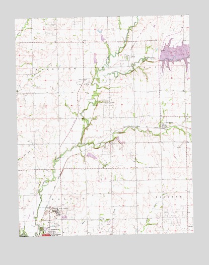
New Salem, KS USGS Topographic Map
Click on map above to begin viewing in our Map Viewer.

This topographic map contains these locations and features:
Feature Name Type Latitude Longitude GNIS ID View Map
Abel Ranch Airport (historical)AirportN37.3667°W96.8792°2651081View Map
Biddle Oil FieldOilfieldN37.2953°W96.9317°469919View Map
Cedar CreekStreamN37.3017°W96.9573°469928View Map
Cedarview SchoolSchoolN37.2639°W96.9725°481179View Map
Country View Elementary SchoolSchoolN37.2538°W96.8786°2497448View Map
Country View Elementary SchoolSchoolN37.2538°W96.8786°469920View Map
Davis FieldAirportN37.2576°W96.9610°2770407View Map
Deichman Oil FieldOilfieldN37.3378°W96.9525°469915View Map
Dutch CreekStreamN37.3411°W96.9417°469925View Map
FloralPopulated PlaceN37.3528°W96.9209°484491View Map
Grand View Church (historical)ChurchN37.3603°W96.9514°483424View Map
Grand View School (historical)SchoolN37.3464°W96.9609°483425View Map
Grandview United Methodist ChurchChurchN37.3602°W96.9514°2691045View Map
Harmony School (historical)SchoolN37.2806°W96.8923°483430View Map
Hittle Oil FieldOilfieldN37.3311°W96.9950°469916View Map
Kansas Veteran's Home Bleckley HallBuildingN37.2608°W96.9688°2624868View Map
Kansas Veteran's Home Donlon HallBuildingN37.2607°W96.9668°2624869View Map
Kansas Veterans' Cemetery at WinfieldCemeteryN37.2608°W96.9768°2770057View Map
KYQQ - FM (Winfield)BuildingN37.3565°W96.9654°2625323View Map
Maple Grove School (historical)SchoolN37.2878°W96.9475°483437View Map
New SalemPopulated PlaceN37.3106°W96.8953°469917View Map
Olive School (historical)SchoolN37.2686°W96.9964°483452View Map
Science Valley School (historical)SchoolN37.2520°W96.9628°483472View Map
Sunnyside SchoolSchoolN37.3614°W96.9517°469914View Map
Township of FairviewCivilN37.3463°W96.9882°469927View Map
Township of SalemCivilN37.3363°W96.8804°469924View Map
Township of WalnutCivilN37.2558°W96.9628°469557View Map
Union CemeteryCemeteryN37.2544°W96.9839°469921View Map
Wilmot Floral Oil FieldOilfieldN37.3247°W96.9342°469918View Map
Winfield Correctional FacilityBuildingN37.2647°W96.9756°2504379View Map
Winfield State HospitalHospitalN37.2639°W96.9725°469922View Map
Winfield Water Treatment PlantLocaleN37.2693°W96.9693°2693255View Map

Note: Coordinates in the location and feature list above are referenced to NAD83 datum.


Copyright (C) 2008-2025 Ryan Niemi / Sunset Dynamics ... All Rights Reserved