TopoQuest Logo
Do you find TopoQuest useful?
Help keep TopoQuest running and adding new maps/features by donating!
Bitcoin:  19c7KJd3qBynnjoSw5npx9KScwjBe4ifkT
Litecoin:  LXs6TkuXGGXo1vDsWCkWVdjQX94eUKd6ui
Home View Maps Find Maps Find Places Resources & Links


Akron, Kansas Topographic Map

USGS Map Title: Akron, KS
USGS Map MRC: 37097C1
DRG (GeoTIFF) Download: o37097c1.tif


Neighboring USGS Topographic Map Quads:


  Mulvane, KS  
37097D2
 

  Udall, KS  
37097D1
 

  Wilmot, KS  
37096D8
 

  Oxford, KS  
37097C2
 

  Akron, KS  
37097C1
 

  New Salem, KS  
37096C8
 

  Adamsville, KS  
37097B2
 

  Hackney, KS  
37097B1
 

  Winfield, KS  
37096B8


Map MRC Location:

N38°
W98°
N38°
W97°
H8 H7 H6 H5 H4 H3 H2 H1
G8 G7 G6 G5 G4 G3 G2 G1
F8 F7 F6 F5 F4 F3 F2 F1
E8 E7 E6 E5 E4 E3 E2 E1
D8 D7 D6 D5 D4 D3 D2 D1
C8 C7 C6 C5 C4 C3 C2 C1
B8 B7 B6 B5 B4 B3 B2 B1
A8 A7 A6 A5 A4 A3 A2 A1
N37°
W98°
N37°
W97°

Akron, KS USGS 1:24K Topographic Map Preview:
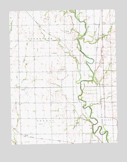
Akron, KS USGS Topographic Map
Click on map above to begin viewing in our Map Viewer.

This topographic map contains these locations and features:
Feature Name Type Latitude Longitude GNIS ID View Map
AkronPopulated PlaceN37.3517°W97.0150°484500View Map
Akron CemeteryCemeteryN37.3607°W97.0246°470126View Map
Bethel School (historical)SchoolN37.2886°W97.0156°483402View Map
Blue School (historical)SchoolN37.3325°W97.0987°483404View Map
Cherokee StripAirportN37.3711°W97.1082°2651033View Map
Crooked CreekStreamN37.3067°W97.0430°470571View Map
DalePopulated PlaceN37.3375°W97.0539°484529View Map
Elsberry School (historical)SchoolN37.2742°W97.0786°483412View Map
Foos CreekStreamN37.3120°W97.0275°470124View Map
KelloggPopulated PlaceN37.2592°W97.1095°484528View Map
Little Dutch CreekStreamN37.3459°W97.0425°470125View Map
Lone Elm CreekStreamN37.2842°W97.0328°470123View Map
Mount Carmel School (historical)SchoolN37.3139°W97.0067°483441View Map
Mount Vernon CemeteryCemeteryN37.2810°W97.0775°470567View Map
Mount Vernon Church (historical)ChurchN37.2814°W97.0786°483443View Map
North Vernon School (historical)SchoolN37.2889°W97.0961°483448View Map
Oxford Municipal AirportAirportN37.2723°W97.0934°470565View Map
Red Top School (historical)SchoolN37.3172°W97.0520°483468View Map
Richardson Landing Field (historical)AirportN37.2700°W97.0450°470566View Map
Rock Oil FieldOilfieldN37.3586°W97.0461°470127View Map
Rock Southwest Oil FieldOilfieldN37.3192°W97.0636°470569View Map
Seely (historical)LocaleN37.3375°W97.0545°481995View Map
South Vernon Elementary SchoolSchoolN37.2687°W97.0592°470341View Map
Spring CreekStreamN37.2678°W97.0281°470358View Map
Stewart CreekStreamN37.3722°W97.0475°470128View Map
Township of NinnescahCivilN37.3469°W97.0967°470572View Map
Township of VernonCivilN37.2593°W97.0900°470359View Map
Turkey GulchValleyN37.3499°W97.0400°470570View Map
Valley View School (historical)SchoolN37.2809°W97.0509°483487View Map
Weathered Oil FieldOilfieldN37.3020°W97.1081°470568View Map

Note: Coordinates in the location and feature list above are referenced to NAD83 datum.


Copyright (C) 2008-2024 Ryan Niemi / Sunset Dynamics ... All Rights Reserved