TopoQuest Logo
Do you find TopoQuest useful?
Help keep TopoQuest running and adding new maps/features by donating!
Bitcoin:  19c7KJd3qBynnjoSw5npx9KScwjBe4ifkT
Litecoin:  LXs6TkuXGGXo1vDsWCkWVdjQX94eUKd6ui
Home View Maps Find Maps Find Places Resources & Links


Wilmot, Kansas Topographic Map

USGS Map Title: Wilmot, KS
USGS Map MRC: 37096D8
DRG (GeoTIFF) Download: o37096d8.tif


Neighboring USGS Topographic Map Quads:


  Douglass, KS  
37097E1
 

  Gordon, KS  
37096E8
 

  Augusta SE, KS  
37096E7
 

  Udall, KS  
37097D1
 

  Wilmot, KS  
37096D8
 

  Atlanta, KS  
37096D7
 

  Akron, KS  
37097C1
 

  New Salem, KS  
37096C8
 

  Burden, KS  
37096C7


Map MRC Location:

N38°
W97°
N38°
W96°
H8 H7 H6 H5 H4 H3 H2 H1
G8 G7 G6 G5 G4 G3 G2 G1
F8 F7 F6 F5 F4 F3 F2 F1
E8 E7 E6 E5 E4 E3 E2 E1
D8 D7 D6 D5 D4 D3 D2 D1
C8 C7 C6 C5 C4 C3 C2 C1
B8 B7 B6 B5 B4 B3 B2 B1
A8 A7 A6 A5 A4 A3 A2 A1
N37°
W97°
N37°
W96°

Wilmot, KS USGS 1:24K Topographic Map Preview:
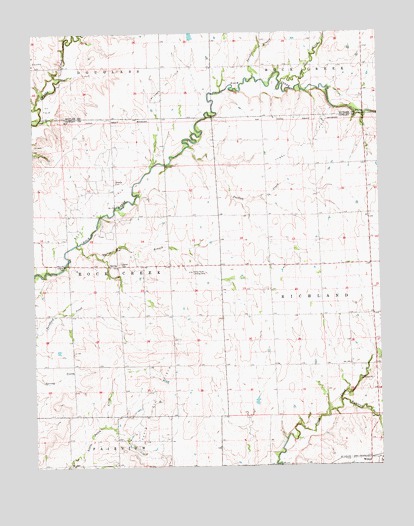
Wilmot, KS USGS Topographic Map
Click on map above to begin viewing in our Map Viewer.

This topographic map contains these locations and features:
Feature Name Type Latitude Longitude GNIS ID View Map
Chigger CreekStreamN37.4847°W96.9034°470011View Map
Combs Oil FieldOilfieldN37.4686°W96.9003°470013View Map
David Oil FieldOilfieldN37.3934°W96.9581°469926View Map
Durham CreekStreamN37.4672°W96.9439°470014View Map
Eaton Acres Landing Strip (historical)AirportN37.4314°W96.9431°470018View Map
Green Valley Church (historical)ChurchN37.4256°W96.9603°483426View Map
Mount Tabor Oil FieldOilfieldN37.4861°W96.9503°470010View Map
Muqbra Muslim CemeteryCemeteryN37.4984°W96.8814°2673224View Map
Prairie Grove School (historical)SchoolN37.3828°W96.9606°483462View Map
Prairie View School (historical)SchoolN37.4472°W96.8795°483466View Map
Richland CreekStreamN37.3939°W96.8895°470030View Map
Richland School (historical)SchoolN37.4036°W96.8989°483470View Map
Rock Oil FieldOilfieldN37.4500°W96.9753°470016View Map
Stalter BranchStreamN37.4386°W96.9850°470021View Map
Stalter CemeteryCemeteryN37.4334°W96.9696°470017View Map
Swisher BranchStreamN37.4870°W96.9203°470012View Map
Township of RichlandCivilN37.4255°W96.8785°470024View Map
Township of Rock CreekCivilN37.4328°W96.9876°470020View Map
Widener CemeteryCemeteryN37.4572°W96.9708°470015View Map
WilmotPopulated PlaceN37.3761°W96.8759°484496View Map

Note: Coordinates in the location and feature list above are referenced to NAD83 datum.


Copyright (C) 2008-2024 Ryan Niemi / Sunset Dynamics ... All Rights Reserved