TopoQuest Logo
Do you find TopoQuest useful?
Help keep TopoQuest running and adding new maps/features by donating!
Bitcoin:  19c7KJd3qBynnjoSw5npx9KScwjBe4ifkT
Litecoin:  LXs6TkuXGGXo1vDsWCkWVdjQX94eUKd6ui
Home View Maps Find Maps Find Places Resources & Links


New Virginia, Iowa Topographic Map

USGS Map Title: New Virginia, IA
USGS Map MRC: 41093B6
DRG (GeoTIFF) Download: o41093b6.tif


Neighboring USGS Topographic Map Quads:


  Saint Charles, IA  
41093C7
 

  Martensdale, IA  
41093C6
 

  Indianola, IA  
41093C5
 

  Truro, IA  
41093B7
 

  New Virginia, IA  
41093B6
 

  Medora, IA  
41093B5
 

  Osceola, IA  
41093A7
 

  Jamison, IA  
41093A6
 

  Woodburn, IA  
41093A5


Map MRC Location:

N42°
W94°
N42°
W93°
H8 H7 H6 H5 H4 H3 H2 H1
G8 G7 G6 G5 G4 G3 G2 G1
F8 F7 F6 F5 F4 F3 F2 F1
E8 E7 E6 E5 E4 E3 E2 E1
D8 D7 D6 D5 D4 D3 D2 D1
C8 C7 C6 C5 C4 C3 C2 C1
B8 B7 B6 B5 B4 B3 B2 B1
A8 A7 A6 A5 A4 A3 A2 A1
N41°
W94°
N41°
W93°

New Virginia, IA USGS 1:24K Topographic Map Preview:
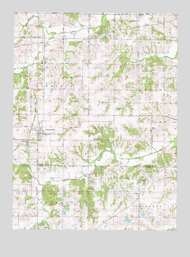
New Virginia, IA USGS Topographic Map
Click on map above to begin viewing in our Map Viewer.

This topographic map contains these locations and features:
Feature Name Type Latitude Longitude GNIS ID View Map
Beymer CemeteryCemeteryN41.1771°W93.7351°1970101View Map
Box Elder CreekStreamN41.2389°W93.7022°1823008View Map
Broadhorn ChurchChurchN41.1806°W93.7308°1970041View Map
Broadhorn CreekStreamN41.2364°W93.7213°454835View Map
City of New VirginiaCivilN41.1816°W93.7310°2395219View Map
Folger Post Office (historical)Post OfficeN41.1431°W93.6863°1969754View Map
Grace Baptist ChurchChurchN41.1844°W93.7288°1970039View Map
Green CemeteryCemeteryN41.1417°W93.7254°1969812View Map
Green Pines Wildlife AreaParkN41.1481°W93.7099°1969742View Map
Interstate Thirty-Five SchoolSchoolN41.1800°W93.7255°1823007View Map
Jamison CemeteryCemeteryN41.1266°W93.7263°1823005View Map
LibertyPopulated PlaceN41.1453°W93.6541°458312View Map
Liberty CemeteryCemeteryN41.1383°W93.6547°458313View Map
Liberty Post Office (historical)Post OfficeN41.1453°W93.6541°1969752View Map
Medford ChurchChurchN41.2455°W93.6558°458945View Map
Mount Tabor CemeteryCemeteryN41.1945°W93.6687°459339View Map
Mount Tabor ChurchChurchN41.1989°W93.6699°459340View Map
Mount Tabor SchoolSchoolN41.1978°W93.6536°459341View Map
New VirginiaPopulated PlaceN41.1822°W93.7288°459495View Map
New Virginia (historical)LocaleN41.1842°W93.7355°1970043View Map
New Virginia Christian ChurchChurchN41.1828°W93.7288°1970040View Map
New Virginia LibraryBuildingN41.1806°W93.7308°1970037View Map
New Virginia Post OfficePost OfficeN41.1806°W93.7308°1970036View Map
New Virginia United Methodist ChurchChurchN41.1806°W93.7308°1970042View Map
Papoose CreekStreamN41.2281°W93.6261°460017View Map
Pleasant View SchoolSchoolN41.1758°W93.6458°460319View Map
Rhodes CemeteryCemeteryN41.1538°W93.6483°1823006View Map
Rolling Thunder PrairieParkN41.2056°W93.6572°1969868View Map
South River Crossing (historical)Populated PlaceN41.2178°W93.7461°464257View Map
Squaw Center SchoolSchoolN41.2050°W93.6266°461931View Map
Township of VirginiaCivilN41.2056°W93.7313°468875View Map
Virginia Township Fire and Rescue DepartmentBuildingN41.1820°W93.7300°1970038View Map
Walnut CreekStreamN41.1500°W93.7266°1823004View Map

Note: Coordinates in the location and feature list above are referenced to NAD83 datum.


Copyright (C) 2008-2025 Ryan Niemi / Sunset Dynamics ... All Rights Reserved