TopoQuest Logo
Do you find TopoQuest useful?
Help keep TopoQuest running and adding new maps/features by donating!
Bitcoin:  19c7KJd3qBynnjoSw5npx9KScwjBe4ifkT
Litecoin:  LXs6TkuXGGXo1vDsWCkWVdjQX94eUKd6ui
Home View Maps Find Maps Find Places Resources & Links


Lyeffion, Alabama Topographic Map

USGS Map Title: Lyeffion, AL
USGS Map MRC: 31086E8
DRG (GeoTIFF) Download: o31086e8.tif


Neighboring USGS Topographic Map Quads:


  Skinnerton, AL  
31087F1
 

  Bethel, AL  
31086F8
 

  Georgiana West, AL  
31086F7
 

  China, AL  
31087E1
 

  Lyeffion, AL  
31086E8
 

  Garland, AL  
31086E7
 

  Belleville, AL  
31087D1
 

  Evergreen, AL  
31086D8
 

  Old Town, AL  
31086D7


Map MRC Location:

N32°
W87°
N32°
W86°
H8 H7 H6 H5 H4 H3 H2 H1
G8 G7 G6 G5 G4 G3 G2 G1
F8 F7 F6 F5 F4 F3 F2 F1
E8 E7 E6 E5 E4 E3 E2 E1
D8 D7 D6 D5 D4 D3 D2 D1
C8 C7 C6 C5 C4 C3 C2 C1
B8 B7 B6 B5 B4 B3 B2 B1
A8 A7 A6 A5 A4 A3 A2 A1
N31°
W87°
N31°
W86°

Lyeffion, AL USGS 1:24K Topographic Map Preview:
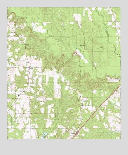
Lyeffion, AL USGS Topographic Map
Click on map above to begin viewing in our Map Viewer.

This topographic map contains these locations and features:
Feature Name Type Latitude Longitude GNIS ID View Map
Antioch ChurchChurchN31.5013°W86.9580°113124View Map
Beasley School (historical)SchoolN31.5404°W86.9194°133088View Map
BowlesPopulated PlaceN31.5735°W86.9769°156101View Map
Bowles ChurchChurchN31.5721°W86.9766°133122View Map
Chestnut Grove Methodist ChurchChurchN31.5982°W86.9086°154105View Map
Conecuh County LakeDamN31.5002°W86.9600°129870View Map
Cooks CrossroadsPopulated PlaceN31.5682°W86.9764°156210View Map
East Sepulga RiverStreamN31.5982°W86.9530°151758View Map
Exit 101CrossingN31.5060°W86.9233°155649View Map
GracePopulated PlaceN31.6121°W86.8805°156423View Map
Hank Williams Memorial ParkParkN31.5960°W86.8778°135017View Map
Holiness Church (historical)ChurchN31.5282°W86.8911°133123View Map
Joyner CemeteryCemeteryN31.6110°W86.9236°149640View Map
Lake ShirleyReservoirN31.5042°W86.9587°153434View Map
Little Pine Level CemeteryCemeteryN31.5893°W86.9152°149642View Map
Little Pine Level ChurchChurchN31.5679°W86.9772°133137View Map
Little Pine Level ChurchChurchN31.5890°W86.9158°121840View Map
LyeffionPopulated PlaceN31.5427°W86.9861°122114View Map
Lyeffion Baptist ChurchChurchN31.5454°W86.9814°133140View Map
Lyeffion Fire DepartmentBuildingN31.5707°W86.9765°2691323View Map
Lyeffion High SchoolSchoolN31.5418°W86.9875°133142View Map
Millieville ChurchChurchN31.5041°W86.9486°122841View Map
Mount Olive West Baptist ChurchChurchN31.6118°W86.8811°155361View Map
Mount Olive West CemeteryCemeteryN31.6107°W86.8808°135779View Map
Mount Zion ChurchChurchN31.5635°W86.9761°123446View Map
New Home ChurchChurchN31.5899°W86.9805°123768View Map
Rogers School (historical)SchoolN31.5988°W86.9083°135414View Map
Second Mount Zion Baptist ChurchChurchN31.5182°W86.9166°126521View Map
Second Mount Zion CemeteryCemeteryN31.5179°W86.9158°1805535View Map
Sepulga Lookout TowerTowerN31.5977°W86.9916°164416View Map
Tomley CreekStreamN31.5074°W86.9536°128012View Map
West Sepulga RiverStreamN31.5982°W86.9530°128799View Map
WilcoxPopulated PlaceN31.5085°W86.8764°157257View Map

Note: Coordinates in the location and feature list above are referenced to NAD83 datum.


Copyright (C) 2008-2025 Ryan Niemi / Sunset Dynamics ... All Rights Reserved