TopoQuest Logo
Do you find TopoQuest useful?
Help keep TopoQuest running and adding new maps/features by donating!
Bitcoin:  19c7KJd3qBynnjoSw5npx9KScwjBe4ifkT
Litecoin:  LXs6TkuXGGXo1vDsWCkWVdjQX94eUKd6ui
Home View Maps Find Maps Find Places Resources & Links


Newellton, Louisiana Topographic Map

USGS Map Title: Newellton, LA
USGS Map MRC: 32091A2
DRG (GeoTIFF) Download: o32091a2.tif


Neighboring USGS Topographic Map Quads:


  Westwood, LA  
32091B3
 

  Somerset, LA  
32091B2
 

  Bedford, LA  
32091B1
 

  Saranac, LA  
32091A3
 

  Newellton, LA  
32091A2
 

  Grand Gulf, MS  
32091A1
 

  Lake Bruin, LA  
31091H3
 

  Saint Joseph, LA  
31091H2
 

  Widows Creek, MS  
31091H1


Map MRC Location:

N33°
W92°
N33°
W91°
H8 H7 H6 H5 H4 H3 H2 H1
G8 G7 G6 G5 G4 G3 G2 G1
F8 F7 F6 F5 F4 F3 F2 F1
E8 E7 E6 E5 E4 E3 E2 E1
D8 D7 D6 D5 D4 D3 D2 D1
C8 C7 C6 C5 C4 C3 C2 C1
B8 B7 B6 B5 B4 B3 B2 B1
A8 A7 A6 A5 A4 A3 A2 A1
N32°
W92°
N32°
W91°

Newellton, LA USGS 1:24K Topographic Map Preview:
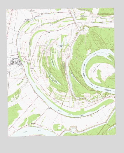
Newellton, LA USGS Topographic Map
Click on map above to begin viewing in our Map Viewer.

This topographic map contains these locations and features:
Feature Name Type Latitude Longitude GNIS ID View Map
Alligator SloughGutN32.0890°W91.2023°532140View Map
BalmoralPopulated PlaceN32.1149°W91.2240°542947View Map
Black RiverStreamN32.0674°W91.2268°533191View Map
Black Water PlantationLocaleN32.0896°W91.2432°549285View Map
Bland CemeteryCemeteryN32.1140°W91.1348°533207View Map
Blue HoleLakeN32.0053°W91.1748°553717View Map
Broadroom ChurchChurchN32.0904°W91.2387°533415View Map
Buck RidgeRidgeN32.1129°W91.1348°549291View Map
Buckridge CrevasseBasinN32.1057°W91.1615°533507View Map
Burn CemeteryCemeteryN32.1154°W91.1259°533561View Map
Canton CemeteryCemeteryN32.1001°W91.2057°533759View Map
Clark BayouGutN32.0427°W91.2371°553997View Map
Delta Dusters, LLC AirportAirportN32.0641°W91.2475°1632868View Map
Elk Ridge CemeteryCemeteryN32.1043°W91.1834°534797View Map
Franklin Spur (historical)LocaleN32.1013°W91.2418°549308View Map
Greenfield ChurchChurchN32.1104°W91.1426°535394View Map
Grudge DitchCanalN32.0363°W91.1840°535436View Map
Hard Times BendBendN32.0702°W91.1604°549313View Map
Hard Times BendBendN32.0518°W91.1548°686774View Map
Hard Times Bend RevetmentLeveeN32.0432°W91.1404°549314View Map
Hopkins PlantationLocaleN32.0299°W91.1673°549318View Map
Jerusalem ChurchChurchN32.1199°W91.1751°536032View Map
Johnson LakeLakeN32.0900°W91.1864°554892View Map
Lake BruinLakeN32.0060°W91.2207°553796View Map
Lake Saint JosephLakeN32.0236°W91.1867°555904View Map
Lemy CemeteryCemeteryN32.1104°W91.1507°536402View Map
Little Flag LakeLakeN32.0722°W91.1978°555070View Map
Little Johnson LakeLakeN32.0562°W91.1951°555077View Map
Lodge LakeLakeN32.0927°W91.1812°555124View Map
Mud LakeLakeN32.0528°W91.1950°555438View Map
NewelltonPopulated PlaceN32.0727°W91.2409°537660View Map
Newellton CemeteryCemeteryN32.0671°W91.2307°537661View Map
Newellton Elementary SchoolSchoolN32.0731°W91.2418°549341View Map
Newellton Police DepartmentBuildingN32.0750°W91.2350°2755252View Map
NotnacPopulated PlaceN32.1032°W91.2023°537759View Map
Parish Governing Authority District 2CivilN32.0710°W91.2470°1929920View Map
Parish Governing Authority District 3CivilN32.0480°W91.1630°1929980View Map
Phelps BayouLakeN32.0522°W91.2348°538100View Map
Pleasant Green ChurchChurchN32.1179°W91.2159°538236View Map
Raritan PlantationLocaleN32.0174°W91.2018°549351View Map
River SticksLakeN32.1129°W91.1912°538620View Map
Routhwood CemeteryCemeteryN32.0663°W91.2307°538755View Map
Ruthwood Elementary SchoolSchoolN32.0715°W91.2390°549355View Map
Saint Antioch CemeteryCemeteryN32.0246°W91.1407°549356View Map
Saint Antioch Church (historical)ChurchN32.0257°W91.1415°549357View Map
Saint Antioch School (historical)SchoolN32.0257°W91.1415°549358View Map
Saint ChurchChurchN32.1113°W91.1273°538824View Map
Saint Luke ChurchChurchN32.1149°W91.1868°538945View Map
Saint Matthew CemeteryCemeteryN32.0277°W91.2007°549365View Map
Saint Matthew ChurchChurchN32.0279°W91.2001°538996View Map
Saint Peter ChurchChurchN32.1235°W91.2201°539049View Map
Solomon ChurchChurchN32.0668°W91.2221°539471View Map
Spurgeon Church (historical)ChurchN32.0213°W91.1498°549369View Map
Tensas CemeteryCemeteryN32.1138°W91.2282°539819View Map
Tensas Parish Fire District 1 Station 1BuildingN32.0744°W91.2355°2672876View Map
Town of NewelltonCivilN32.0724°W91.2391°2406985View Map
Ward ThreeCivilN32.0018°W91.2329°545214View Map
Ward TwoCivilN32.0707°W91.2357°545213View Map
Watermelon LakeLakeN32.0807°W91.1983°556370View Map
White Oak LakeLakeN32.0575°W91.1724°556408View Map
Winter Quarters CrevasseBasinN32.0057°W91.1743°549386View Map
Winter Quarters PlantationLocaleN32.0132°W91.1754°549387View Map
Winter Quarters State Historic SiteParkN32.0132°W91.1754°1946042View Map
Wyoming CemeteryCemeteryN32.1204°W91.2068°540557View Map
Wyoming PlantationLocaleN32.1227°W91.2118°549389View Map
Yucatan LakeLakeN32.0527°W91.1557°556489View Map
Yucatan LandingPopulated PlaceN32.0799°W91.1540°543801View Map
Yucatan PointCapeN32.0665°W91.1465°679978View Map

Note: Coordinates in the location and feature list above are referenced to NAD83 datum.


Copyright (C) 2008-2024 Ryan Niemi / Sunset Dynamics ... All Rights Reserved