TopoQuest Logo
Do you find TopoQuest useful?
Help keep TopoQuest running and adding new maps/features by donating!
Bitcoin:  19c7KJd3qBynnjoSw5npx9KScwjBe4ifkT
Litecoin:  LXs6TkuXGGXo1vDsWCkWVdjQX94eUKd6ui
Home View Maps Find Maps Find Places Resources & Links


Somerset, Louisiana Topographic Map

USGS Map Title: Somerset, LA
USGS Map MRC: 32091B2
DRG (GeoTIFF) Download: o32091b2.tif


Neighboring USGS Topographic Map Quads:


  Waverly SE, LA  
32091C3
 

  Fortune Fork, LA  
32091C2
 

  Mound, LA  
32091C1
 

  Westwood, LA  
32091B3
 

  Somerset, LA  
32091B2
 

  Bedford, LA  
32091B1
 

  Saranac, LA  
32091A3
 

  Newellton, LA  
32091A2
 

  Grand Gulf, MS  
32091A1


Map MRC Location:

N33°
W92°
N33°
W91°
H8 H7 H6 H5 H4 H3 H2 H1
G8 G7 G6 G5 G4 G3 G2 G1
F8 F7 F6 F5 F4 F3 F2 F1
E8 E7 E6 E5 E4 E3 E2 E1
D8 D7 D6 D5 D4 D3 D2 D1
C8 C7 C6 C5 C4 C3 C2 C1
B8 B7 B6 B5 B4 B3 B2 B1
A8 A7 A6 A5 A4 A3 A2 A1
N32°
W92°
N32°
W91°

Somerset, LA USGS 1:24K Topographic Map Preview:
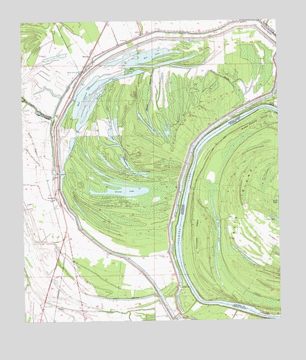
Somerset, LA USGS Topographic Map
Click on map above to begin viewing in our Map Viewer.

This topographic map contains these locations and features:
Feature Name Type Latitude Longitude GNIS ID View Map
AftonPopulated PlaceN32.2449°W91.1915°541043View Map
Allendale CemeteryCemeteryN32.2463°W91.1812°532116View Map
Ashville (historical)Populated PlaceN32.1529°W91.1793°549280View Map
Ashwood LandingLocaleN32.1460°W91.1737°1631089View Map
Bayou du RossetGutN32.1293°W91.2173°532416View Map
Bridgie BayouGutN32.2271°W91.1532°533396View Map
Duck LakeLakeN32.1871°W91.2007°554287View Map
Grassy LakeLakeN32.1787°W91.2036°554595View Map
Hapaca PlanatationLocaleN32.2268°W91.2251°549229View Map
HurricanePopulated PlaceN32.1668°W91.1482°686336View Map
Hurricane IslandAreaN32.1610°W91.1654°671633View Map
Ione PlantationLocaleN32.2132°W91.1571°549321View Map
Lake ShallowLakeN32.1342°W91.2011°556012View Map
Middle Palmyra IslandAreaN32.2085°W91.1340°673532View Map
Mill LakeLakeN32.2360°W91.1865°555321View Map
Mound BayouLakeN32.2227°W91.2096°555384View Map
Mound BayouLakeN32.2046°W91.1868°537275View Map
Mud LakeLakeN32.2310°W91.1635°555439View Map
Negro BayouGutN32.2004°W91.2446°532062View Map
New Carthage (historical)Populated PlaceN32.2140°W91.1259°549519View Map
Palmyra BendBendN32.1335°W91.1640°686366View Map
Palmyra LakeLakeN32.1610°W91.1732°555589View Map
Pasture Green ChurchChurchN32.2288°W91.2221°538003View Map
QuimbyPopulated PlaceN32.2354°W91.2165°543608View Map
Richland PlantationLocaleN32.2393°W91.2209°549261View Map
Saint John CemeteryCemeteryN32.2085°W91.2376°538872View Map
Saint John ChurchChurchN32.1846°W91.2351°538881View Map
Saint Paul ChurchChurchN32.2418°W91.1984°539023View Map
Saint Paul Church (historical)ChurchN32.1565°W91.2104°549366View Map
Snyder CemeteryCemeteryN32.2463°W91.1590°549265View Map
SomersetPopulated PlaceN32.1763°W91.2340°543680View Map
Somerset CemeteryCemeteryN32.1524°W91.1809°539472View Map
Somerset LandingLocaleN32.1565°W91.1762°549367View Map
Somerset PlantationLocaleN32.1490°W91.1940°549368View Map
Woodburn PlantationLocaleN32.1977°W91.1718°549388View Map

Note: Coordinates in the location and feature list above are referenced to NAD83 datum.


Copyright (C) 2008-2024 Ryan Niemi / Sunset Dynamics ... All Rights Reserved