TopoQuest Logo
Do you find TopoQuest useful?
Help keep TopoQuest running and adding new maps/features by donating!
Bitcoin:  19c7KJd3qBynnjoSw5npx9KScwjBe4ifkT
Litecoin:  LXs6TkuXGGXo1vDsWCkWVdjQX94eUKd6ui
Home View Maps Find Maps Find Places Resources & Links


Newtonville, Alabama Topographic Map

USGS Map Title: Newtonville, AL
USGS Map MRC: 33087E7
DRG (GeoTIFF) Download: o33087e7.tif


Neighboring USGS Topographic Map Quads:


  Belk, AL  
33087F8
 

  Fayette, AL  
33087F7
 

  Bankston, AL  
33087F6
 

  Kennedy, AL  
33087E8
 

  Newtonville, AL  
33087E7
 

  New Lexington, AL  
33087E6
 

  Palmetto, AL  
33087D8
 

  Brownville, AL  
33087D7
 

  Gin Creek, AL  
33087D6


Map MRC Location:

N34°
W88°
N34°
W87°
H8 H7 H6 H5 H4 H3 H2 H1
G8 G7 G6 G5 G4 G3 G2 G1
F8 F7 F6 F5 F4 F3 F2 F1
E8 E7 E6 E5 E4 E3 E2 E1
D8 D7 D6 D5 D4 D3 D2 D1
C8 C7 C6 C5 C4 C3 C2 C1
B8 B7 B6 B5 B4 B3 B2 B1
A8 A7 A6 A5 A4 A3 A2 A1
N33°
W88°
N33°
W87°

Newtonville, AL USGS 1:24K Topographic Map Preview:
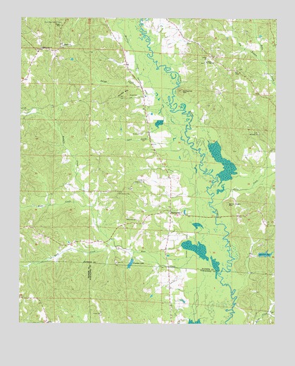
Newtonville, AL USGS Topographic Map
Click on map above to begin viewing in our Map Viewer.

This topographic map contains these locations and features:
Feature Name Type Latitude Longitude GNIS ID View Map
Bear CreekStreamN33.5176°W87.7767°154976View Map
Blakely CreekStreamN33.5482°W87.8403°114479View Map
Blakely Creek Oil FieldOilfieldN33.5687°W87.8472°154889View Map
Brotherton CemeteryCemeteryN33.5776°W87.8150°114976View Map
Cains Ridge Lookout TowerTowerN33.6232°W87.8556°164298View Map
Canaan ChurchChurchN33.6084°W87.7847°115524View Map
Canaan Junior High SchoolSchoolN33.6073°W87.7842°115528View Map
Davis (historical)LocaleN33.5965°W87.8200°137712View Map
Davis CreekStreamN33.5490°W87.7822°117124View Map
Freeman LakeReservoirN33.5246°W87.8207°118627View Map
Freeman Lake DamDamN33.5268°W87.8183°131601View Map
Goat HillSummitN33.6221°W87.8553°119065View Map
Gravlee CemeteryCemeteryN33.5590°W87.8178°119288View Map
Gurley Hughs MountainSummitN33.5487°W87.7733°119511View Map
Jay BranchStreamN33.6068°W87.7556°120824View Map
JerusalemPopulated PlaceN33.6118°W87.8584°158312View Map
Lazy CreekStreamN33.5346°W87.8300°121444View Map
Lynn CreekStreamN33.5801°W87.8078°122122View Map
Martins CreekStreamN33.5887°W87.8020°122342View Map
Mayfield Volunteer Fire DepartmentBuildingN33.5005°W87.8006°2683210View Map
McCracken MountainSummitN33.5957°W87.7967°122499View Map
Mitchum LakeReservoirN33.5288°W87.7550°122911View Map
Mitchum Lake DamDamN33.5268°W87.7583°131600View Map
New Canaan CemeteryCemeteryN33.6068°W87.7847°158492View Map
NewtonvillePopulated PlaceN33.5454°W87.8014°123935View Map
Newtonville Elementary SchoolSchoolN33.5434°W87.8228°165492View Map
Newtonville Gas FieldOilfieldN33.5607°W87.8111°154913View Map
Old Canaan CemeteryCemeteryN33.5784°W87.7589°158493View Map
Old Canaan ChurchChurchN33.5779°W87.7581°124203View Map
Old Shepherd CemeteryCemeteryN33.5532°W87.8270°124251View Map
Palestine CemeteryCemeteryN33.6132°W87.8542°158489View Map
Palestine ChurchChurchN33.6137°W87.8542°124385View Map
Pilgrim Rest CemeteryCemeteryN33.6123°W87.8656°158319View Map
Pilgrims Rest Baptist ChurchChurchN33.6129°W87.8650°152905View Map
Savage CemeteryCemeteryN33.5937°W87.8220°126430View Map
Savage CreekStreamN33.5993°W87.8120°126431View Map
Savage MountainSummitN33.5943°W87.8245°126434View Map
Shady Grove CemeteryCemeteryN33.5576°W87.8192°158490View Map
Shady Grove ChurchChurchN33.5582°W87.8189°126611View Map
Shepherd Baptist ChurchChurchN33.5454°W87.8017°163209View Map
Shepherd CemeteryCemeteryN33.5454°W87.8017°158491View Map
Stone Wall Volunteer Fire DepartmentBuildingN33.6093°W87.7812°2683035View Map
Walnut Lane (historical)LocaleN33.5934°W87.8161°137781View Map
Walnut Lane Volunteer Fire DepartmentBuildingN33.5864°W87.8141°2683383View Map
Wright CemeteryCemeteryN33.5682°W87.8331°158326View Map
Zion Chapel CemeteryCemeteryN33.6045°W87.7681°158327View Map
Zion Chapel Methodist ChurchChurchN33.6034°W87.7700°158963View Map

Note: Coordinates in the location and feature list above are referenced to NAD83 datum.


Copyright (C) 2008-2025 Ryan Niemi / Sunset Dynamics ... All Rights Reserved