TopoQuest Logo
Do you find TopoQuest useful?
Help keep TopoQuest running and adding new maps/features by donating!
Bitcoin:  19c7KJd3qBynnjoSw5npx9KScwjBe4ifkT
Litecoin:  LXs6TkuXGGXo1vDsWCkWVdjQX94eUKd6ui
Home View Maps Find Maps Find Places Resources & Links


Kennedy, Alabama Topographic Map

USGS Map Title: Kennedy, AL
USGS Map MRC: 33087E8
DRG (GeoTIFF) Download: o33087e8.tif


Neighboring USGS Topographic Map Quads:


  Hightogy, AL  
33088F1
 

  Belk, AL  
33087F8
 

  Fayette, AL  
33087F7
 

  Millport, AL  
33088E1
 

  Kennedy, AL  
33087E8
 

  Newtonville, AL  
33087E7
 

  Reform, AL  
33088D1
 

  Palmetto, AL  
33087D8
 

  Brownville, AL  
33087D7


Map MRC Location:

N34°
W88°
N34°
W87°
H8 H7 H6 H5 H4 H3 H2 H1
G8 G7 G6 G5 G4 G3 G2 G1
F8 F7 F6 F5 F4 F3 F2 F1
E8 E7 E6 E5 E4 E3 E2 E1
D8 D7 D6 D5 D4 D3 D2 D1
C8 C7 C6 C5 C4 C3 C2 C1
B8 B7 B6 B5 B4 B3 B2 B1
A8 A7 A6 A5 A4 A3 A2 A1
N33°
W88°
N33°
W87°

Kennedy, AL USGS 1:24K Topographic Map Preview:
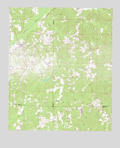
Kennedy, AL USGS Topographic Map
Click on map above to begin viewing in our Map Viewer.

This topographic map contains these locations and features:
Feature Name Type Latitude Longitude GNIS ID View Map
Asbury Post Office (historical)Post OfficeN33.5723°W87.9520°166010View Map
Ashcraft CornerPopulated PlaceN33.5268°W87.9006°137685View Map
Ashcraft Corner Baptist ChurchChurchN33.5271°W87.9009°113249View Map
Ashcraft Corner CemeteryCemeteryN33.5287°W87.9006°158496View Map
Brown CemeteryCemeteryN33.5590°W87.8936°114989View Map
Chapel Hill Baptist ChurchChurchN33.5382°W87.8800°115959View Map
Chapel Hill CemeteryCemeteryN33.5373°W87.8786°158495View Map
Dorroh CemeteryCemeteryN33.5215°W87.9884°117387View Map
Harmony Primitive Baptist ChurchChurchN33.6187°W87.9361°119753View Map
Higdon ChurchChurchN33.5573°W87.9942°120048View Map
Higdon Memorial CemeteryCemeteryN33.5573°W87.9945°158447View Map
KennedyPopulated PlaceN33.5871°W87.9845°121145View Map
Kennedy CemeteryCemeteryN33.5829°W87.9814°158448View Map
Kennedy High SchoolSchoolN33.5884°W87.9881°132779View Map
Kennedy Post OfficePost OfficeN33.5868°W87.9849°166646View Map
Kennedy Volunteer Fire DepartmentBuildingN33.5860°W87.9861°2682863View Map
Little Coal Fire CreekStreamN33.5162°W87.9820°121737View Map
Lubbub Creek Gas FieldOilfieldN33.5098°W87.9250°154849View Map
Mill CreekStreamN33.6023°W87.9784°122794View Map
Moore CemeteryCemeteryN33.6121°W87.9272°158314View Map
Moore CemeteryCemeteryN33.6073°W87.9528°122998View Map
Mount Zion CemeteryCemeteryN33.5243°W87.8992°163234View Map
Mount Zion ChurchChurchN33.5246°W87.8989°123481View Map
New Wesley Chapel CemeteryCemeteryN33.5293°W87.9381°158497View Map
Oak Ridge Baptist ChurchChurchN33.5823°W87.9011°152746View Map
Oak Ridge CemeteryCemeteryN33.5823°W87.9000°158494View Map
Owens CemeteryCemeteryN33.5943°W87.8953°124344View Map
Pilgrim Church (historical)ChurchN33.6221°W87.9200°137762View Map
Riverside ChurchChurchN33.6057°W87.9992°125671View Map
Rock Curve ChurchChurchN33.5862°W87.9700°125764View Map
Sanders CemeteryCemeteryN33.5582°W87.9206°126341View Map
Summers CemeteryCemeteryN33.5621°W87.9067°127540View Map
Thompson CemeteryCemeteryN33.5462°W87.9859°127894View Map
Town of KennedyCivilN33.5809°W87.9862°2405936View Map
Wesley Chapel Methodist ChurchChurchN33.5301°W87.9384°158952View Map
WHKW-FM (Fayette)TowerN33.5754°W87.9909°161201View Map
Wilson CemeteryCemeteryN33.5432°W87.9461°158959View Map
Wilson CemeteryCemeteryN33.5690°W87.9522°158960View Map
Wilson CemeteryCemeteryN33.5815°W87.9531°158482View Map
Wilson ChurchChurchN33.5812°W87.9528°129078View Map

Note: Coordinates in the location and feature list above are referenced to NAD83 datum.


Copyright (C) 2008-2025 Ryan Niemi / Sunset Dynamics ... All Rights Reserved