TopoQuest Logo
Do you find TopoQuest useful?
Help keep TopoQuest running and adding new maps/features by donating!
Bitcoin:  19c7KJd3qBynnjoSw5npx9KScwjBe4ifkT
Litecoin:  LXs6TkuXGGXo1vDsWCkWVdjQX94eUKd6ui
Home View Maps Find Maps Find Places Resources & Links


Neyles, South Carolina Topographic Map

USGS Map Title: Neyles, SC
USGS Map MRC: 32080G5
DRG (GeoTIFF) Download: o32080g5.tif


Neighboring USGS Topographic Map Quads:


  Walterboro, SC  
32080H6
 

  Round O, SC  
32080H5
 

  Cottageville, SC  
32080H4
 

  Hendersonville, SC  
32080G6
 

  Neyles, SC  
32080G5
 

  Jacksonboro, SC  
32080G4
 

  White Hall, SC  
32080F6
 

  Green Pond, SC  
32080F5
 

  Fenwick, SC  
32080F4


Map MRC Location:

N33°
W81°
N33°
W80°
H8 H7 H6 H5 H4 H3 H2 H1
G8 G7 G6 G5 G4 G3 G2 G1
F8 F7 F6 F5 F4 F3 F2 F1
E8 E7 E6 E5 E4 E3 E2 E1
D8 D7 D6 D5 D4 D3 D2 D1
C8 C7 C6 C5 C4 C3 C2 C1
B8 B7 B6 B5 B4 B3 B2 B1
A8 A7 A6 A5 A4 A3 A2 A1
N32°
W81°
N32°
W80°

Neyles, SC USGS 1:24K Topographic Map Preview:
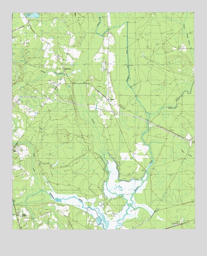
Neyles, SC USGS Topographic Map
Click on map above to begin viewing in our Map Viewer.

This topographic map contains these locations and features:
Feature Name Type Latitude Longitude GNIS ID View Map
Aimwell ChurchChurchN32.8257°W80.5587°1240541View Map
Ashepoo CrossingPopulated PlaceN32.7577°W80.6190°1231014View Map
Chessey CreekStreamN32.7646°W80.5440°1247274View Map
Colleton Fire Department Station 12BuildingN32.8298°W80.5666°2368320View Map
Colleton Fire Department Station 30BuildingN32.7872°W80.5617°2578732View Map
Cumberland ChurchChurchN32.7960°W80.6245°1247463View Map
DrawdyPopulated PlaceN32.8480°W80.6248°1231238View Map
Horseshoe BridgeBridgeN32.8135°W80.5315°1223345View Map
Isaiah ChurchChurchN32.8277°W80.6018°1246130View Map
Ivanhoe BridgeBridgeN32.7655°W80.6182°1223475View Map
Johno CreekStreamN32.7721°W80.6057°1223590View Map
Mashawville SchoolSchoolN32.8602°W80.6015°1224362View Map
NeylesPopulated PlaceN32.8252°W80.5584°1249870View Map
Neyles School (historical)SchoolN32.8257°W80.5595°1240688View Map
Neyles School (historical)SchoolN32.8316°W80.5593°1240689View Map
Pendergrass Cross RoadsLocaleN32.8013°W80.5029°1240700View Map
Price BridgeBridgeN32.7843°W80.5320°1250240View Map
Pringle BendPopulated PlaceN32.8480°W80.5879°1250247View Map
Pringle CreekStreamN32.8399°W80.5807°1225676View Map
Saint Johns ChurchChurchN32.8346°W80.5920°1240730View Map
Saint Marks ChurchChurchN32.7991°W80.5029°1226192View Map
Saint Pauls ChurchChurchN32.8221°W80.6048°1250652View Map
Saint Peters ChurchChurchN32.8730°W80.6145°1226253View Map
Saint Peters School (historical)SchoolN32.8716°W80.6140°1240733View Map
Salem Church (historical)ChurchN32.7582°W80.6215°1240734View Map
Sandy Dam BranchStreamN32.8655°W80.5643°1226361View Map
Tupelo SwampSwampN32.7927°W80.5054°1227229View Map
Wards Cross School (historical)SchoolN32.8307°W80.5962°1240775View Map
Whitehouse PlantationLocaleN32.7532°W80.5707°1240785View Map

Note: Coordinates in the location and feature list above are referenced to NAD83 datum.


Copyright (C) 2008-2024 Ryan Niemi / Sunset Dynamics ... All Rights Reserved