TopoQuest Logo
Do you find TopoQuest useful?
Help keep TopoQuest running and adding new maps/features by donating!
Bitcoin:  19c7KJd3qBynnjoSw5npx9KScwjBe4ifkT
Litecoin:  LXs6TkuXGGXo1vDsWCkWVdjQX94eUKd6ui
Home View Maps Find Maps Find Places Resources & Links


Round O, South Carolina Topographic Map

USGS Map Title: Round O, SC
USGS Map MRC: 32080H5
DRG (GeoTIFF) Download: o32080h5.tif


Neighboring USGS Topographic Map Quads:


  Saint George SW, SC  
33080A6
 

  Canadys, SC  
33080A5
 

  Maple Cane Swamp, SC  
33080A4
 

  Walterboro, SC  
32080H6
 

  Round O, SC  
32080H5
 

  Cottageville, SC  
32080H4
 

  Hendersonville, SC  
32080G6
 

  Neyles, SC  
32080G5
 

  Jacksonboro, SC  
32080G4


Map MRC Location:

N33°
W81°
N33°
W80°
H8 H7 H6 H5 H4 H3 H2 H1
G8 G7 G6 G5 G4 G3 G2 G1
F8 F7 F6 F5 F4 F3 F2 F1
E8 E7 E6 E5 E4 E3 E2 E1
D8 D7 D6 D5 D4 D3 D2 D1
C8 C7 C6 C5 C4 C3 C2 C1
B8 B7 B6 B5 B4 B3 B2 B1
A8 A7 A6 A5 A4 A3 A2 A1
N32°
W81°
N32°
W80°

Round O, SC USGS 1:24K Topographic Map Preview:
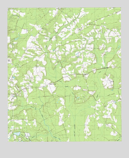
Round O, SC USGS Topographic Map
Click on map above to begin viewing in our Map Viewer.

This topographic map contains these locations and features:
Feature Name Type Latitude Longitude GNIS ID View Map
Allen CreekStreamN32.9904°W80.6243°1227779View Map
Bedons Baptist ChurchChurchN32.9199°W80.6140°1240549View Map
Bedons School (historical)SchoolN32.9221°W80.6123°1245031View Map
Bethel ChurchChurchN32.9632°W80.6040°1220548View Map
Bethlehem ChurchChurchN32.9627°W80.5423°1240563View Map
Bethlehem SchoolSchoolN32.9632°W80.5423°1220622View Map
Bethlehem School (historical)SchoolN32.9599°W80.5432°1240561View Map
Burr HillPopulated PlaceN32.9316°W80.5132°1221146View Map
Burr Hill School (historical)SchoolN32.9243°W80.5029°1240573View Map
Calvary ChurchChurchN32.8985°W80.5148°1221215View Map
Canaan ChurchChurchN32.9302°W80.5379°1221292View Map
Davis HillPopulated PlaceN32.9179°W80.5426°1231212View Map
Drigger CrossroadsPopulated PlaceN32.9291°W80.5801°1222096View Map
Fishbourne Reservoir D-2386 DamDamN32.8802°W80.6098°1239397View Map
Fishburne PlantationLocaleN32.8996°W80.5315°1240620View Map
Fuller SchoolSchoolN32.8985°W80.5668°1222603View Map
Fuller Swamp CreekStreamN32.9046°W80.5520°1247848View Map
Hall SchoolSchoolN32.9913°W80.5557°1222988View Map
HiottsPopulated PlaceN32.9788°W80.5445°1240644View Map
Holiness Tabernacle ChurchChurchN32.9521°W80.6115°1240645View Map
Koger SchoolSchoolN32.9738°W80.5951°1223769View Map
Lake LuciousReservoirN32.8827°W80.6143°1238811View Map
Little Rock School (historical)SchoolN32.9916°W80.5554°1240667View Map
Mount Sina ChurchChurchN32.9071°W80.5179°1224795View Map
Northside Elementary SchoolSchoolN32.9484°W80.6162°2486546View Map
Old Bethel School (historical)SchoolN32.9632°W80.6034°1240693View Map
Peoples ChurchChurchN32.9716°W80.5968°1240705View Map
Peoples SchoolSchoolN32.9388°W80.6209°1225368View Map
Reservoir PondReservoirN32.8817°W80.6090°1239398View Map
Round OPopulated PlaceN32.9371°W80.5409°1226044View Map
Round O Post OfficePost OfficeN32.9371°W80.5399°2489881View Map
Sandy Dam ChurchChurchN32.8807°W80.6193°1250763View Map
Shereau BranchStreamN32.8810°W80.5759°1226560View Map
SidneyPopulated PlaceN32.9996°W80.5684°1227981View Map
Snipe SchoolSchoolN32.8910°W80.5182°1226723View Map
Snipe School (historical)SchoolN32.9074°W80.5176°1240750View Map
South Carolina Noname 15007 D-2384 DamDamN32.8818°W80.6165°1238810View Map
South Carolina Noname 15008 D-2385 DamDamN32.8752°W80.6115°1238812View Map
Welch Green School (historical)SchoolN32.9618°W80.6048°1240778View Map
Wesley ChurchChurchN32.9846°W80.5334°1251371View Map
Wesley School (historical)SchoolN32.9849°W80.5340°1240780View Map

Note: Coordinates in the location and feature list above are referenced to NAD83 datum.


Copyright (C) 2008-2025 Ryan Niemi / Sunset Dynamics ... All Rights Reserved