TopoQuest Logo
Do you find TopoQuest useful?
Help keep TopoQuest running and adding new maps/features by donating!
Bitcoin:  19c7KJd3qBynnjoSw5npx9KScwjBe4ifkT
Litecoin:  LXs6TkuXGGXo1vDsWCkWVdjQX94eUKd6ui
Home View Maps Find Maps Find Places Resources & Links


Nicholson, Mississippi Topographic Map

USGS Map Title: Nicholson, MS
USGS Map MRC: 30089D6
DRG (GeoTIFF) Download: o30089d6.tif


Neighboring USGS Topographic Map Quads:


  Industrial, MS  
30089E7
 

  Picayune, MS  
30089E6
 

  Caesar, MS  
30089E5
 

  Hickory, LA  
30089D7
 

  Nicholson, MS  
30089D6
 

  Dead Tiger Creek, MS  
30089D5
 

  Slidell, LA  
30089C7
 

  Haaswood, LA  
30089C6
 

  Logtown, MS  
30089C5


Map MRC Location:

N31°
W90°
N31°
W89°
H8 H7 H6 H5 H4 H3 H2 H1
G8 G7 G6 G5 G4 G3 G2 G1
F8 F7 F6 F5 F4 F3 F2 F1
E8 E7 E6 E5 E4 E3 E2 E1
D8 D7 D6 D5 D4 D3 D2 D1
C8 C7 C6 C5 C4 C3 C2 C1
B8 B7 B6 B5 B4 B3 B2 B1
A8 A7 A6 A5 A4 A3 A2 A1
N30°
W90°
N30°
W89°

Nicholson, MS USGS 1:24K Topographic Map Preview:
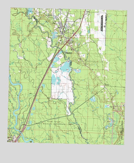
Nicholson, MS USGS Topographic Map
Click on map above to begin viewing in our Map Viewer.

This topographic map contains these locations and features:
Feature Name Type Latitude Longitude GNIS ID View Map
Aaron AcademySchoolN30.4316°W89.6462°710450View Map
Alligator BranchStreamN30.4546°W89.6856°666226View Map
Bilbo LakeLakeN30.3787°W89.7300°560195View Map
Bings Ferry (historical)CrossingN30.4749°W89.7240°710154View Map
Black BayouStreamN30.4691°W89.7342°560207View Map
Broadaxe BayouStreamN30.4049°W89.7428°560278View Map
Cedar Grove ChurchChurchN30.4627°W89.6828°668193View Map
Clear BayouStreamN30.4271°W89.7184°560439View Map
Corinth ChurchChurchN30.4099°W89.6362°668827View Map
Crooked BayouStreamN30.4630°W89.7451°560542View Map
Current RiverStreamN30.3980°W89.7473°560555View Map
Dry BayouStreamN30.4138°W89.7070°560655View Map
Emanuel Baptist ChurchChurchN30.4780°W89.6911°2596992View Map
Gum CreekStreamN30.3882°W89.7498°560921View Map
Indian BayouStreamN30.3830°W89.6706°1627323View Map
Indian Camp BranchStreamN30.4466°W89.6687°671673View Map
Interchange 1CrossingN30.4696°W89.6878°691469View Map
Interchange 11CrossingN30.4613°W89.6965°1628677View Map
Interchange 5ACrossingN30.3769°W89.7406°1628675View Map
Interchange 5BCrossingN30.3891°W89.7320°1628676View Map
Interstate 59 Welcome CenterBuildingN30.4973°W89.6691°2596434View Map
Jackson LandingLocaleN30.4752°W89.7237°688131View Map
Jackson Landing Road ChurchChurchN30.4932°W89.7092°1965986View Map
Jesus Name Apostolic ChurchChurchN30.3756°W89.7449°2602093View Map
Johns BayouStreamN30.4157°W89.6970°1627363View Map
Lindsey LakeLakeN30.4134°W89.7371°1627484View Map
Little Indian BayouStreamN30.4338°W89.7242°1627520View Map
Macks IslandIslandN30.4002°W89.6612°689416View Map
Magnolia Personal Care HomeBuildingN30.4722°W89.6956°2596181View Map
McCall RiverGutN30.4830°W89.7106°673290View Map
Middle BayouStreamN30.4141°W89.7431°1627643View Map
Mill CreekStreamN30.4874°W89.7203°673614View Map
Murdock Eddy LakeLakeN30.3943°W89.6778°1627737View Map
Murdocks EddyBayN30.3941°W89.6767°689515View Map
Murphy BayouStreamN30.4066°W89.6845°1627738View Map
NicholsonPopulated PlaceN30.4771°W89.6937°674919View Map
Nicholson Census Designated PlaceCensusN30.4861°W89.6996°2586607View Map
Nicholson Elementary SchoolSchoolN30.4797°W89.6911°710161View Map
Nicholson First Baptist ChurchChurchN30.4788°W89.6955°2597114View Map
Nicholson Post OfficePost OfficeN30.4793°W89.6950°2768849View Map
Nicholson Volunteer Fire DepartmentBuildingN30.4730°W89.6900°2332794View Map
Oak Ridge ChurchChurchN30.4538°W89.6731°675093View Map
Old ChannelStreamN30.3794°W89.7337°1627820View Map
Old Palestine ChurchChurchN30.4869°W89.7012°1965989View Map
Old RiverStreamN30.4046°W89.7445°1627832View Map
Oldfield BayouStreamN30.3830°W89.7381°1627835View Map
Open Swamp BayouStreamN30.3785°W89.7017°1627841View Map
Pearl BayouStreamN30.3935°W89.7353°1627884View Map
Pearl RiverPopulated PlaceN30.3760°W89.7484°1627886View Map
Pearl River CemeteryCemeteryN30.3777°W89.7492°1628992View Map
Pearl River Municipal Sewage Treatment PlantLocaleN30.3808°W89.7430°2603491View Map
Pearl River Police DepartmentBuildingN30.3754°W89.7464°2333953View Map
Pearl River State Wildlife Management AreaParkN30.3941°W89.7009°1965991View Map
Picayune Municipal AirportAirportN30.4944°W89.6536°680301View Map
Proctor Plantation (historical)LocaleN30.4627°W89.6778°710166View Map
Red Hill ChurchChurchN30.4866°W89.7015°676532View Map
Rones BayouStreamN30.4130°W89.6845°1628071View Map
Santa RosaPopulated PlaceN30.4296°W89.6478°677401View Map
Seaburn House BayouStreamN30.3780°W89.7034°1628193View Map
Second Alligator BranchStreamN30.4452°W89.6823°677488View Map
Starks BayouStreamN30.3980°W89.7473°1628291View Map
Stockstill LakeLakeN30.3757°W89.7220°1628296View Map
Supervisor District 4CivilN30.4810°W89.6873°712024View Map
The DeltaAreaN30.4099°W89.6792°689431View Map
Turkey BayouStreamN30.4299°W89.7390°1628390View Map
Turkey LakeLakeN30.4309°W89.7408°1628392View Map
Turtleskin CemeteryCemeteryN30.4116°W89.6373°678987View Map
Turtleskin CreekStreamN30.3916°W89.6462°678988View Map
West Indian BayouStreamN30.4488°W89.7437°1628474View Map
Willow Bend Mobile Home ParkPopulated PlaceN30.4723°W89.6969°2596510View Map
Yellow BayouStreamN30.3863°W89.7376°1628538View Map

Note: Coordinates in the location and feature list above are referenced to NAD83 datum.


Copyright (C) 2008-2025 Ryan Niemi / Sunset Dynamics ... All Rights Reserved