TopoQuest Logo
Do you find TopoQuest useful?
Help keep TopoQuest running and adding new maps/features by donating!
Bitcoin:  19c7KJd3qBynnjoSw5npx9KScwjBe4ifkT
Litecoin:  LXs6TkuXGGXo1vDsWCkWVdjQX94eUKd6ui
Home View Maps Find Maps Find Places Resources & Links


Danvers, Illinois Topographic Map

USGS Map Title: Danvers, IL
USGS Map MRC: 40089E2
DRG (GeoTIFF) Download: o40089e2.tif


Neighboring USGS Topographic Map Quads:


  Eureka, IL  
40089F3
 

  Secor, IL  
40089F2
 

  El Paso, IL  
40089F1
 

  Mackinaw, IL  
40089E3
 

  Danvers, IL  
40089E2
 

  Normal West, IL  
40089E1
 

  Minier, IL  
40089D3
 

  Stanford, IL  
40089D2
 

  Bloomington West, IL  
40089D1


Map MRC Location:

N41°
W90°
N41°
W89°
H8 H7 H6 H5 H4 H3 H2 H1
G8 G7 G6 G5 G4 G3 G2 G1
F8 F7 F6 F5 F4 F3 F2 F1
E8 E7 E6 E5 E4 E3 E2 E1
D8 D7 D6 D5 D4 D3 D2 D1
C8 C7 C6 C5 C4 C3 C2 C1
B8 B7 B6 B5 B4 B3 B2 B1
A8 A7 A6 A5 A4 A3 A2 A1
N40°
W90°
N40°
W89°

Danvers, IL USGS 1:24K Topographic Map Preview:
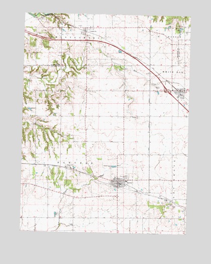
Danvers, IL USGS Topographic Map
Click on map above to begin viewing in our Map Viewer.

This topographic map contains these locations and features:
Feature Name Type Latitude Longitude GNIS ID View Map
Barwell LakeReservoirN40.6173°W89.1327°403951View Map
Barwell Lake DamDamN40.6181°W89.1326°1691375View Map
CarlockPopulated PlaceN40.5823°W89.1320°405596View Map
Carlock Elementary SchoolSchoolN40.5825°W89.1379°1822426View Map
Carlock Fire Protection DistrictBuildingN40.5839°W89.1369°2682476View Map
Carlock Post OfficePost OfficeN40.5825°W89.1315°2788754View Map
CongervillePopulated PlaceN40.6170°W89.2043°406464View Map
Congerville ChurchChurchN40.6214°W89.2393°406465View Map
Congerville Elementary SchoolSchoolN40.6175°W89.2004°1824262View Map
Congerville Fire Protection DistrictBuildingN40.6169°W89.1987°2640780View Map
Congerville Post OfficePost OfficeN40.6160°W89.2047°2788667View Map
Crescent School (historical)SchoolN40.5681°W89.1276°1747550View Map
Cross LakeReservoirN40.5700°W89.2445°1691318View Map
Cross Lake DamDamN40.5700°W89.2468°1691317View Map
DanversPopulated PlaceN40.5295°W89.1773°406948View Map
Danvers Community Fire Protection DistrictBuildingN40.5280°W89.1754°2682371View Map
Danvers Elementary SchoolSchoolN40.5300°W89.1709°1822445View Map
Danvers Emergency and Rescue ServiceBuildingN40.5280°W89.1754°2673800View Map
Danvers Post OfficePost OfficeN40.5284°W89.1767°2788767View Map
Dement School (historical)SchoolN40.5064°W89.2101°1747555View Map
Evergreen CemeteryCemeteryN40.5375°W89.2151°419197View Map
Farmsville (historical)Populated PlaceN40.6209°W89.2398°1824273View Map
Fifer School (historical)SchoolN40.5511°W89.2395°1747570View Map
Fluegel BridgeBridgeN40.5039°W89.2101°424896View Map
Franks School (historical)SchoolN40.5631°W89.2023°1747572View Map
Habecker BridgeBridgeN40.5317°W89.1915°424956View Map
Hall-Barnard CemeteryCemeteryN40.5167°W89.1356°403904View Map
Hickory Ridge School (historical)SchoolN40.5198°W89.1551°1747583View Map
Imhoff CemeteryCemeteryN40.5950°W89.2032°410775View Map
Interchange 120CrossingN40.5823°W89.1417°1822504View Map
Mackinaw DellsPopulated PlaceN40.6239°W89.2309°422928View Map
Maurer CemeteryCemeteryN40.5969°W89.1888°1952866View Map
Mitchell School (historical)SchoolN40.5267°W89.2481°1747610View Map
North Carlock School (historical)SchoolN40.6067°W89.1384°1802010View Map
North Danvers CemeteryCemeteryN40.5667°W89.1626°1952867View Map
North Danvers ChurchChurchN40.5667°W89.1634°414585View Map
Oak Grove CemeteryCemeteryN40.6158°W89.1289°414776View Map
Park Lawn CemeteryCemeteryN40.5323°W89.1712°415384View Map
Rock Creek School (historical)SchoolN40.5923°W89.1742°1747621View Map
Sears LakeReservoirN40.5550°W89.2218°1691310View Map
Sears Lake DamDamN40.5550°W89.2218°1691309View Map
Stouts Grove School (historical)SchoolN40.5348°W89.2095°1747636View Map
Strubhar School (historical)SchoolN40.5884°W89.2123°1747637View Map
Swamp School (historical)SchoolN40.5559°W89.1729°1747639View Map
Township of DanversCivilN40.5409°W89.2108°428872View Map
Village of CarlockCivilN40.5836°W89.1289°2397556View Map
Village of CongervilleCivilN40.6168°W89.2052°2398616View Map
Village of DanversCivilN40.5298°W89.1753°2398681View Map
White Oak CemeteryCemeteryN40.6188°W89.1315°421048View Map
Wintz CemeteryCemeteryN40.5838°W89.1476°420712View Map
WoodruffPopulated PlaceN40.5381°W89.2315°1747650View Map

Note: Coordinates in the location and feature list above are referenced to NAD83 datum.


Copyright (C) 2008-2024 Ryan Niemi / Sunset Dynamics ... All Rights Reserved