TopoQuest Logo
Do you find TopoQuest useful?
Help keep TopoQuest running and adding new maps/features by donating!
Bitcoin:  19c7KJd3qBynnjoSw5npx9KScwjBe4ifkT
Litecoin:  LXs6TkuXGGXo1vDsWCkWVdjQX94eUKd6ui
Home View Maps Find Maps Find Places Resources & Links


Secor, Illinois Topographic Map

USGS Map Title: Secor, IL
USGS Map MRC: 40089F2
DRG (GeoTIFF) Download: o40089f2.tif


Neighboring USGS Topographic Map Quads:


  Metamora, IL  
40089G3
 

  Roanoke, IL  
40089G2
 

  Benson, IL  
40089G1
 

  Eureka, IL  
40089F3
 

  Secor, IL  
40089F2
 

  El Paso, IL  
40089F1
 

  Mackinaw, IL  
40089E3
 

  Danvers, IL  
40089E2
 

  Normal West, IL  
40089E1


Map MRC Location:

N41°
W90°
N41°
W89°
H8 H7 H6 H5 H4 H3 H2 H1
G8 G7 G6 G5 G4 G3 G2 G1
F8 F7 F6 F5 F4 F3 F2 F1
E8 E7 E6 E5 E4 E3 E2 E1
D8 D7 D6 D5 D4 D3 D2 D1
C8 C7 C6 C5 C4 C3 C2 C1
B8 B7 B6 B5 B4 B3 B2 B1
A8 A7 A6 A5 A4 A3 A2 A1
N40°
W90°
N40°
W89°

Secor, IL USGS 1:24K Topographic Map Preview:
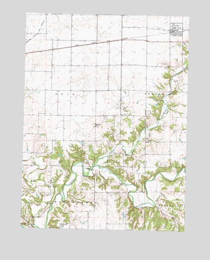
Secor, IL USGS Topographic Map
Click on map above to begin viewing in our Map Viewer.

This topographic map contains these locations and features:
Feature Name Type Latitude Longitude GNIS ID View Map
Bowling Green (historical)Populated PlaceN40.6631°W89.1729°1824255View Map
Dells Apostolic Christian CemeteryCemeteryN40.6309°W89.2418°403568View Map
Denman CreekStreamN40.6417°W89.1490°407123View Map
Harvey School (historical)SchoolN40.7223°W89.1854°1801996View Map
Mennonite CemeteryCemeteryN40.6859°W89.1953°413402View Map
Meridian School (historical)SchoolN40.7131°W89.1576°1802007View Map
Nichols MoundSummitN40.6386°W89.2287°414510View Map
Panther CreekStreamN40.6611°W89.1965°415347View Map
Panther Creek School (historical)SchoolN40.6909°W89.1884°1802016View Map
Price School (historical)SchoolN40.7339°W89.2298°1802023View Map
Red RiverStreamN40.6725°W89.1798°416464View Map
Ridgetop Hill Prairie Nature PreserveParkN40.6517°W89.1626°2013482View Map
Robenstein BridgeBridgeN40.6598°W89.1976°425390View Map
Rock Quarry School (historical)SchoolN40.6689°W89.2270°1802028View Map
Saint Johns Lutheran ChurchChurchN40.7434°W89.1365°1824290View Map
SecorPopulated PlaceN40.7420°W89.1354°418176View Map
Secor CemeteryCemeteryN40.7349°W89.1252°418177View Map
Secor Church of ChristChurchN40.7425°W89.1387°1824293View Map
Secor Community Fire Protection DistrictBuildingN40.7414°W89.1376°2640623View Map
Secor Post OfficePost OfficeN40.7414°W89.1371°2788775View Map
Secor United Methodist ChurchChurchN40.7384°W89.1365°1824294View Map
Township of MontgomeryCivilN40.6305°W89.2365°429389View Map
Township of OlioCivilN40.7062°W89.2265°429486View Map
Union School (historical)SchoolN40.6675°W89.1559°1802041View Map
Versailles School (historical)SchoolN40.6920°W89.2340°1802043View Map
Village of SecorCivilN40.7418°W89.1350°2399782View Map
Vincent RunStreamN40.6400°W89.1476°420320View Map
Walnut CreekStreamN40.6256°W89.2395°420445View Map
White Oak LakeReservoirN40.6262°W89.2199°421054View Map
WYZZ-TV (Bloomington)TowerN40.6459°W89.1792°428327View Map

Note: Coordinates in the location and feature list above are referenced to NAD83 datum.


Copyright (C) 2008-2025 Ryan Niemi / Sunset Dynamics ... All Rights Reserved