TopoQuest Logo
Do you find TopoQuest useful?
Help keep TopoQuest running and adding new maps/features by donating!
Bitcoin:  19c7KJd3qBynnjoSw5npx9KScwjBe4ifkT
Litecoin:  LXs6TkuXGGXo1vDsWCkWVdjQX94eUKd6ui
Home View Maps Find Maps Find Places Resources & Links


Belmont, Indiana Topographic Map

USGS Map Title: Belmont, IN
USGS Map MRC: 39086B3
DRG (GeoTIFF) Download: o39086b3.tif


Neighboring USGS Topographic Map Quads:


  Hindustan, IN  
39086C4
 

  Morgantown, IN  
39086C3
 

  Beanblossom, IN  
39086C2
 

  Unionville, IN  
39086B4
 

  Belmont, IN  
39086B3
 

  Nashville, IN  
39086B2
 

  Allens Creek, IN  
39086A4
 

  Elkinsville, IN  
39086A3
 

  Story, IN  
39086A2


Map MRC Location:

N40°
W87°
N40°
W86°
H8 H7 H6 H5 H4 H3 H2 H1
G8 G7 G6 G5 G4 G3 G2 G1
F8 F7 F6 F5 F4 F3 F2 F1
E8 E7 E6 E5 E4 E3 E2 E1
D8 D7 D6 D5 D4 D3 D2 D1
C8 C7 C6 C5 C4 C3 C2 C1
B8 B7 B6 B5 B4 B3 B2 B1
A8 A7 A6 A5 A4 A3 A2 A1
N39°
W87°
N39°
W86°

Belmont, IN USGS 1:24K Topographic Map Preview:
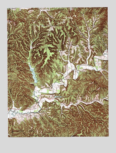
Belmont, IN USGS Topographic Map
Click on map above to begin viewing in our Map Viewer.

This topographic map contains these locations and features:
Feature Name Type Latitude Longitude GNIS ID View Map
Annandale EstatesPopulated PlaceN39.2178°W86.2661°430181View Map
Annandale Estates LakeReservoirN39.2189°W86.2649°447731View Map
Annandale Estates Lake DamDamN39.2195°W86.2633°447730View Map
Baker HillSummitN39.2462°W86.2980°430434View Map
Bartlett HollowValleyN39.1526°W86.3671°430546View Map
Bartley RidgeRidgeN39.1284°W86.3272°430547View Map
Baughman HillSummitN39.2409°W86.2964°430587View Map
BelmontPopulated PlaceN39.1520°W86.3472°430784View Map
Berry Farm Lake DamDamN39.1884°W86.2517°447246View Map
Bill Jack RidgeRidgeN39.1845°W86.3503°431075View Map
Bradley RidgeRidgeN39.1484°W86.3158°431439View Map
Bucker KnobSummitN39.1262°W86.3380°431740View Map
Caldwell HollowValleyN39.1676°W86.3437°431951View Map
Davis BranchStreamN39.1470°W86.3478°433341View Map
Dry BranchStreamN39.1559°W86.3086°433700View Map
Dubois RidgeRidgeN39.2081°W86.3239°433740View Map
Dug HillSummitN39.2312°W86.2567°433756View Map
Duncan ChurchChurchN39.1653°W86.3192°433772View Map
Duvall RidgeRidgeN39.1664°W86.3150°433820View Map
East Branch Owl CreekStreamN39.2262°W86.2742°433867View Map
Ferris RidgeRidgeN39.1334°W86.3630°434461View Map
Gold Well HollowValleyN39.1598°W86.2844°435154View Map
Goldenrod PointCapeN39.2117°W86.3144°435159View Map
Graveyard HollowValleyN39.1530°W86.2997°435363View Map
Green Valley CreekStreamN39.1884°W86.2636°435417View Map
Harden HollowValleyN39.2056°W86.2562°435726View Map
Hickory FlatFlatN39.2470°W86.2725°436100View Map
Hickory Hill CemeteryCemeteryN39.1648°W86.2947°436106View Map
High King HillSummitN39.1748°W86.3442°436142View Map
Hobbs HollowValleyN39.1886°W86.2592°436262View Map
Honeycut HollowValleyN39.1459°W86.3438°436398View Map
House BranchStreamN39.1812°W86.2908°436522View Map
Howard RidgeRidgeN39.2364°W86.3639°436545View Map
Jackson BranchStreamN39.2048°W86.2519°436879View Map
John Floyd HollowValleyN39.1904°W86.3438°437018View Map
Kelley HillSummitN39.1778°W86.2689°437218View Map
Kleindorfer HollowValleyN39.1477°W86.3350°437374View Map
LanamPopulated PlaceN39.2337°W86.3275°437588View Map
Lanam Ridge CemeteryCemeteryN39.2321°W86.3141°1946198View Map
Lee Brown RidgeRidgeN39.2278°W86.2942°437730View Map
Lick CreekStreamN39.1898°W86.2944°437860View Map
Low GapGapN39.2484°W86.2858°438352View Map
Lower Schooner CreekStreamN39.1581°W86.3364°438371View Map
Maple HillSummitN39.2331°W86.3178°438563View Map
Mill RidgeRidgeN39.1695°W86.3569°439172View Map
Mossop RidgeRidgeN39.1334°W86.3092°439505View Map
NashvillePopulated PlaceN39.2073°W86.2511°439943View Map
Oak Farm Post Office (historical)Post OfficeN39.2328°W86.3258°453002View Map
Oak Grove ChurchChurchN39.2137°W86.2964°440421View Map
Owl CreekStreamN39.1942°W86.2780°440803View Map
Pattys Garden RidgeRidgeN39.2264°W86.3269°440938View Map
Pine BluffCliffN39.1881°W86.2650°441149View Map
Polecat RidgeRidgeN39.2259°W86.3044°441403View Map
Possum HollowValleyN39.2143°W86.2967°441480View Map
Reverand Frame LakeReservoirN39.2034°W86.2767°447733View Map
Reverand Frame Lake DamDamN39.2034°W86.2767°447732View Map
Scarce of Fat RidgeRidgeN39.2059°W86.3675°443057View Map
Sciscoe BranchStreamN39.1981°W86.2980°443131View Map
Sol Pogue HollowValleyN39.1975°W86.3547°443753View Map
Somerset LakeReservoirN39.1636°W86.3126°443766View Map
Somerset Lake DamDamN39.1628°W86.3175°447279View Map
South View CemeteryCemeteryN39.2098°W86.2505°443865View Map
Sugarcamp HollowValleyN39.2077°W86.3109°451521View Map
TC Steele State MemorialParkN39.1312°W86.3483°444531View Map
Township of WashingtonCivilN39.1658°W86.2618°453984View Map
Upper Schooner CreekStreamN39.1570°W86.2892°445171View Map
Watton HillSummitN39.2137°W86.2669°445558View Map
West Branch Owl CreekStreamN39.2159°W86.2739°445723View Map
West OverlookPopulated PlaceN39.1714°W86.2547°445796View Map
White RidgeRidgeN39.2248°W86.3555°445954View Map
Wise HollowValleyN39.1569°W86.2881°446209View Map
Wolfpen BranchStreamN39.1492°W86.3369°446262View Map
Yellowwood LakeReservoirN39.1849°W86.3424°446389View Map
Yellowwood State ForestForestN39.2050°W86.3458°451648View Map

Note: Coordinates in the location and feature list above are referenced to NAD83 datum.


Copyright (C) 2008-2024 Ryan Niemi / Sunset Dynamics ... All Rights Reserved