TopoQuest Logo
Do you find TopoQuest useful?
Help keep TopoQuest running and adding new maps/features by donating!
Bitcoin:  19c7KJd3qBynnjoSw5npx9KScwjBe4ifkT
Litecoin:  LXs6TkuXGGXo1vDsWCkWVdjQX94eUKd6ui
Home View Maps Find Maps Find Places Resources & Links


Rock Creek, Oregon Topographic Map

USGS Map Title: Rock Creek, OR
USGS Map MRC: 44118H1
DRG (GeoTIFF) Download: o44118h1.tif


Neighboring USGS Topographic Map Quads:


  Anthony Butte, OR  
45118A2
 

  Tucker Flat, OR  
45118A1
 

  North Powder, OR  
45117A8
 

  Anthony Lakes, OR  
44118H2
 

  Rock Creek, OR  
44118H1
 

  Haines, OR  
44117H8
 

  Bourne, OR  
44118G2
 

  Elkhorn Peak, OR  
44118G1
 

  Wingville, OR  
44117G8


Map MRC Location:

N45°
W119°
N45°
W118°
H8 H7 H6 H5 H4 H3 H2 H1
G8 G7 G6 G5 G4 G3 G2 G1
F8 F7 F6 F5 F4 F3 F2 F1
E8 E7 E6 E5 E4 E3 E2 E1
D8 D7 D6 D5 D4 D3 D2 D1
C8 C7 C6 C5 C4 C3 C2 C1
B8 B7 B6 B5 B4 B3 B2 B1
A8 A7 A6 A5 A4 A3 A2 A1
N44°
W119°
N44°
W118°

Rock Creek, OR USGS 1:24K Topographic Map Preview:
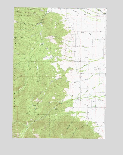
Rock Creek, OR USGS Topographic Map
Click on map above to begin viewing in our Map Viewer.

This topographic map contains these locations and features:
Feature Name Type Latitude Longitude GNIS ID View Map
Antelope PeakSummitN44.9724°W118.0716°1116984View Map
Antone CreekStreamN44.9862°W118.0894°1117014View Map
Badsky PondLakeN44.9034°W118.0939°1117142View Map
Blume Zilkey DitchCanalN44.9635°W118.0341°1117875View Map
Brown Loennig DitchCanalN44.9054°W118.0230°1118129View Map
Bulger DitchCanalN44.9646°W118.0505°1118265View Map
Bulger FlatFlatN44.9551°W118.0788°1118266View Map
Bulger HillSummitN44.9535°W118.0702°1118267View Map
Clapp MeadowFlatN44.9426°W118.0922°1118962View Map
Clear CreekStreamN44.9215°W118.0799°1118993View Map
Dutch Flat CreekStreamN44.9696°W118.0874°1120233View Map
Dutch Flat Creek TrailheadLocaleN44.9618°W118.1177°1167272View Map
Fannie MeadowsFlatN44.9654°W118.0858°1120620View Map
Fisher Hot SpringsSpringN44.9746°W118.0446°1120776View Map
Ford Ingram DitchCanalN44.8943°W118.0963°1120877View Map
Gardner Mill Race DitchCanalN44.9943°W118.0511°1121061View Map
Gorham GulchValleyN44.9893°W118.0869°1121264View Map
Haines Fire Protection District Muddy Creek RoadBuildingN44.9374°W118.0143°2576776View Map
Haines Pond Number TwoLakeN44.9054°W118.0170°1121511View Map
Hart SpringSpringN44.9811°W118.0510°1121640View Map
Hutchinson DitchCanalN44.9857°W118.0488°1122173View Map
Jimmy CreekStreamN44.9371°W118.1069°1122430View Map
Killamacue CreekStreamN44.8863°W118.1036°1122729View Map
Killamacue TrailheadLocaleN44.9549°W118.1077°1167271View Map
Lawrence CreekStreamN44.9521°W118.0999°1123002View Map
Little Antone CreekStreamN44.9835°W118.0924°1123123View Map
Locken MeadowFlatN44.9063°W118.0983°1123332View Map
Lower Fisher Long DitchCanalN44.9221°W118.0241°1123563View Map
Mansfield DitchCanalN44.9488°W118.0208°1123735View Map
Marble CreekStreamN44.8904°W118.0141°1123752View Map
Maxwell DitchCanalN44.9301°W118.0083°1123856View Map
Miller DitchCanalN44.9257°W118.0102°1124196View Map
Mount Carmel (historical)LocaleN44.9996°W118.0386°1130899View Map
Muddy Creek AirportAirportN44.9388°W118.0138°1131646View Map
Muddy Creek School (historical)SchoolN44.9371°W118.0341°1124507View Map
Penstock Olsen DitchCanalN44.9207°W118.0511°1125294View Map
Powers DitchCanalN44.9976°W118.0772°1125644View Map
Rock CreekPopulated PlaceN44.9140°W118.0358°1136696View Map
Rock Creek PowerplantLocaleN44.9093°W118.0624°1126178View Map
Rock Creek ReservoirReservoirN44.9038°W118.0687°1126183View Map
Rockcreek Post Office (historical)Post OfficeN44.9140°W118.0358°1165871View Map
Rocky Ford CampgroundLocaleN44.9857°W118.0891°1126237View Map
Sackos PondReservoirN44.8855°W118.0080°1130898View Map
Snowslide CanyonValleyN44.8957°W118.0424°1127172View Map
Upper Fisher Long DitchCanalN44.9218°W118.0344°1128450View Map
Warfield MeadowFlatN44.9609°W118.0808°1128638View Map
Wilcox DitchCanalN44.9057°W118.0466°1158553View Map
Williams DitchCanalN44.9526°W118.0186°1129118View Map
Wingville-Haines DivisionCivilN44.8762°W118.0554°1938157View Map
Yankey SawmillLocaleN44.9301°W118.0930°1129355View Map

Note: Coordinates in the location and feature list above are referenced to NAD83 datum.


Copyright (C) 2008-2024 Ryan Niemi / Sunset Dynamics ... All Rights Reserved