TopoQuest Logo
Do you find TopoQuest useful?
Help keep TopoQuest running and adding new maps/features by donating!
Bitcoin:  19c7KJd3qBynnjoSw5npx9KScwjBe4ifkT
Litecoin:  LXs6TkuXGGXo1vDsWCkWVdjQX94eUKd6ui
Home View Maps Find Maps Find Places Resources & Links


Oak Mound Bayou, Louisiana Topographic Map

USGS Map Title: Oak Mound Bayou, LA
USGS Map MRC: 29089H3
DRG (GeoTIFF) Download: o29089h3.tif


Neighboring USGS Topographic Map Quads:


  Malheureux Point, LA  
30089A4
 

  Three Mile Bay, LA  
30089A3
 

  Door Point, LA  
30089A2
 

  Lake Eugenie, LA  
29089H4
 

  Oak Mound Bayou, LA  
29089H3
 

  Mitchell Island, LA  
29089H2
 

  Lake Eloi, LA  
29089G4
 

  Morgan Harbor, LA  
29089G3


Map MRC Location:

N30°
W90°
N30°
W89°
H8 H7 H6 H5 H4 H3 H2 H1
G8 G7 G6 G5 G4 G3 G2 G1
F8 F7 F6 F5 F4 F3 F2 F1
E8 E7 E6 E5 E4 E3 E2 E1
D8 D7 D6 D5 D4 D3 D2 D1
C8 C7 C6 C5 C4 C3 C2 C1
B8 B7 B6 B5 B4 B3 B2 B1
A8 A7 A6 A5 A4 A3 A2 A1
N29°
W90°
N29°
W89°

Oak Mound Bayou, LA USGS 1:24K Topographic Map Preview:
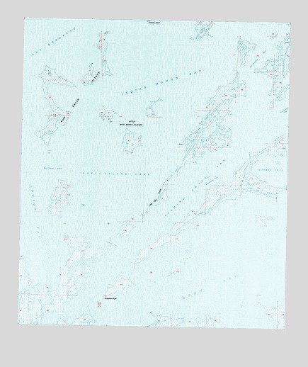
Oak Mound Bayou, LA USGS Topographic Map
Click on map above to begin viewing in our Map Viewer.

This topographic map contains these locations and features:
Feature Name Type Latitude Longitude GNIS ID View Map
Anderson PointCapeN29.8858°W89.3356°559779View Map
Bay BoudreauBayN29.9933°W89.3656°559837View Map
Bayou De SotoBayN29.8886°W89.3696°559930View Map
Bayou TobaccoGutN29.8849°W89.3589°560094View Map
Catfish PassChannelN29.9085°W89.3334°560381View Map
Conkey CoveBayN29.9410°W89.2525°1629515View Map
Conkey Cove PassChannelN29.9427°W89.2678°560461View Map
Deadmans BayouGutN29.9235°W89.2862°560609View Map
Drum BayBayN29.9044°W89.2737°1629517View Map
Dutchman PassChannelN29.9383°W89.3589°560677View Map
Fishing Smack BayBayN29.9330°W89.2948°560750View Map
Hell Pass CoastBeachN29.9274°W89.3109°560952View Map
Indian Mound BayBayN29.9799°W89.3114°1627325View Map
Kerchimbo BayBayN29.9852°W89.2659°1627398View Map
Lawson BayBayN29.9205°W89.3700°1627457View Map
Little Mud Grass IslandsIslandN29.9549°W89.3250°1627528View Map
Live Oak BayouGutN29.9308°W89.2537°1629522View Map
Mud Grass IslandsIslandN29.9746°W89.3625°1627726View Map
Oak Mound BayouGutN29.9580°W89.2895°1627811View Map
Parish Governing Authority District ECivilN29.9040°W89.2943°1930321View Map
Saint Bernard ParishCivilN29.9047°W89.3041°1629542View Map
Shell Island LakeLakeN29.9346°W89.3303°1628217View Map
Southwest PassChannelN29.9352°W89.2856°1628269View Map

Note: Coordinates in the location and feature list above are referenced to NAD83 datum.


Copyright (C) 2008-2025 Ryan Niemi / Sunset Dynamics ... All Rights Reserved