TopoQuest Logo
Do you find TopoQuest useful?
Help keep TopoQuest running and adding new maps/features by donating!
Bitcoin:  19c7KJd3qBynnjoSw5npx9KScwjBe4ifkT
Litecoin:  LXs6TkuXGGXo1vDsWCkWVdjQX94eUKd6ui
Home View Maps Find Maps Find Places Resources & Links


Oil City, Pennsylvania Topographic Map

USGS Map Title: Oil City, PA
USGS Map MRC: 41079D6
DRG (GeoTIFF) Download: o41079d6.tif


Neighboring USGS Topographic Map Quads:


  Dempseytown, PA  
41079E7
 

  Titusville South, PA  
41079E6
 

  Pleasantville, PA  
41079E5
 

  Franklin, PA  
41079D7
 

  Oil City, PA  
41079D6
 

  President, PA  
41079D5
 

  Kennerdell, PA  
41079C7
 

  Cranberry, PA  
41079C6
 

  Kossuth, PA  
41079C5


Map MRC Location:

N42°
W80°
N42°
W79°
H8 H7 H6 H5 H4 H3 H2 H1
G8 G7 G6 G5 G4 G3 G2 G1
F8 F7 F6 F5 F4 F3 F2 F1
E8 E7 E6 E5 E4 E3 E2 E1
D8 D7 D6 D5 D4 D3 D2 D1
C8 C7 C6 C5 C4 C3 C2 C1
B8 B7 B6 B5 B4 B3 B2 B1
A8 A7 A6 A5 A4 A3 A2 A1
N41°
W80°
N41°
W79°

Oil City, PA USGS 1:24K Topographic Map Preview:
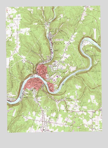
Oil City, PA USGS Topographic Map
Click on map above to begin viewing in our Map Viewer.

This topographic map contains these locations and features:
Feature Name Type Latitude Longitude GNIS ID View Map
AhrensvillePopulated PlaceN41.4545°W79.6456°1198324View Map
Alcorn IslandIslandN41.4223°W79.6773°1198327View Map
Assumption SchoolSchoolN41.4426°W79.7017°1198339View Map
Borough of RousevilleCivilN41.4704°W79.6847°1215642View Map
Calaboose RunStreamN41.4520°W79.7051°1198515View Map
Calvary CemeteryCemeteryN41.4296°W79.6789°1198518View Map
Carney RunStreamN41.4320°W79.6651°1198543View Map
Charley RunStreamN41.4264°W79.7256°1198559View Map
Cherry RunStreamN41.4678°W79.6928°1198562View Map
Cherrytree RunStreamN41.4812°W79.6948°1198563View Map
City of Oil CityCivilN41.4281°W79.7036°1215639View Map
Colonial VillagePopulated PlaceN41.4439°W79.6848°1198592View Map
Cornplanter Municipal BuildingBuildingN41.4498°W79.6767°1198602View Map
Cornplanter RunStreamN41.4442°W79.6987°1198603View Map
Cornplanter Volunteer Fire DepartmentBuildingN41.4489°W79.6770°2644767View Map
Cranberry Area High SchoolSchoolN41.3770°W79.7017°1198615View Map
Darvassy Airport (historical)AirportN41.3951°W79.6645°1194227View Map
Foster HillSummitN41.4892°W79.7328°1198761View Map
Foster Hill School (historical)SchoolN41.4887°W79.7428°1200649View Map
Fosters CornerPopulated PlaceN41.4745°W79.7345°1198763View Map
Gay Street SchoolSchoolN41.4398°W79.6995°1198789View Map
GrandviewPopulated PlaceN41.4670°W79.6642°1198817View Map
Grant Street SchoolSchoolN41.4239°W79.7028°1198818View Map
Grove Hill CemeteryCemeteryN41.4314°W79.6950°1198846View Map
Hasson HeightsPopulated PlaceN41.4489°W79.6770°1867494View Map
Hasson Heights Census Designated PlaceCensusN41.4486°W79.6766°2389909View Map
Hasson Heights Elementary SchoolSchoolN41.4414°W79.6851°1213855View Map
Hoag HillSummitN41.4014°W79.6595°1198892View Map
Hoag Hill ChurchChurchN41.3978°W79.6614°1200647View Map
Holiday RunStreamN41.4387°W79.7142°1198900View Map
Horse CreekStreamN41.4320°W79.6601°1198913View Map
Innis Street SchoolSchoolN41.4251°W79.7184°1198926View Map
Lamb RunStreamN41.4356°W79.6556°1199893View Map
Lamey CemeteryCemeteryN41.4920°W79.7453°1198991View Map
Lamey ChurchChurchN41.4892°W79.7428°1198992View Map
Lincoln Junior High SchoolSchoolN41.4328°W79.7023°1199040View Map
McClintockPopulated PlaceN41.4562°W79.6884°1199128View Map
Mount Pleasant CemeteryCemeteryN41.4131°W79.7153°1199201View Map
Oil CityPopulated PlaceN41.4339°W79.7064°1213995View Map
Oil City Fire Department Station 1 HeadquartersBuildingN41.4248°W79.7105°2644929View Map
Oil City Fire Department Station 3BuildingN41.4363°W79.7019°2645396View Map
Oil City Junior High SchoolSchoolN41.4267°W79.6873°1205658View Map
Oil City Police DepartmentBuildingN41.4331°W79.7080°2780202View Map
Oil City Post OfficePost OfficeN41.4281°W79.7064°2779700View Map
Oil City Senior High SchoolSchoolN41.4303°W79.6831°1205657View Map
Oil CreekStreamN41.4317°W79.7092°1199246View Map
Oliver ManorPopulated PlaceN41.4351°W79.6787°1199250View Map
Panther RunStreamN41.4403°W79.6367°1199273View Map
Pin Oak SchoolSchoolN41.4056°W79.7098°1199303View Map
PlumerPopulated PlaceN41.4992°W79.6417°1199320View Map
Plumer Fire TowerTowerN41.4834°W79.6364°1212143View Map
Reno StationLocaleN41.4073°W79.7489°1212141View Map
RockmereLocaleN41.4392°W79.6623°1212142View Map
RockmerePopulated PlaceN41.4314°W79.6592°1199405View Map
Rose GardensPopulated PlaceN41.4101°W79.6720°1199413View Map
Rossman SchoolSchoolN41.4534°W79.7423°1200648View Map
RousevillePopulated PlaceN41.4689°W79.6909°1199423View Map
Rouseville Post OfficePost OfficeN41.4693°W79.6902°2779872View Map
Rouseville Volunteer Fire DepartmentBuildingN41.4686°W79.6900°2645002View Map
Rynd FarmPopulated PlaceN41.4826°W79.6948°1199429View Map
Sage RunStreamN41.4234°W79.6989°1199434View Map
Saint Josephs CemeteryCemeteryN41.4298°W79.6959°1199444View Map
Saint Josephs SchoolSchoolN41.4351°W79.7031°1199447View Map
Saint Stephen ChurchChurchN41.4287°W79.7089°1199469View Map
Saint Stephen SchoolSchoolN41.4259°W79.7139°1199470View Map
SenecaPopulated PlaceN41.3787°W79.7039°1199506View Map
Seneca Census Designated PlaceCensusN41.3770°W79.7073°2390274View Map
Seneca Post OfficePost OfficeN41.3782°W79.7016°2779590View Map
Seneca Volunteer Fire DepartmentBuildingN41.3890°W79.7027°2645391View Map
Seventh Street Elementary SchoolSchoolN41.4223°W79.7120°1213910View Map
Shaw Farm CemeteryCemeteryN41.4592°W79.6695°1199517View Map
SiverlyPopulated PlaceN41.4206°W79.6934°1199544View Map
Slate RunStreamN41.4226°W79.6467°1199549View Map
Stanleys CornerPopulated PlaceN41.3951°W79.6373°1199591View Map
Steffee Elementary SchoolSchoolN41.3881°W79.6942°1213917View Map
TipperyPopulated PlaceN41.3776°W79.6373°1199685View Map
Tippery SchoolSchoolN41.3876°W79.6381°1199686View Map
Township of CornplanterCivilN41.4901°W79.6546°1217142View Map
University of Pennsylvania Medical Center Northwest SenecaBuildingN41.4279°W79.6957°2718014View Map
Venango CampusSchoolN41.4101°W79.7284°1199725View Map
Venango High SchoolSchoolN41.4137°W79.7248°1199726View Map
Walnut BendBendN41.4628°W79.6487°1199738View Map
Wanango Country ClubLocaleN41.4128°W79.7498°1213394View Map
Wolf BranchStreamN41.4195°W79.6251°1199802View Map
Woodland HeightsPopulated PlaceN41.4098°W79.7117°1199812View Map
Woodland Heights Census Designated PlaceCensusN41.4109°W79.7048°2390530View Map
WOYL-AM (Oil City)TowerN41.4178°W79.7145°1200503View Map
WRJS-FM (Oil City)TowerN41.4178°W79.7145°1200309View Map
Wykle RunStreamN41.4834°W79.6964°1199819View Map

Note: Coordinates in the location and feature list above are referenced to NAD83 datum.


Copyright (C) 2008-2025 Ryan Niemi / Sunset Dynamics ... All Rights Reserved