TopoQuest Logo
Do you find TopoQuest useful?
Help keep TopoQuest running and adding new maps/features by donating!
Bitcoin:  19c7KJd3qBynnjoSw5npx9KScwjBe4ifkT
Litecoin:  LXs6TkuXGGXo1vDsWCkWVdjQX94eUKd6ui
Home View Maps Find Maps Find Places Resources & Links


Titusville South, Pennsylvania Topographic Map

USGS Map Title: Titusville South, PA
USGS Map MRC: 41079E6
DRG (GeoTIFF) Download: o41079e6.tif


Neighboring USGS Topographic Map Quads:


  Centerville, PA  
41079F7
 

  Titusville North, PA  
41079F6
 

  Grand Valley, PA  
41079F5
 

  Dempseytown, PA  
41079E7
 

  Titusville South, PA  
41079E6
 

  Pleasantville, PA  
41079E5
 

  Franklin, PA  
41079D7
 

  Oil City, PA  
41079D6
 

  President, PA  
41079D5


Map MRC Location:

N42°
W80°
N42°
W79°
H8 H7 H6 H5 H4 H3 H2 H1
G8 G7 G6 G5 G4 G3 G2 G1
F8 F7 F6 F5 F4 F3 F2 F1
E8 E7 E6 E5 E4 E3 E2 E1
D8 D7 D6 D5 D4 D3 D2 D1
C8 C7 C6 C5 C4 C3 C2 C1
B8 B7 B6 B5 B4 B3 B2 B1
A8 A7 A6 A5 A4 A3 A2 A1
N41°
W80°
N41°
W79°

Titusville South, PA USGS 1:24K Topographic Map Preview:
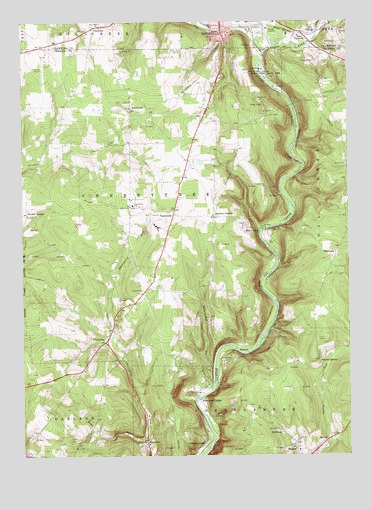
Titusville South, PA USGS Topographic Map
Click on map above to begin viewing in our Map Viewer.

This topographic map contains these locations and features:
Feature Name Type Latitude Longitude GNIS ID View Map
Bates HollowValleyN41.6224°W79.6429°1168804View Map
Benninghof RunStreamN41.5659°W79.6837°1169256View Map
BoughtonLocaleN41.5951°W79.6431°1201009View Map
BreedtownPopulated PlaceN41.6001°W79.7078°1203143View Map
CherrytreePopulated PlaceN41.5328°W79.7184°1171689View Map
Cherrytree SchoolSchoolN41.5723°W79.7070°1171690View Map
Cherrytree Township Volunteer Fire DepartmentBuildingN41.5740°W79.7086°2644939View Map
Church RunStreamN41.6239°W79.6612°1171864View Map
Columbia FarmLocaleN41.5045°W79.6798°1172246View Map
Cross Creek Resort Golf CourseLocaleN41.5695°W79.7006°1206137View Map
Drake Oil WellWellN41.6109°W79.6570°1173448View Map
Drake Well State ParkParkN41.6114°W79.6548°1173451View Map
Dutch Hill SchoolSchoolN41.6109°W79.6678°1201005View Map
East TitusvillePopulated PlaceN41.6220°W79.6423°1173886View Map
EmergyCare Titusville Department 34BuildingN41.6228°W79.6755°2719681View Map
GreshamPopulated PlaceN41.6237°W79.7198°1176216View Map
Husband RunStreamN41.5726°W79.6470°1212149View Map
Jameson CornersLocaleN41.5689°W79.6759°1177978View Map
Kane RunStreamN41.5051°W79.7020°1178215View Map
KanevillePopulated PlaceN41.5042°W79.7026°1178217View Map
Kerr Hill ChurchChurchN41.6239°W79.7201°1178406View Map
Mason Farm CornersLocaleN41.5487°W79.6778°1212148View Map
Miller FarmLocaleN41.5667°W79.6642°1181215View Map
Oakland ChurchChurchN41.5048°W79.7306°1201012View Map
Oil Creek State ParkParkN41.5417°W79.6498°1198247View Map
Oil SeepsSpringN41.5292°W79.6681°1201324View Map
OwltownPopulated PlaceN41.5073°W79.6514°1204345View Map
Petroleum CenterPopulated PlaceN41.5162°W79.6823°1204386View Map
Pine CreekStreamN41.6181°W79.6528°1183779View Map
PioneerPopulated PlaceN41.5312°W79.6651°1204410View Map
Prather CornersLocaleN41.5695°W79.7481°1184382View Map
Prather SchoolSchoolN41.5689°W79.7462°1201013View Map
Redfield SchoolSchoolN41.6031°W79.6345°1201008View Map
Rose SchoolSchoolN41.5492°W79.6781°1201011View Map
Russell CornersLocaleN41.5276°W79.6362°1185648View Map
ShamburgPopulated PlaceN41.5601°W79.6284°1204621View Map
Shreve SchoolSchoolN41.5826°W79.6753°1201010View Map
Shriver AirportAirportN41.6068°W79.6835°1194262View Map
Titusville AirportAirportN41.6119°W79.7400°1194261View Map
ToonervillePopulated PlaceN41.5698°W79.6909°1204818View Map
Township of CherrytreeCivilN41.5742°W79.7085°1217140View Map
WTIV-AM (Titusville)TowerN41.6176°W79.6926°1200510View Map
Zerrer SchoolSchoolN41.6045°W79.6826°1201007View Map

Note: Coordinates in the location and feature list above are referenced to NAD83 datum.


Copyright (C) 2008-2024 Ryan Niemi / Sunset Dynamics ... All Rights Reserved