TopoQuest Logo
Do you find TopoQuest useful?
Help keep TopoQuest running and adding new maps/features by donating!
Bitcoin:  19c7KJd3qBynnjoSw5npx9KScwjBe4ifkT
Litecoin:  LXs6TkuXGGXo1vDsWCkWVdjQX94eUKd6ui
Home View Maps Find Maps Find Places Resources & Links


Old Washington, Ohio Topographic Map

USGS Map Title: Old Washington, OH
USGS Map MRC: 40081A4
DRG (GeoTIFF) Download: o40081a4.tif


Neighboring USGS Topographic Map Quads:


  Kimbolton, OH  
40081B5
 

  Birmingham, OH  
40081B4
 

  Freeport, OH  
40081B3
 

  Cambridge, OH  
40081A5
 

  Old Washington, OH  
40081A4
 

  Antrim, OH  
40081A3
 

  Byesville, OH  
39081H5
 

  Senecaville, OH  
39081H4
 

  Quaker City, OH  
39081H3


Map MRC Location:

N41°
W82°
N41°
W81°
H8 H7 H6 H5 H4 H3 H2 H1
G8 G7 G6 G5 G4 G3 G2 G1
F8 F7 F6 F5 F4 F3 F2 F1
E8 E7 E6 E5 E4 E3 E2 E1
D8 D7 D6 D5 D4 D3 D2 D1
C8 C7 C6 C5 C4 C3 C2 C1
B8 B7 B6 B5 B4 B3 B2 B1
A8 A7 A6 A5 A4 A3 A2 A1
N40°
W82°
N40°
W81°

Old Washington, OH USGS 1:24K Topographic Map Preview:
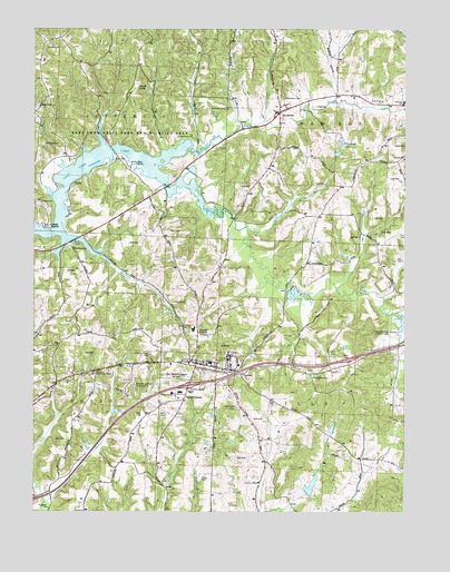
Old Washington, OH USGS Topographic Map
Click on map above to begin viewing in our Map Viewer.

This topographic map contains these locations and features:
Feature Name Type Latitude Longitude GNIS ID View Map
Allen CemeteryCemeteryN40.0912°W81.4732°1037367View Map
Allen Chapel (historical)ChurchN40.0909°W81.4735°1054732View Map
Beeham RunStreamN40.0720°W81.4943°1037807View Map
BradyPopulated PlaceN40.0859°W81.4857°1062659View Map
Brady Post Office (historical)Post OfficeN40.0862°W81.4860°1988771View Map
Brothers AviationAirportN40.0337°W81.4664°1082918View Map
Brushy ForkStreamN40.0895°W81.4579°1038432View Map
Brushy Fork Church (historical)ChurchN40.0845°W81.3926°1054726View Map
Buckeye Trail High SchoolSchoolN40.0387°W81.4404°1054729View Map
Butternut DairyLocaleN40.0978°W81.4025°2704747View Map
Christian CreekStreamN40.1009°W81.4221°1039092View Map
Coon RunStreamN40.0728°W81.4273°1039348View Map
Crossroads School (historical)SchoolN40.0826°W81.4590°1054733View Map
Deep Cut School (historical)SchoolN40.0359°W81.4790°1054735View Map
Devils KnobSummitN40.1101°W81.4654°1048660View Map
EastonPopulated PlaceN40.0359°W81.4293°1048684View Map
ElizabethtownPopulated PlaceN40.0359°W81.4065°1048701View Map
Elizabethtown CemeteryCemeteryN40.0367°W81.4073°1963718View Map
Fourmile School (historical)SchoolN40.0284°W81.4979°1054734View Map
Glenview CemeteryCemeteryN40.1045°W81.4346°1040915View Map
Grand Ridge School (historical)SchoolN40.0701°W81.4068°1054727View Map
Guernsey CountyCivilN40.0521°W81.4943°1074042View Map
Hendershot FarmLocaleN40.0825°W81.4292°2704749View Map
Institute School (historical)SchoolN40.0148°W81.4679°1054736View Map
Interchange 186CrossingN40.0328°W81.4476°1054731View Map
Madison Elementary SchoolSchoolN40.1056°W81.3757°1054725View Map
Madison High SchoolSchoolN40.1062°W81.3754°1042884View Map
McQuade CemeteryCemeteryN40.0270°W81.4312°1963731View Map
Oak Hill Mobile Home VillagePopulated PlaceN40.0406°W81.4606°2652206View Map
Old WashingtonPopulated PlaceN40.0387°W81.4446°1065197View Map
Old Washington CemeteryCemeteryN40.0362°W81.4432°1963737View Map
Old Washington Elementary SchoolSchoolN40.0387°W81.4410°1054730View Map
Old Washington Historic DistrictParkN40.0381°W81.4429°1069148View Map
Old Washington Post Office (historical)Post OfficeN40.0390°W81.4443°1988918View Map
Old Washington Volunteer Fire DepartmentBuildingN40.0389°W81.4419°2550499View Map
Salt Fork ReservoirReservoirN40.0735°W81.4997°1078371View Map
Salt Fork Wildlife AreaParkN40.1206°W81.4771°1045915View Map
Shipley School (historical)SchoolN40.0515°W81.4443°1054728View Map
Township of CenterCivilN40.0292°W81.4952°1086179View Map
Township of JeffersonCivilN40.1086°W81.4834°1086181View Map
Township of MadisonCivilN40.1060°W81.3892°1086185View Map
Township of WillsCivilN40.0252°W81.4015°1086195View Map
Village of Old WashingtonCivilN40.0376°W81.4442°2399570View Map
WarrentownPopulated PlaceN40.0690°W81.4885°1049291View Map
WintersetPopulated PlaceN40.1040°W81.4165°1049337View Map
Winterset CemeteryCemeteryN40.1072°W81.4156°1048012View Map
Winterset LakeReservoirN40.0929°W81.3975°1079117View Map
Winterset Lake DamDamN40.0917°W81.3982°1079116View Map
Winterset Post Office (historical)Post OfficeN40.1042°W81.4165°1988774View Map

Note: Coordinates in the location and feature list above are referenced to NAD83 datum.


Copyright (C) 2008-2025 Ryan Niemi / Sunset Dynamics ... All Rights Reserved