TopoQuest Logo
Do you find TopoQuest useful?
Help keep TopoQuest running and adding new maps/features by donating!
Bitcoin:  19c7KJd3qBynnjoSw5npx9KScwjBe4ifkT
Litecoin:  LXs6TkuXGGXo1vDsWCkWVdjQX94eUKd6ui
Home View Maps Find Maps Find Places Resources & Links


Olean, Missouri Topographic Map

USGS Map Title: Olean, MO
USGS Map MRC: 38092D5
DRG (GeoTIFF) Download: o38092d5.tif


Neighboring USGS Topographic Map Quads:


  Latham, MO  
38092E6
 

  California South, MO  
38092E5
 

  Russellville, MO  
38092E4
 

  Barnett, MO  
38092D6
 

  Olean, MO  
38092D5
 

  Enon, MO  
38092D4
 

  Rocky Mount, MO  
38092C6
 

  Eldon, MO  
38092C5
 

  Eugene, MO  
38092C4


Map MRC Location:

N39°
W93°
N39°
W92°
H8 H7 H6 H5 H4 H3 H2 H1
G8 G7 G6 G5 G4 G3 G2 G1
F8 F7 F6 F5 F4 F3 F2 F1
E8 E7 E6 E5 E4 E3 E2 E1
D8 D7 D6 D5 D4 D3 D2 D1
C8 C7 C6 C5 C4 C3 C2 C1
B8 B7 B6 B5 B4 B3 B2 B1
A8 A7 A6 A5 A4 A3 A2 A1
N38°
W93°
N38°
W92°

Olean, MO USGS 1:24K Topographic Map Preview:
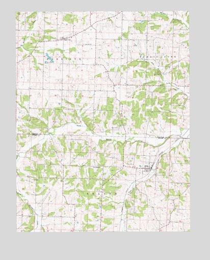
Olean, MO USGS Topographic Map
Click on map above to begin viewing in our Map Viewer.

This topographic map contains these locations and features:
Feature Name Type Latitude Longitude GNIS ID View Map
Allen CemeteryCemeteryN38.4150°W92.5010°713214View Map
Beard CreekStreamN38.4192°W92.6232°713828View Map
Bond Lake DamDamN38.4367°W92.5219°765135View Map
California Rural Fire Protection District High Point Fire StationBuildingN38.4841°W92.5915°2621182View Map
Colburn BranchStreamN38.4809°W92.6196°716077View Map
Enon School (historical)SchoolN38.4623°W92.5041°743622View Map
Goodmans (historical)LocaleN38.4261°W92.5099°744713View Map
Grant School (historical)SchoolN38.4548°W92.5602°743625View Map
Gray CemeteryCemeteryN38.4536°W92.5457°718761View Map
Green Ridge ChurchChurchN38.4120°W92.5652°729503View Map
Greenridge CemeteryCemeteryN38.4113°W92.5649°2702466View Map
High PointPopulated PlaceN38.4845°W92.5907°719534View Map
High Point CemeteryCemeteryN38.4817°W92.5760°719536View Map
High Point Elementary SchoolSchoolN38.4851°W92.5851°2571122View Map
Hite CemeteryCemeteryN38.4039°W92.5938°719637View Map
Lincoln School (historical)SchoolN38.4423°W92.5163°743629View Map
Manning School (historical)SchoolN38.4134°W92.5999°744511View Map
OleanPopulated PlaceN38.4109°W92.5294°729593View Map
Olean CemeteryCemeteryN38.4131°W92.5416°723800View Map
Olean Post OfficePost OfficeN38.4106°W92.5289°2783016View Map
Pleasant MountPopulated PlaceN38.3764°W92.5227°755629View Map
Prairie Hill School (historical)SchoolN38.4564°W92.6096°743638View Map
Rock Enon ChurchChurchN38.4642°W92.5205°725453View Map
Sand Hill School (historical)SchoolN38.4103°W92.5488°744513View Map
Sherman School (historical)SchoolN38.4948°W92.5355°743640View Map
Taylor School (historical)SchoolN38.3767°W92.6032°744512View Map
Tiff MineMineN38.4400°W92.5802°727652View Map
Town of OleanCivilN38.4104°W92.5300°2396832View Map
Township of HarrisonCivilN38.4787°W92.6045°767031View Map
Walker CemeteryCemeteryN38.4339°W92.5524°728261View Map

Note: Coordinates in the location and feature list above are referenced to NAD83 datum.


Copyright (C) 2008-2025 Ryan Niemi / Sunset Dynamics ... All Rights Reserved