TopoQuest Logo
Do you find TopoQuest useful?
Help keep TopoQuest running and adding new maps/features by donating!
Bitcoin:  19c7KJd3qBynnjoSw5npx9KScwjBe4ifkT
Litecoin:  LXs6TkuXGGXo1vDsWCkWVdjQX94eUKd6ui
Home View Maps Find Maps Find Places Resources & Links


Eugene, Missouri Topographic Map

USGS Map Title: Eugene, MO
USGS Map MRC: 38092C4
DRG (GeoTIFF) Download: o38092c4.tif


Neighboring USGS Topographic Map Quads:


  Olean, MO  
38092D5
 

  Enon, MO  
38092D4
 

  Brazito, MO  
38092D3
 

  Eldon, MO  
38092C5
 

  Eugene, MO  
38092C4
 

  Saint Elizabeth, MO  
38092C3
 

  Bagnell, MO  
38092B5
 

  Tuscumbia, MO  
38092B4
 

  Saint Anthony, MO  
38092B3


Map MRC Location:

N39°
W93°
N39°
W92°
H8 H7 H6 H5 H4 H3 H2 H1
G8 G7 G6 G5 G4 G3 G2 G1
F8 F7 F6 F5 F4 F3 F2 F1
E8 E7 E6 E5 E4 E3 E2 E1
D8 D7 D6 D5 D4 D3 D2 D1
C8 C7 C6 C5 C4 C3 C2 C1
B8 B7 B6 B5 B4 B3 B2 B1
A8 A7 A6 A5 A4 A3 A2 A1
N38°
W93°
N38°
W92°

Eugene, MO USGS 1:24K Topographic Map Preview:
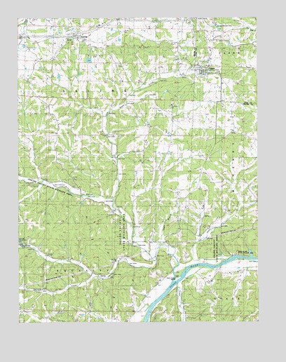
Eugene, MO USGS Topographic Map
Click on map above to begin viewing in our Map Viewer.

This topographic map contains these locations and features:
Feature Name Type Latitude Longitude GNIS ID View Map
Bittle DamDamN38.3567°W92.4619°763904View Map
Butzer Lake DamDamN38.2767°W92.3785°764776View Map
Central ChurchChurchN38.3086°W92.4710°729457View Map
Central Church (historical)ChurchN38.3314°W92.4569°744526View Map
Cole County Fire Protection District Station 5BuildingN38.3598°W92.3997°2620412View Map
Coon CreekStreamN38.2656°W92.4174°716251View Map
Coon Creek IslandIslandN38.2689°W92.4168°716261View Map
Cumpton BranchStreamN38.3081°W92.4877°716592View Map
Dry CreekStreamN38.2684°W92.4571°717093View Map
Eagle BranchStreamN38.2820°W92.4257°738442View Map
EttervillePopulated PlaceN38.3675°W92.4702°729480View Map
EugenePopulated PlaceN38.3528°W92.4038°717644View Map
Eugene Census Designated PlaceCensusN38.3542°W92.4034°2790921View Map
Eugene Elementary SchoolSchoolN38.3726°W92.3967°2571062View Map
Eugene High SchoolSchoolN38.3722°W92.3967°2571063View Map
Eugene Post OfficePost OfficeN38.3540°W92.4022°2782886View Map
Gageville CemeteryCemeteryN38.3161°W92.4332°718302View Map
Gageville School (historical)SchoolN38.3203°W92.4385°718303View Map
Gleenwood ChurchChurchN38.3286°W92.4563°729498View Map
Harbison SchoolSchoolN38.3206°W92.4919°719080View Map
Jack Buster CreekStreamN38.2989°W92.4505°754121View Map
Jim Henry CreekStreamN38.2753°W92.3927°720321View Map
Jim Henry School (historical)SchoolN38.2928°W92.3955°720322View Map
Kings Bluff State Wildlife AreaParkN38.2784°W92.3863°742973View Map
Little Saline CreekStreamN38.2770°W92.4288°721311View Map
Munson DamDamN38.3500°W92.4785°763915View Map
Pleasant Ball SchoolSchoolN38.3228°W92.3841°729608View Map
Rock House (historical)BuildingN38.3034°W92.4060°744527View Map
Rush Chapel (historical)ChurchN38.2948°W92.3902°729636View Map
Saline CreekStreamN38.2720°W92.4130°725953View Map
Saline Valley ChurchChurchN38.2753°W92.4496°729644View Map
Saline Valley State Wildlife AreaParkN38.2989°W92.4552°742972View Map
State of MissouriCivilN38.3676°W92.4774°1779791View Map
Thompson CemeteryCemeteryN38.2661°W92.4863°727598View Map
Township of Jim HenryCivilN38.2904°W92.3923°767019View Map
Tuscumbia Fire DepartmentBuildingN38.2551°W92.4976°2620358View Map
Waterloo School (historical)SchoolN38.3642°W92.3810°728408View Map
Wright SchoolSchoolN38.2773°W92.4421°729164View Map

Note: Coordinates in the location and feature list above are referenced to NAD83 datum.


Copyright (C) 2008-2025 Ryan Niemi / Sunset Dynamics ... All Rights Reserved