TopoQuest Logo
Do you find TopoQuest useful?
Help keep TopoQuest running and adding new maps/features by donating!
Bitcoin:  19c7KJd3qBynnjoSw5npx9KScwjBe4ifkT
Litecoin:  LXs6TkuXGGXo1vDsWCkWVdjQX94eUKd6ui
Home View Maps Find Maps Find Places Resources & Links


Onondaga Cave, Missouri Topographic Map

USGS Map Title: Onondaga Cave, MO
USGS Map MRC: 38091A2
DRG (GeoTIFF) Download: o38091a2.tif


Neighboring USGS Topographic Map Quads:


  Argo, MO  
38091B3
 

  Sullivan, MO  
38091B2
 

  Meramec State Park, MO  
38091B1
 

  Leasburg, MO  
38091A3
 

  Onondaga Cave, MO  
38091A2
 

  Anthonies Mill, MO  
38091A1
 

  Steelville, MO  
37091H3
 

  Huzzah, MO  
37091H2
 

  Berryman, MO  
37091H1


Map MRC Location:

N39°
W92°
N39°
W91°
H8 H7 H6 H5 H4 H3 H2 H1
G8 G7 G6 G5 G4 G3 G2 G1
F8 F7 F6 F5 F4 F3 F2 F1
E8 E7 E6 E5 E4 E3 E2 E1
D8 D7 D6 D5 D4 D3 D2 D1
C8 C7 C6 C5 C4 C3 C2 C1
B8 B7 B6 B5 B4 B3 B2 B1
A8 A7 A6 A5 A4 A3 A2 A1
N38°
W92°
N38°
W91°

Onondaga Cave, MO USGS 1:24K Topographic Map Preview:
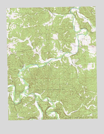
Onondaga Cave, MO USGS Topographic Map
Click on map above to begin viewing in our Map Viewer.

This topographic map contains these locations and features:
Feature Name Type Latitude Longitude GNIS ID View Map
Bass BranchStreamN38.0198°W91.1843°748701View Map
Baumstark LakeReservoirN38.0034°W91.1885°764416View Map
Baumstark Lake DamDamN38.0034°W91.1885°764415View Map
Bessen RiverStreamN38.0625°W91.1590°736505View Map
Bleeding Hill Copper MinesMineN38.0414°W91.1540°736504View Map
Bleeding Hill Iron BankMineN38.0314°W91.1585°736503View Map
Blue Springs CreekStreamN38.1212°W91.1607°748941View Map
Bobs CreekStreamN38.0687°W91.1738°748949View Map
Bouse CreekStreamN38.0664°W91.1418°736502View Map
Brandel LakeLakeN38.0759°W91.1736°748995View Map
Brazil CreekStreamN38.1225°W91.1496°749008View Map
Campbell BridgeBridgeN38.0814°W91.1499°755022View Map
Cathedral SpringSpringN38.0540°W91.2342°2749305View Map
Cedar Grove SchoolLocaleN38.0973°W91.1315°753349View Map
Courtois CreekStreamN38.0267°W91.2118°749499View Map
CrossroadsPopulated PlaceN38.0748°W91.2440°736507View Map
Crossroads ChurchChurchN38.0745°W91.2446°749539View Map
Davis FordLocaleN38.0584°W91.2238°736500View Map
Doss BranchStreamN38.0192°W91.1888°749686View Map
Fair View HillSummitN38.0020°W91.1540°736499View Map
Fairview ChurchChurchN38.0020°W91.1538°749888View Map
Forest Hill SchoolSchoolN38.1125°W91.2451°753345View Map
Fred Weber LakeReservoirN38.0834°W91.2168°763609View Map
Hardy CemeteryCemeteryN38.0812°W91.1474°750227View Map
Hardy FordLocaleN38.0812°W91.1499°736498View Map
Harman CreekStreamN38.0323°W91.2410°750230View Map
Harrison CemeteryCemeteryN38.0881°W91.1393°750242View Map
Harrison FordLocaleN38.0942°W91.1399°736506View Map
Harrison MillsPopulated PlaceN38.0803°W91.1465°736497View Map
HinchPopulated PlaceN38.0628°W91.1554°750337View Map
Hinch BranchStreamN38.0739°W91.1629°750338View Map
Hinch Copper MineMineN38.0353°W91.1449°736496View Map
Hinch School (historical)SchoolN38.0609°W91.1543°736495View Map
Hinchs Lead DiggingsMineN38.0353°W91.1404°736494View Map
Hobo BranchStreamN38.1156°W91.1818°736493View Map
Hobo Iron and Sulphur MinesMineN38.1003°W91.1921°736492View Map
Hog Trough BridgeBridgeN38.1200°W91.1601°736491View Map
Huzzah Conservation AreaParkN38.0369°W91.1939°750440View Map
Huzzah CreekStreamN38.0334°W91.2249°750439View Map
Iroquois ParkParkN38.0334°W91.2349°736509View Map
Isgreeg Lead MineMineN38.0464°W91.1518°736490View Map
Kelly BranchStreamN38.0595°W91.2207°736489View Map
Knox Number Two Iron MineMineN38.0739°W91.1426°736488View Map
Lea HillSummitN38.0373°W91.2093°736487View Map
Lockhart Lead MineMineN38.0248°W91.2274°736486View Map
Number 410 DamDamN38.0284°W91.1268°764864View Map
Onondaga Cave State ParkParkN38.0592°W91.2304°2749274View Map
Onondaga SpringSpringN38.0600°W91.2282°2749199View Map
Opossum HollowValleyN38.0639°W91.1979°751443View Map
Opossum Hollow DamDamN38.0834°W91.2168°763608View Map
Pentecostal ChurchChurchN38.0175°W91.2407°751541View Map
Pleasant Hill SchoolSchoolN38.0959°W91.1782°753350View Map
Pleasant Ridge ChurchChurchN38.1012°W91.1724°751667View Map
Ransom Lead DiggingsMineN38.0050°W91.1340°736485View Map
Rich Hill Lead DiggingsMineN38.0520°W91.1557°736501View Map
Rives Copper MineMineN38.0945°W91.1924°736484View Map
Rutledge Lead DiggingsMineN38.0867°W91.1426°736483View Map
ScotiaPopulated PlaceN38.0278°W91.2138°752061View Map
Scotia Number One Iron BankMineN38.0320°W91.1990°736482View Map
Scotia Number Two Iron BankMineN38.0603°W91.1482°736481View Map
Scotia School (historical)LocaleN38.0287°W91.2024°753348View Map
The NarrowsGapN38.0078°W91.1985°752521View Map
Township of LibertyCivilN38.0607°W91.1973°766544View Map
Valley SchoolSchoolN38.0781°W91.2196°753347View Map
VilanderPopulated PlaceN38.0964°W91.1315°752715View Map
Von Hoffman Lake (historical)LocaleN38.1178°W91.1865°753346View Map

Note: Coordinates in the location and feature list above are referenced to NAD83 datum.


Copyright (C) 2008-2024 Ryan Niemi / Sunset Dynamics ... All Rights Reserved