TopoQuest Logo
Do you find TopoQuest useful?
Help keep TopoQuest running and adding new maps/features by donating!
Bitcoin:  19c7KJd3qBynnjoSw5npx9KScwjBe4ifkT
Litecoin:  LXs6TkuXGGXo1vDsWCkWVdjQX94eUKd6ui
Home View Maps Find Maps Find Places Resources & Links


Ontario, Wisconsin Topographic Map

USGS Map Title: Ontario, WI
USGS Map MRC: 43090F5
DRG (GeoTIFF) Download: o43090f5.tif


Neighboring USGS Topographic Map Quads:


  Saint Marys, WI  
43090G6
 

  Wilton, WI  
43090G5
 

  Kendall West, WI  
43090G4
 

  Dell, WI  
43090F6
 

  Ontario, WI  
43090F5
 

  Trippville, WI  
43090F4
 

  La Farge, WI  
43090E6
 

  West Lima, WI  
43090E5
 

  Yuba, WI  
43090E4


Map MRC Location:

N44°
W91°
N44°
W90°
H8 H7 H6 H5 H4 H3 H2 H1
G8 G7 G6 G5 G4 G3 G2 G1
F8 F7 F6 F5 F4 F3 F2 F1
E8 E7 E6 E5 E4 E3 E2 E1
D8 D7 D6 D5 D4 D3 D2 D1
C8 C7 C6 C5 C4 C3 C2 C1
B8 B7 B6 B5 B4 B3 B2 B1
A8 A7 A6 A5 A4 A3 A2 A1
N43°
W91°
N43°
W90°

Ontario, WI USGS 1:24K Topographic Map Preview:
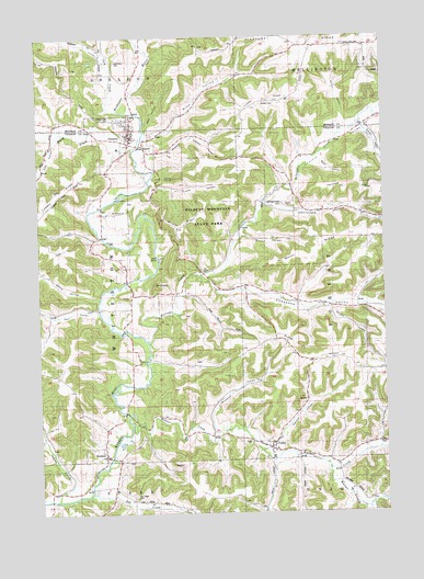
Ontario, WI USGS Topographic Map
Click on map above to begin viewing in our Map Viewer.

This topographic map contains these locations and features:
Feature Name Type Latitude Longitude GNIS ID View Map
Bear ValleyValleyN43.7166°W90.5222°1561399View Map
Bee HollowValleyN43.7257°W90.5862°1561490View Map
Billings CreekStreamN43.6702°W90.5860°1561791View Map
Billings Creek CemeteryCemeteryN43.7061°W90.5371°1561792View Map
Biscuit ValleyValleyN43.7115°W90.5338°1840856View Map
Biscuit ValleyValleyN43.6979°W90.5514°1561827View Map
Brey ValleyValleyN43.7237°W90.5860°1562181View Map
Brush CreekStreamN43.7205°W90.5899°1562303View Map
Burr RidgeRidgeN43.6625°W90.5043°1562453View Map
Calvin Day CemeteryCemeteryN43.7477°W90.5129°1562558View Map
Caucut ValleyValleyN43.6425°W90.5407°1562821View Map
Cheyenne ValleyValleyN43.6870°W90.5651°1562999View Map
Cholvin ValleyValleyN43.7069°W90.5426°1563046View Map
Cook CreekStreamN43.7302°W90.5974°1563338View Map
Cook ValleyValleyN43.7359°W90.5975°1563343View Map
Crouch ValleyValleyN43.7255°W90.5065°1563565View Map
Eastman School (historical)SchoolN43.6453°W90.5015°1840833View Map
Fairview RidgeRidgeN43.7111°W90.5090°1564820View Map
Flag RockPillarN43.7130°W90.5771°1565050View Map
Gordon CemeteryCemeteryN43.7325°W90.5426°1565675View Map
Hay ValleyValleyN43.6778°W90.6038°1566211View Map
Hay Valley CreekStreamN43.6772°W90.6029°2760696View Map
Hilltop Rest CemeteryCemeteryN43.7289°W90.5985°1834465View Map
Hoff ValleyValleyN43.7234°W90.6182°1566509View Map
Indian CreekStreamN43.6283°W90.6201°1566910View Map
Johnniecake School (historical)SchoolN43.7044°W90.5326°1840837View Map
Johnnycake HollowValleyN43.7060°W90.5409°1567202View Map
Jug CreekStreamN43.6303°W90.6074°1567307View Map
Jug Creek CemeteryCemeteryN43.6300°W90.5915°1834469View Map
Jug Creek School (historical)SchoolN43.6258°W90.5726°1840838View Map
Kickapoo Valley Reserve State Natural AreaParkN43.6636°W90.5918°2060498View Map
Lamb ValleyValleyN43.7114°W90.5843°1567814View Map
Lowers RidgeRidgeN43.7072°W90.6207°1568764View Map
Miller ValleyValleyN43.7271°W90.5139°1569521View Map
Moon RidgeRidgeN43.6955°W90.5221°1569697View Map
Mount PisgahSummitN43.6841°W90.5832°1571563View Map
Mount Pisgah ChurchChurchN43.6819°W90.5871°1569831View Map
Mount Pisgah Hemlock-Hardwoods State Natural AreaParkN43.6894°W90.5796°2060499View Map
Mount Pisgah School (historical)SchoolN43.6866°W90.5718°1840842View Map
Oden School (historical)SchoolN43.6675°W90.5921°1840845View Map
OntarioPopulated PlaceN43.7258°W90.5915°1570841View Map
Ontario Emergency Medical ServicesBuildingN43.7230°W90.5923°2698395View Map
Ontario Fire DepartmentBuildingN43.7230°W90.5923°2697992View Map
Ontario Police DepartmentBuildingN43.7239°W90.5914°2759939View Map
Pleasant RidgeRidgeN43.7475°W90.5537°1571627View Map
Red Brick School (historical)SchoolN43.7469°W90.5229°1846267View Map
Revels ValleyValleyN43.6787°W90.5201°1572224View Map
RocktonPopulated PlaceN43.6411°W90.6018°1572487View Map
Salem School (historical)SchoolN43.6675°W90.5332°1840849View Map
South Billings CreekStreamN43.6874°W90.5666°2760697View Map
South Jug CreekStreamN43.6261°W90.5907°1574460View Map
Town of WhitestownCivilN43.6815°W90.6120°1584431View Map
Tuttle RidgeRidgeN43.7336°W90.5435°1575754View Map
ValleyPopulated PlaceN43.6416°W90.5418°1576018View Map
Village of OntarioCivilN43.7222°W90.5941°1583864View Map
Walker ValleyValleyN43.7183°W90.5844°1576161View Map
Warner BranchStreamN43.6364°W90.5207°1576213View Map
Warner CreekStreamN43.6469°W90.5921°1576215View Map
Wesleyan ChurchChurchN43.7044°W90.5976°1834501View Map
White HollowValleyN43.6813°W90.6034°1576640View Map
Wildcat MountainSummitN43.6994°W90.5743°1576743View Map
Wildcat Mountain State ParkParkN43.7005°W90.5615°1576744View Map
Winchell ValleyValleyN43.6473°W90.5626°1576839View Map

Note: Coordinates in the location and feature list above are referenced to NAD83 datum.


Copyright (C) 2008-2024 Ryan Niemi / Sunset Dynamics ... All Rights Reserved