TopoQuest Logo
Do you find TopoQuest useful?
Help keep TopoQuest running and adding new maps/features by donating!
Bitcoin:  19c7KJd3qBynnjoSw5npx9KScwjBe4ifkT
Litecoin:  LXs6TkuXGGXo1vDsWCkWVdjQX94eUKd6ui
Home View Maps Find Maps Find Places Resources & Links


Oriskany Falls, New York Topographic Map

USGS Map Title: Oriskany Falls, NY
USGS Map MRC: 42075H4
DRG (GeoTIFF) Download: o42075h4.tif


Neighboring USGS Topographic Map Quads:


  Vernon, NY  
43075A5
 

  Clinton, NY  
43075A4
 

  Utica West, NY  
43075A3
 

  Munnsville, NY  
42075H5
 

  Oriskany Falls, NY  
42075H4
 

  Cassville, NY  
42075H3
 

  Hamilton, NY  
42075G5
 

  Hubbardsville, NY  
42075G4
 

  Brookfield, NY  
42075G3


Map MRC Location:

N43°
W76°
N43°
W75°
H8 H7 H6 H5 H4 H3 H2 H1
G8 G7 G6 G5 G4 G3 G2 G1
F8 F7 F6 F5 F4 F3 F2 F1
E8 E7 E6 E5 E4 E3 E2 E1
D8 D7 D6 D5 D4 D3 D2 D1
C8 C7 C6 C5 C4 C3 C2 C1
B8 B7 B6 B5 B4 B3 B2 B1
A8 A7 A6 A5 A4 A3 A2 A1
N42°
W76°
N42°
W75°

Oriskany Falls, NY USGS 1:24K Topographic Map Preview:
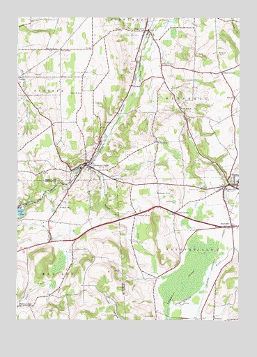
Oriskany Falls, NY USGS Topographic Map
Click on map above to begin viewing in our Map Viewer.

This topographic map contains these locations and features:
Feature Name Type Latitude Longitude GNIS ID View Map
Alcott GreenhousesLocaleN42.9208°W75.4286°2542341View Map
Barker Brook Golf ClubLocaleN42.9406°W75.4840°2615340View Map
Big CreekStreamN42.9967°W75.4160°943869View Map
BrothertownPopulated PlaceN42.9487°W75.4213°972268View Map
Buckley Mill CreekStreamN42.9370°W75.4566°945078View Map
C W Clark Memorial LibraryBuildingN42.9399°W75.4596°2617236View Map
Conger CornersPopulated PlaceN42.9195°W75.4110°947279View Map
DeansboroPopulated PlaceN42.9951°W75.4285°948145View Map
Deansboro Congregational United Church of ChristChurchN42.9938°W75.4292°2615836View Map
Deansboro Fire Department Barton Hose CompanyBuildingN42.9922°W75.4292°2734837View Map
First Baptist ChurchChurchN42.9308°W75.3772°2416943View Map
First Presbyterian ChurchChurchN42.9314°W75.3789°2416942View Map
Five CornersLocaleN42.9867°W75.4763°950198View Map
Forge HollowPopulated PlaceN42.9628°W75.4088°950439View Map
Gibbons CornersLocaleN42.9778°W75.3852°951060View Map
Grace Episcopal ChurchChurchN42.9308°W75.3767°2436587View Map
Grace Episcopal ChurchChurchN42.9314°W75.3772°2416946View Map
Grant HillSummitN42.9842°W75.3854°951513View Map
HanoverPopulated PlaceN42.9670°W75.3777°952173View Map
Harding Nursing HomeBuildingN42.9328°W75.3849°2614663View Map
Loomis HillSummitN42.8767°W75.4293°955966View Map
Lyons PondReservoirN42.9199°W75.4986°970325View Map
Madison CenterPopulated PlaceN42.8806°W75.4982°956254View Map
O'Toole's CemeteryCemeteryN42.9869°W75.4824°959092View Map
Oriskany FallsPopulated PlaceN42.9392°W75.4610°959483View Map
Oriskany Falls Fire DepartmentBuildingN42.9334°W75.4664°2718245View Map
Oriskany Falls QuarryMineN42.9522°W75.4578°2712456View Map
Oriskany Falls Wastewater Treatment PlantLocaleN42.9391°W75.4587°2617741View Map
Pleasant ValleyPopulated PlaceN42.9187°W75.4330°960721View Map
Saint Bernard's CemeteryCemeteryN42.9290°W75.3966°963377View Map
Saint Josephs CemeteryCemeteryN42.9213°W75.4763°963729View Map
Sanger HillSummitN42.9276°W75.4129°964456View Map
SangerfieldPopulated PlaceN42.9140°W75.3791°964457View Map
Sangerfield Post OfficePost OfficeN42.9162°W75.3788°2618104View Map
School Number 10 (historical)SchoolN42.9687°W75.4643°974956View Map
Signal Mobile Home ParkPopulated PlaceN42.9697°W75.4364°2485840View Map
Small CornersPopulated PlaceN42.9803°W75.4191°965445View Map
Stockwell FarmsLocaleN42.8831°W75.3894°2542346View Map
Thistle CemeteryCemeteryN42.9775°W75.4625°967386View Map
Town of MarshallCivilN42.9671°W75.3862°979201View Map
Town of SangerfieldCivilN42.9004°W75.3765°979458View Map
Village of Oriskany FallsCivilN42.9380°W75.4636°2391040View Map
Village of WatervilleCivilN42.9306°W75.3802°2391199View Map
WatervillePopulated PlaceN42.9312°W75.3799°968917View Map
Waterville Baptist ChurchChurchN42.9317°W75.3775°2436589View Map
Waterville Central SchoolSchoolN42.9325°W75.3758°2416945View Map
Waterville High SchoolSchoolN42.9239°W75.3928°2436578View Map
Waterville Municipal BuildingBuildingN42.9297°W75.3772°2416944View Map
Waterville Post OfficePost OfficeN42.9305°W75.3800°2780798View Map
Waterville Public LibraryBuildingN42.9301°W75.3767°2617452View Map
Waterville Village CemeteryCemeteryN42.9336°W75.3792°2568189View Map
Waterville Village Sewage Treatment PlantLocaleN42.9406°W75.3919°2617773View Map
Waterville Volunteer Fire Department Engine HouseBuildingN42.9308°W75.3766°2718594View Map

Note: Coordinates in the location and feature list above are referenced to NAD83 datum.


Copyright (C) 2008-2025 Ryan Niemi / Sunset Dynamics ... All Rights Reserved