TopoQuest Logo
Do you find TopoQuest useful?
Help keep TopoQuest running and adding new maps/features by donating!
Bitcoin:  19c7KJd3qBynnjoSw5npx9KScwjBe4ifkT
Litecoin:  LXs6TkuXGGXo1vDsWCkWVdjQX94eUKd6ui
Home View Maps Find Maps Find Places Resources & Links


Palermo, California Topographic Map

USGS Map Title: Palermo, CA
USGS Map MRC: 39121D5
DRG (GeoTIFF) Download: o39121d5.tif


Neighboring USGS Topographic Map Quads:


  Shippee, CA  
39121E6
 

  Oroville, CA  
39121E5
 

  Oroville Dam, CA  
39121E4
 

  Biggs, CA  
39121D6
 

  Palermo, CA  
39121D5
 

  Bangor, CA  
39121D4
 

  Gridley, CA  
39121C6
 

  Honcut, CA  
39121C5
 

  Loma Rica, CA  
39121C4


Map MRC Location:

N40°
W122°
N40°
W121°
H8 H7 H6 H5 H4 H3 H2 H1
G8 G7 G6 G5 G4 G3 G2 G1
F8 F7 F6 F5 F4 F3 F2 F1
E8 E7 E6 E5 E4 E3 E2 E1
D8 D7 D6 D5 D4 D3 D2 D1
C8 C7 C6 C5 C4 C3 C2 C1
B8 B7 B6 B5 B4 B3 B2 B1
A8 A7 A6 A5 A4 A3 A2 A1
N39°
W122°
N39°
W121°

Palermo, CA USGS 1:24K Topographic Map Preview:
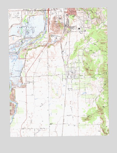
Palermo, CA USGS Topographic Map
Click on map above to begin viewing in our Map Viewer.

This topographic map contains these locations and features:
Feature Name Type Latitude Longitude GNIS ID View Map
Apostolic ChurchChurchN39.4938°W121.5455°1723911View Map
Burbank SchoolSchoolN39.4977°W121.5494°220173View Map
Burts Ferry (historical)CrossingN39.3891°W121.6247°1723922View Map
Butte County Fire Department Station 72BuildingN39.4356°W121.5456°2622330View Map
Center DitchCanalN39.4516°W121.5316°220817View Map
Church of God in ChristChurchN39.4991°W121.5416°1723930View Map
City of OrovilleCivilN39.4999°W121.5633°2411337View Map
Clay Pit State Vehicular Recreation AreaParkN39.4808°W121.6118°2570553View Map
El Medio Fire DepartmentBuildingN39.4969°W121.5482°2622258View Map
Feather River Adventist SchoolSchoolN39.3831°W121.6104°223425View Map
First Christian ChurchChurchN39.4985°W121.5497°1723949View Map
First Responder Emergency Medical Services Station 21BuildingN39.4988°W121.5865°2662244View Map
Garden Ranch (historical)LocaleN39.4838°W121.5052°1723955View Map
Grace Baptist ChurchChurchN39.4996°W121.5486°1723956View Map
Helen M Wilcox Elementary SchoolSchoolN39.4754°W121.5358°237742View Map
Henderson DitchCanalN39.4693°W121.5105°225162View Map
Holy Church of GodChurchN39.4988°W121.5433°1723965View Map
Las Plumas High SchoolSchoolN39.4804°W121.5375°226896View Map
Lava Beds (historical)Populated PlaceN39.4741°W121.5702°1723973View Map
Lone Tree SchoolSchoolN39.3868°W121.5761°227532View Map
Memorial Park CemeteryCemeteryN39.4777°W121.5516°228490View Map
Mooretown RancheriaCivilN39.4693°W121.5189°2419023View Map
Natomas 100 PitMineN39.4647°W121.5908°2681142View Map
North DitchCanalN39.4571°W121.5194°229631View Map
Oak GrovePopulated PlaceN39.4271°W121.6052°1659267View Map
Oakdale Heights Elementary SchoolSchoolN39.4802°W121.5461°229883View Map
Oroville Army Air Field (historical)MilitaryN39.4889°W121.6194°1988669View Map
Oroville CemeteryCemeteryN39.4949°W121.5716°230108View Map
Oroville Municipal AirportAirportN39.4900°W121.6190°1653787View Map
Oroville Wildlife AreaParkN39.4599°W121.6161°234416View Map
Pacific Heights PitMineN39.4658°W121.5897°2725187View Map
PalermoPopulated PlaceN39.4354°W121.5380°277571View Map
Palermo Census Designated PlaceCensusN39.4313°W121.5225°2409019View Map
Palermo DivisionCivilN39.3935°W121.5073°1935238View Map
Palermo ParkParkN39.4327°W121.5441°1723989View Map
Palermo Post OfficePost OfficeN39.4354°W121.5518°2769457View Map
Palermo SchoolSchoolN39.4368°W121.5466°1723990View Map
Palermo SubstationLocaleN39.4546°W121.5177°1654363View Map
Pentecostal Church of GodChurchN39.4941°W121.5433°1723993View Map
Siller Bros Inc Airport (historical)AirportN39.4579°W121.5835°1653789View Map
South DitchCanalN39.4399°W121.5022°234954View Map
South OrovillePopulated PlaceN39.4966°W121.5522°1659826View Map
South Oroville Census Designated PlaceCensusN39.4767°W121.5439°2408768View Map
The Church of Jesus Christ of Latter Day SaintsChurchN39.4763°W121.5364°1723933View Map
Thermalito Census Designated PlaceCensusN39.4823°W121.5982°2410077View Map
Union School (historical)SchoolN39.4332°W121.6050°1670425View Map
Vista RoblesPopulated PlaceN39.4207°W121.5525°1660108View Map
Western CanalCanalN39.4716°W121.5955°237540View Map
Wyandotte SubstationLocaleN39.4918°W121.5419°1654528View Map

Note: Coordinates in the location and feature list above are referenced to NAD83 datum.


Copyright (C) 2008-2024 Ryan Niemi / Sunset Dynamics ... All Rights Reserved