TopoQuest Logo
Do you find TopoQuest useful?
Help keep TopoQuest running and adding new maps/features by donating!
Bitcoin:  19c7KJd3qBynnjoSw5npx9KScwjBe4ifkT
Litecoin:  LXs6TkuXGGXo1vDsWCkWVdjQX94eUKd6ui
Home View Maps Find Maps Find Places Resources & Links


Rosebud, Missouri Topographic Map

USGS Map Title: Rosebud, MO
USGS Map MRC: 38091D4
DRG (GeoTIFF) Download: o38091d4.tif


Neighboring USGS Topographic Map Quads:


  Pershing, MO  
38091E5
 

  Swiss, MO  
38091E4
 

  Dissen, MO  
38091E3
 

  Goerlisch Ridge, MO  
38091D5
 

  Rosebud, MO  
38091D4
 

  Gerald, MO  
38091D3
 

  Owensville West, MO  
38091C5
 

  Owensville East, MO  
38091C4
 

  Strain, MO  
38091C3


Map MRC Location:

N39°
W92°
N39°
W91°
H8 H7 H6 H5 H4 H3 H2 H1
G8 G7 G6 G5 G4 G3 G2 G1
F8 F7 F6 F5 F4 F3 F2 F1
E8 E7 E6 E5 E4 E3 E2 E1
D8 D7 D6 D5 D4 D3 D2 D1
C8 C7 C6 C5 C4 C3 C2 C1
B8 B7 B6 B5 B4 B3 B2 B1
A8 A7 A6 A5 A4 A3 A2 A1
N38°
W92°
N38°
W91°

Rosebud, MO USGS 1:24K Topographic Map Preview:
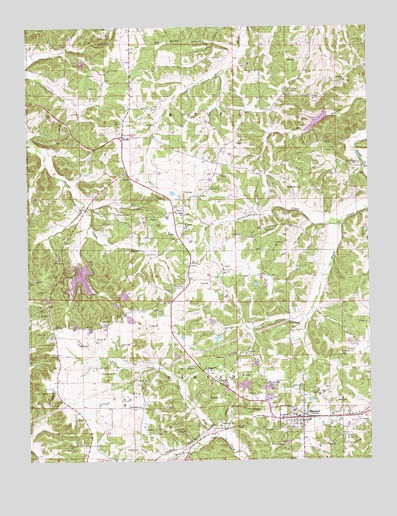
Rosebud, MO USGS Topographic Map
Click on map above to begin viewing in our Map Viewer.

This topographic map contains these locations and features:
Feature Name Type Latitude Longitude GNIS ID View Map
Ahmad Lake DamDamN38.4517°W91.4718°765375View Map
Becker Lake DamDamN38.3884°W91.4818°765369View Map
Beemont ChurchChurchN38.4845°W91.3832°729428View Map
Big Hollow BranchStreamN38.4934°W91.4224°714181View Map
Boston Lake DamDamN38.3984°W91.3768°764597View Map
Brandt Lake DamDamN38.3917°W91.3985°765371View Map
City of RosebudCivilN38.3851°W91.4024°2396431View Map
Daizy Valley Lake DamDamN38.4750°W91.3902°764595View Map
Daizy Vally ReservoirReservoirN38.4726°W91.3939°764596View Map
DrakePopulated PlaceN38.4684°W91.4646°717043View Map
Drake School (historical)SchoolN38.4887°W91.4496°744386View Map
Georgetown CemeteryCemeteryN38.4609°W91.3788°718404View Map
Gerald - Rosebud Fire Protection District Station 3BuildingN38.3853°W91.4041°2621346View Map
Immanual Evangelical Lutheran CemeteryCemeteryN38.3872°W91.4065°720083View Map
Immanuel CemeteryCemeteryN38.4463°W91.4678°720084View Map
Jackson Lake DamDamN38.4767°W91.4352°765374View Map
Kiehl School (historical)SchoolN38.4500°W91.4677°744388View Map
Lake NorthwoodReservoirN38.4275°W91.4806°765060View Map
Lake Northwoods DamDamN38.4317°W91.4818°763733View Map
Lake Northwoods West DamDamN38.4317°W91.4818°765059View Map
Langejammer CreekStreamN38.4434°W91.3846°720806View Map
Langenberg Lake DamDamN38.3984°W91.4202°765144View Map
Laury Lake DamDamN38.4250°W91.4168°765372View Map
Limberg Lake DamDamN38.4050°W91.4452°765370View Map
Lone Grove School (historical)SchoolN38.4909°W91.3957°744387View Map
Long BranchStreamN38.3750°W91.4515°721506View Map
Matthews CemeteryCemeteryN38.3948°W91.4907°721981View Map
New Salem CemeteryCemeteryN38.4005°W91.4739°723299View Map
New Salem ChurchChurchN38.3906°W91.4643°723308View Map
Palestine (historical)LocaleN38.3945°W91.4779°744385View Map
Pleasant Hill School (historical)SchoolN38.4420°W91.3927°744391View Map
Presbyterian Church (historical)ChurchN38.4464°W91.4679°744389View Map
RosebudPopulated PlaceN38.3873°W91.4010°729632View Map
Rosebud Post OfficePost OfficeN38.3873°W91.4099°2759148View Map
Saint James United Church of ChristChurchN38.4420°W91.4429°729640View Map
Saint James United Church of Christ CemeteryCemeteryN38.4420°W91.4419°2728377View Map
Saint Johns ChurchChurchN38.4456°W91.4429°729641View Map
Saint Johns SchoolSchoolN38.4453°W91.4429°744390View Map
Schroeder CemeteryCemeteryN38.4538°W91.4047°726122View Map
Sunswept Lake DamDamN38.4250°W91.4135°765373View Map
WiffenbergPopulated PlaceN38.4603°W91.4315°755628View Map
Wiseman School (historical)SchoolN38.3973°W91.4540°744392View Map
Zoar CemeteryCemeteryN38.4750°W91.4907°729260View Map
Zoar ChurchChurchN38.4728°W91.4649°729698View Map

Note: Coordinates in the location and feature list above are referenced to NAD83 datum.


Copyright (C) 2008-2025 Ryan Niemi / Sunset Dynamics ... All Rights Reserved