TopoQuest Logo
Do you find TopoQuest useful?
Help keep TopoQuest running and adding new maps/features by donating!
Bitcoin:  19c7KJd3qBynnjoSw5npx9KScwjBe4ifkT
Litecoin:  LXs6TkuXGGXo1vDsWCkWVdjQX94eUKd6ui
Home View Maps Find Maps Find Places Resources & Links


Oxford, West Virginia Topographic Map

USGS Map Title: Oxford, WV
USGS Map MRC: 39080B7
DRG (GeoTIFF) Download: o39080b7.tif


Neighboring USGS Topographic Map Quads:


  Pennsboro, WV  
39080C8
 

  West Union, WV  
39080C7
 

  Smithburg, WV  
39080C6
 

  Pullman, WV  
39080B8
 

  Oxford, WV  
39080B7
 

  New Milton, WV  
39080B6
 

  Burnt House, WV  
39080A8
 

  Auburn, WV  
39080A7
 

  Vadis, WV  
39080A6


Map MRC Location:

N40°
W81°
N40°
W80°
H8 H7 H6 H5 H4 H3 H2 H1
G8 G7 G6 G5 G4 G3 G2 G1
F8 F7 F6 F5 F4 F3 F2 F1
E8 E7 E6 E5 E4 E3 E2 E1
D8 D7 D6 D5 D4 D3 D2 D1
C8 C7 C6 C5 C4 C3 C2 C1
B8 B7 B6 B5 B4 B3 B2 B1
A8 A7 A6 A5 A4 A3 A2 A1
N39°
W81°
N39°
W80°

Oxford, WV USGS 1:24K Topographic Map Preview:
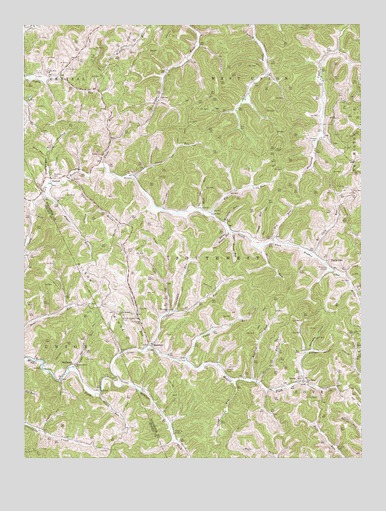
Oxford, WV USGS Topographic Map
Click on map above to begin viewing in our Map Viewer.

This topographic map contains these locations and features:
Feature Name Type Latitude Longitude GNIS ID View Map
Big RunStreamN39.1951°W80.8057°1535930View Map
Brush RunStreamN39.1440°W80.8468°1536474View Map
Cabin Run ChurchChurchN39.2362°W80.8665°1536841View Map
Cain RunStreamN39.1840°W80.7687°1536850View Map
Camp RunStreamN39.1509°W80.8565°1536942View Map
Camp RunStreamN39.1531°W80.8151°1536943View Map
Camp RunStreamN39.1879°W80.7912°1536944View Map
Camp Run School (historical)SchoolN39.1606°W80.8101°1689455View Map
Chapman RunStreamN39.1673°W80.8193°1537206View Map
Clevenger HollowValleyN39.2056°W80.8659°1537403View Map
Dry RunStreamN39.1870°W80.7826°1538375View Map
Freds RunStreamN39.2090°W80.8454°1539242View Map
Gray HollowValleyN39.2120°W80.8671°1539653View Map
GrovePopulated PlaceN39.1470°W80.7718°1554618View Map
Grove CemeteryCemeteryN39.1479°W80.7709°1689498View Map
Harmony School (historical)SchoolN39.1676°W80.8195°1689492View Map
Harmony United Methodist ChurchChurchN39.1676°W80.8212°1539980View Map
Hart CemeteryCemeteryN39.1851°W80.8370°1540021View Map
Hickory RunStreamN39.1920°W80.8007°1540222View Map
HolbrookPopulated PlaceN39.1523°W80.8559°1540380View Map
Holbrook BridgeBridgeN39.1446°W80.8463°2647474View Map
Holt RunStreamN39.1965°W80.8098°1540412View Map
Jims RunStreamN39.1670°W80.8220°1540913View Map
Leason CemeteryCemeteryN39.1506°W80.8004°1541583View Map
Leggett School (historical)SchoolN39.1843°W80.8454°1689515View Map
Long RunStreamN39.1473°W80.7973°1542406View Map
Lower RunStreamN39.1570°W80.8293°1542567View Map
Lower Run School (historical)SchoolN39.1568°W80.8320°1689522View Map
Lower Wizard RunStreamN39.1909°W80.7993°1542590View Map
Maxwell CemeteryCemeteryN39.2162°W80.7682°1542886View Map
Michaels CemeteryCemeteryN39.2065°W80.8643°1543153View Map
Mudlick RunStreamN39.1470°W80.7907°1543965View Map
Nutter CemeteryCemeteryN39.2131°W80.8465°1544257View Map
OxfordPopulated PlaceN39.2056°W80.8648°1555288View Map
Oxford United Methodist ChurchChurchN39.2056°W80.8646°1689550View Map
Painter RunStreamN39.1862°W80.7887°1544527View Map
Pine Grove ChurchChurchN39.1470°W80.7709°1544885View Map
Plaugher HollowValleyN39.1554°W80.7701°1544976View Map
Porto RicoPopulated PlaceN39.1820°W80.7629°1555395View Map
Sheep RunStreamN39.2062°W80.8343°1546653View Map
Short RunStreamN39.1465°W80.7879°1546734View Map
South Branch ChurchChurchN39.1665°W80.8407°1547064View Map
South Branch East CemeteryCemeteryN39.1659°W80.8382°1547065View Map
South Fork Baptist ChurchChurchN39.1993°W80.8621°1689592View Map
South Fork CemeteryCemeteryN39.2001°W80.8615°1689593View Map
Straight ForkStreamN39.1462°W80.8384°1547566View Map
Sugar RunStreamN39.2006°W80.8676°1547646View Map
SummersPopulated PlaceN39.1576°W80.8287°1549945View Map
Taylor DrainStreamN39.2051°W80.8579°1547933View Map
Trap RunStreamN39.1759°W80.8223°1548259View Map
Upper Arnold Creek School (historical)SchoolN39.2365°W80.8207°1689606View Map
Upper Cabin Run School (historical)SchoolN39.2354°W80.8609°1689610View Map
Upper Otterslide School (historical)SchoolN39.1481°W80.8607°1689109View Map
Upper Oxford School (historical)SchoolN39.2065°W80.8648°1689616View Map
Upper RunStreamN39.1570°W80.8279°1548548View Map
Upper Wizard RunStreamN39.1901°W80.7976°1548573View Map
Walnut Grove ChurchChurchN39.1518°W80.8562°1548764View Map
Williams HollowValleyN39.1565°W80.7684°1549178View Map
Wilson RidgeRidgeN39.1770°W80.8443°1549227View Map

Note: Coordinates in the location and feature list above are referenced to NAD83 datum.


Copyright (C) 2008-2024 Ryan Niemi / Sunset Dynamics ... All Rights Reserved