TopoQuest Logo
Do you find TopoQuest useful?
Help keep TopoQuest running and adding new maps/features by donating!
Bitcoin:  19c7KJd3qBynnjoSw5npx9KScwjBe4ifkT
Litecoin:  LXs6TkuXGGXo1vDsWCkWVdjQX94eUKd6ui
Home View Maps Find Maps Find Places Resources & Links


P A Mountain, New Mexico Topographic Map

USGS Map Title: P A Mountain, NM
USGS Map MRC: 32107G6
DRG (GeoTIFF) Download: o32107g6.tif


Neighboring USGS Topographic Map Quads:


  Hillsboro Peak, NM  
32107H7
 

  Kingston, NM  
32107H6
 

  Hillsboro, NM  
32107H5
 

  Maverick Mountain, NM  
32107G7
 

  P A Mountain, NM  
32107G6
 

  McClede Mountain, NM  
32107G5
 

  Dwyer, NM  
32107F7
 

  Whiterock Mountain, NM  
32107F6
 

  Lake Valley, NM  
32107F5


Map MRC Location:

N33°
W108°
N33°
W107°
H8 H7 H6 H5 H4 H3 H2 H1
G8 G7 G6 G5 G4 G3 G2 G1
F8 F7 F6 F5 F4 F3 F2 F1
E8 E7 E6 E5 E4 E3 E2 E1
D8 D7 D6 D5 D4 D3 D2 D1
C8 C7 C6 C5 C4 C3 C2 C1
B8 B7 B6 B5 B4 B3 B2 B1
A8 A7 A6 A5 A4 A3 A2 A1
N32°
W108°
N32°
W107°

P A Mountain, NM USGS 1:24K Topographic Map Preview:
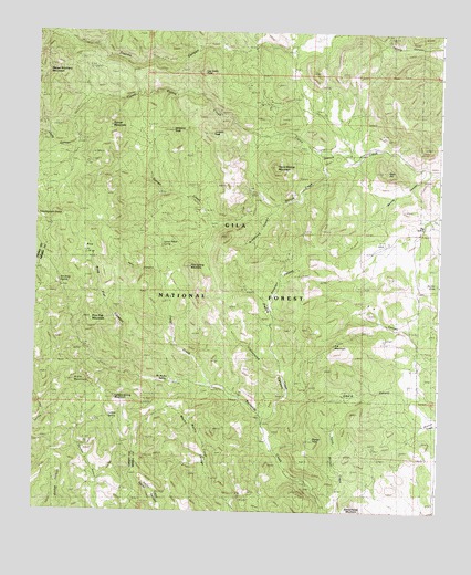
P A Mountain, NM USGS Topographic Map
Click on map above to begin viewing in our Map Viewer.

This topographic map contains these locations and features:
Feature Name Type Latitude Longitude GNIS ID View Map
Ant TankReservoirN32.8061°W107.6661°936703View Map
Armstrong CanyonValleyN32.8301°W107.6750°903278View Map
Beardog MineMineN32.8481°W107.7475°915468View Map
Berrenda SpringSpringN32.8101°W107.7434°2038364View Map
Big Japanese MineMineN32.8620°W107.7481°936851View Map
Big SpringSpringN32.8248°W107.6306°2038368View Map
Black MountainSummitN32.7834°W107.7356°903876View Map
Blue Bell Number TwoMineN32.7570°W107.6431°917093View Map
Boone CanyonValleyN32.8390°W107.6278°904008View Map
Casey CanyonValleyN32.8454°W107.7448°2038793View Map
Cottonwood CreekStreamN32.7734°W107.6786°905418View Map
Deer HillSummitN32.8390°W107.6434°905694View Map
Hells CanyonValleyN32.8123°W107.7106°906910View Map
Hornet GroupMineN32.8581°W107.6789°915452View Map
J P Nunn RanchLocaleN32.8401°W107.6536°907275View Map
Jalarosa TankReservoirN32.7819°W107.6582°936700View Map
Japanese MineMineN32.8584°W107.7489°936852View Map
Jayhawk GroupMineN32.8317°W107.6706°915576View Map
Juniper PeakSummitN32.8487°W107.6961°907489View Map
Larkins SpringSpringN32.7745°W107.7273°2038535View Map
Larkins Spring MountainSummitN32.7795°W107.7250°907854View Map
Latham Iron MineMineN32.7959°W107.6784°915456View Map
Lathum TankReservoirN32.7801°W107.6508°936701View Map
Lockwood WellWellN32.8034°W107.6784°936697View Map
Log CabinMineN32.8612°W107.7339°915574View Map
Log Cabin PeakSummitN32.8645°W107.6989°908115View Map
LookoutMineN32.8723°W107.7353°915460View Map
Mackey RanchLocaleN32.8273°W107.6273°908333View Map
McMullen SpringSpringN32.7840°W107.7098°2038563View Map
Mimbres MountainsRangeN32.8431°W107.7328°908774View Map
P A MountainSummitN32.7940°W107.6573°909415View Map
Pa Tank Number OneReservoirN32.7922°W107.6493°936699View Map
Pa Tank Number TwoReservoirN32.7895°W107.6463°936698View Map
Patton CreekStreamN32.7837°W107.6956°909512View Map
Pierce CanyonValleyN32.7731°W107.6792°909631View Map
Pine FlatFlatN32.8184°W107.7334°936706View Map
Pine Flat CanyonValleyN32.7848°W107.7173°909664View Map
Pine Flat MountainSummitN32.8006°W107.7328°909665View Map
Pine Spring MountainSummitN32.8142°W107.7023°909683View Map
Schoolhouse MountainSummitN32.7523°W107.6514°910877View Map
Signal PeakSummitN32.7695°W107.6639°911050View Map
Silver TailMineN32.8140°W107.6689°914586View Map
Silver Tail TankReservoirN32.8195°W107.6641°936695View Map
Silver TopMineN32.8562°W107.6750°917105View Map
Silvertail CanyonValleyN32.8042°W107.6767°911080View Map
Silvertail MineMineN32.8131°W107.6686°936696View Map
Silvertail MineMineN32.8131°W107.6684°911081View Map
Standard Metal MineMineN32.8617°W107.7178°914589View Map
Stoner CreekStreamN32.8417°W107.6539°911437View Map
Stoner MountainSummitN32.8506°W107.7270°911438View Map
Stoner Ridge SpringSpringN32.8198°W107.7117°2038702View Map
Thompson ConeSummitN32.8273°W107.7498°911662View Map
Tierra Blanca MountainSummitN32.8401°W107.6756°911702View Map
Toggery MineMineN32.8442°W107.6686°917100View Map
Uncle Lewis WellWellN32.8023°W107.6789°936694View Map
Upper Macho WindmillLocaleN32.7584°W107.6953°936702View Map
Upper Trap CorralLocaleN32.8345°W107.7459°936705View Map
White TankReservoirN32.7522°W107.7045°899287View Map
Williams PeakSummitN32.8492°W107.7089°2038789View Map

Note: Coordinates in the location and feature list above are referenced to NAD83 datum.


Copyright (C) 2008-2025 Ryan Niemi / Sunset Dynamics ... All Rights Reserved