TopoQuest Logo
Do you find TopoQuest useful?
Help keep TopoQuest running and adding new maps/features by donating!
Bitcoin:  19c7KJd3qBynnjoSw5npx9KScwjBe4ifkT
Litecoin:  LXs6TkuXGGXo1vDsWCkWVdjQX94eUKd6ui
Home View Maps Find Maps Find Places Resources & Links


Kingston, New Mexico Topographic Map

USGS Map Title: Kingston, NM
USGS Map MRC: 32107H6
DRG (GeoTIFF) Download: o32107h6.tif


Neighboring USGS Topographic Map Quads:


  Victorio Park, NM  
33107A7
 

  Apache Peak, NM  
33107A6
 

  Bell Mountain, NM  
33107A5
 

  Hillsboro Peak, NM  
32107H7
 

  Kingston, NM  
32107H6
 

  Hillsboro, NM  
32107H5
 

  Maverick Mountain, NM  
32107G7
 

  P A Mountain, NM  
32107G6
 

  McClede Mountain, NM  
32107G5


Map MRC Location:

N33°
W108°
N33°
W107°
H8 H7 H6 H5 H4 H3 H2 H1
G8 G7 G6 G5 G4 G3 G2 G1
F8 F7 F6 F5 F4 F3 F2 F1
E8 E7 E6 E5 E4 E3 E2 E1
D8 D7 D6 D5 D4 D3 D2 D1
C8 C7 C6 C5 C4 C3 C2 C1
B8 B7 B6 B5 B4 B3 B2 B1
A8 A7 A6 A5 A4 A3 A2 A1
N32°
W108°
N32°
W107°

Kingston, NM USGS 1:24K Topographic Map Preview:
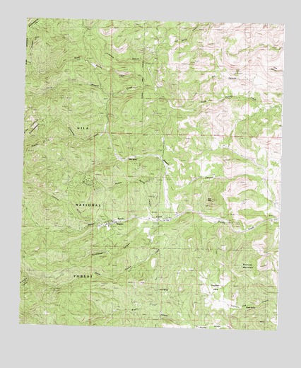
Kingston, NM USGS Topographic Map
Click on map above to begin viewing in our Map Viewer.

This topographic map contains these locations and features:
Feature Name Type Latitude Longitude GNIS ID View Map
Andy Johnson and Brush Heap MineMineN32.9192°W107.7245°915446View Map
Andy Johnson MineMineN32.9156°W107.7228°939621View Map
Barite Hill Number 1MineN32.9992°W107.7164°915447View Map
Basin and Cox RanchLocaleN32.9651°W107.6348°936719View Map
Basin TankReservoirN32.8979°W107.6584°936716View Map
Black Colt Claim - North KingstonMineN32.9370°W107.7214°940143View Map
Black Colt MineMineN32.9348°W107.7200°939620View Map
Black Magic MineMineN32.9001°W107.7242°939633View Map
Black Sheep Group MineMineN32.9334°W107.7298°915432View Map
Black Sheep-North Kingston D MineMineN32.9370°W107.7214°940144View Map
Blackeyed Susan MineMineN32.9156°W107.7228°939421View Map
Blackie Number 1 MineMineN32.9334°W107.7298°939618View Map
Blackie Number One MineMineN32.9370°W107.7214°940152View Map
Bloodgood A and B GroupMineN32.9131°W107.7025°917975View Map
Bloodgood MineMineN32.9167°W107.7006°939616View Map
Boundary TankReservoirN32.9605°W107.6975°936720View Map
Brush Heap MineMineN32.9156°W107.7228°914599View Map
Brushy CanyonValleyN32.8765°W107.6645°904107View Map
Brushy TankReservoirN32.8815°W107.6819°936714View Map
Calamity Jane MineMineN32.9156°W107.7228°939424View Map
Caledonia MineMineN32.9348°W107.7200°939984View Map
Carbonate CreekStreamN32.9687°W107.7081°904772View Map
Climax MineMineN32.9348°W107.7200°939427View Map
Comstock ClaimMineN32.9370°W107.7214°940153View Map
Comstock MineMineN32.9348°W107.7200°939428View Map
Cruise ShaftMineN32.9301°W107.7139°917185View Map
Curleys TankReservoirN32.8892°W107.6573°936709View Map
Dove MineMineN32.9334°W107.7131°939614View Map
Drummond CanyonValleyN32.8940°W107.7417°936590View Map
Dumm CanyonValleyN32.9740°W107.6859°905900View Map
Enterprise MineMineN32.9079°W107.7267°915291View Map
Fabian MIneMineN32.9617°W107.7111°915292View Map
General Jackson MineMineN32.9348°W107.7200°939557View Map
Gray EagleMineN32.8945°W107.7445°915450View Map
Gray Eagle MineMineN32.8945°W107.7442°906729View Map
Gypsy IV GroupMineN32.9392°W107.6936°915451View Map
Gypsy MineMineN32.9348°W107.7200°939622View Map
Hillsboro Volunteer Fire Station 2BuildingN32.9169°W107.7093°2658137View Map
Illinois MineMineN32.9156°W107.7228°939623View Map
Iron King MineMineN32.9348°W107.7200°939624View Map
Iron King MineMineN32.9334°W107.7298°939995View Map
Kangaroo MineMineN32.9348°W107.7200°939642View Map
KingstonPopulated PlaceN32.9170°W107.7061°907558View Map
Kingston CampgroundLocaleN32.9184°W107.7006°936717View Map
Kingston Census Designated PlaceCensusN32.9173°W107.7096°2584118View Map
Kingston Post Office (historical)Post OfficeN32.9170°W107.7061°938411View Map
Kingston Ranger StationLocaleN32.9162°W107.6861°907560View Map
Ladron GulchValleyN32.9181°W107.7098°907739View Map
Lady Franklin MineMineN32.9348°W107.7200°939625View Map
Lost TankReservoirN32.8764°W107.6412°936712View Map
Matchless MineMineN32.9348°W107.7200°939626View Map
Middle Percha CreekStreamN32.9201°W107.6620°908708View Map
Mineral CreekStreamN32.9731°W107.6917°908786View Map
Mineral CreekMineN32.9751°W107.7067°915441View Map
Miners DreamMineN32.9334°W107.7298°914587View Map
Mud SpringSpringN32.9440°W107.6998°908941View Map
New York GroupMineN32.9195°W107.7300°915436View Map
O K MineMineN32.9134°W107.6989°909233View Map
Percha Bank Historic SiteBuildingN32.9170°W107.7061°934468View Map
PetalumaMineN32.8998°W107.7242°915479View Map
Picket SpringSpringN32.9326°W107.7017°936718View Map
Picket Springs MineMineN32.9334°W107.7298°939615View Map
Pickett Spring CanyonValleyN32.9217°W107.6873°909609View Map
Pride of the Camp and Blackeye MineMineN32.9167°W107.7006°939617View Map
Rice TankReservoirN32.8843°W107.6924°936713View Map
Rock SpringSpringN32.8862°W107.6770°910375View Map
Sally B Number One MineMineN32.9290°W107.7320°917115View Map
Samoa 992-B MineMineN32.9154°W107.7203°914581View Map
Shane SpringSpringN32.8846°W107.6407°910973View Map
Sherman MountainSummitN32.9017°W107.6428°911010View Map
Sherman TankReservoirN32.8948°W107.6481°2038675View Map
Silver King MineMineN32.9154°W107.7242°939418View Map
Silver QueenMineN32.9154°W107.7236°914585View Map
So Mine Number OneMineN32.9148°W107.7414°917107View Map
South Percha CreekStreamN32.9204°W107.6620°911264View Map
Southwest CanyonValleyN32.9151°W107.6917°911287View Map
Star PeakSummitN32.9279°W107.6573°911389View Map
Starvation TankReservoirN32.8958°W107.6615°936715View Map
Stowe MineMineN32.9348°W107.7200°939990View Map
Superior MineMineN32.9348°W107.7200°939414View Map
Superior-North Kingston DistrictMineN32.9370°W107.7203°917983View Map
Tall Pine Claim-N. Kinston DMineN32.9342°W107.7278°917974View Map
Tall Pine MineMineN32.9334°W107.7298°939419View Map
TR RanchLocaleN32.9187°W107.6567°936711View Map
Trujillo ParkFlatN32.8926°W107.6564°911833View Map
United States and IllinoisMineN32.9173°W107.7239°917098View Map
United States MineMineN32.9156°W107.7228°939986View Map
Victoria MineMineN32.9348°W107.7200°915443View Map
Viola MineMineN32.9045°W107.7323°940145View Map
Viola MineMineN32.9001°W107.7242°939985View Map
VirginiaMineN32.9806°W107.7339°915472View Map
Wagon Wheel and ProspectMineN32.9001°W107.7242°917095View Map
Wagon Wheel and Prospect GroupMineN32.9045°W107.7248°917976View Map
Yorin-Superior TunnelMineN32.9359°W107.7175°915437View Map

Note: Coordinates in the location and feature list above are referenced to NAD83 datum.


Copyright (C) 2008-2025 Ryan Niemi / Sunset Dynamics ... All Rights Reserved