TopoQuest Logo
Do you find TopoQuest useful?
Help keep TopoQuest running and adding new maps/features by donating!
Bitcoin:  19c7KJd3qBynnjoSw5npx9KScwjBe4ifkT
Litecoin:  LXs6TkuXGGXo1vDsWCkWVdjQX94eUKd6ui
Home View Maps Find Maps Find Places Resources & Links


Bayou Jack, Louisiana Topographic Map

USGS Map Title: Bayou Jack, LA
USGS Map MRC: 30091G8
DRG (GeoTIFF) Download: o30091g8.tif


Neighboring USGS Topographic Map Quads:


  Cottonport, LA  
30092H1
 

  Plaucheville, LA  
30091H8
 

  Simmesport, LA  
30091H7
 

  Morrow, LA  
30092G1
 

  Bayou Jack, LA  
30091G8
 

  Bayou Current, LA  
30091G7
 

  Beggs, LA  
30092F1
 

  Palmetto, LA  
30091F8
 

  Swayze Lake, LA  
30091F7


Map MRC Location:

N31°
W92°
N31°
W91°
H8 H7 H6 H5 H4 H3 H2 H1
G8 G7 G6 G5 G4 G3 G2 G1
F8 F7 F6 F5 F4 F3 F2 F1
E8 E7 E6 E5 E4 E3 E2 E1
D8 D7 D6 D5 D4 D3 D2 D1
C8 C7 C6 C5 C4 C3 C2 C1
B8 B7 B6 B5 B4 B3 B2 B1
A8 A7 A6 A5 A4 A3 A2 A1
N30°
W92°
N30°
W91°

Bayou Jack, LA USGS 1:24K Topographic Map Preview:
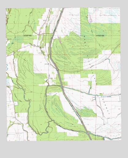
Bayou Jack, LA USGS Topographic Map
Click on map above to begin viewing in our Map Viewer.

This topographic map contains these locations and features:
Feature Name Type Latitude Longitude GNIS ID View Map
Alabama BayouStreamN30.8013°W91.9551°559757View Map
Apostolic CemeteryCemeteryN30.8330°W91.9612°552563View Map
Apostolic ChurchChurchN30.8330°W91.9615°559790View Map
Bayou Des Glaises Diversion ChannelCanalN30.7805°W91.9279°559938View Map
Bayou JackPopulated PlaceN30.8382°W91.9637°559982View Map
Bayou JackStreamN30.7694°W91.9501°559983View Map
Bayou Jack ChurchChurchN30.8224°W91.9537°559984View Map
Bayou TawpawStreamN30.7735°W91.9021°560087View Map
Black Water BayouStreamN30.8510°W91.9904°533192View Map
Cason CemeteryCemeteryN30.7721°W91.9904°560372View Map
Dunns LakeLakeN30.8422°W91.9940°560671View Map
Fish BayouStreamN30.7530°W91.8940°560743View Map
Horsehead BayouStreamN30.8002°W91.9854°561005View Map
Indian LakeLakeN30.8288°W91.9326°1627324View Map
Jims BayouStreamN30.8177°W91.9457°1627357View Map
Keller LakeLakeN30.7976°W91.9094°1627390View Map
McMillian BayouStreamN30.7724°W91.8937°1627633View Map
Montcrief Gas FieldOilfieldN30.8488°W91.8876°1629089View Map
Mount Olive CemeteryCemeteryN30.7769°W91.9907°552629View Map
Mount Olive ChurchChurchN30.7771°W91.9907°1627716View Map
North Bayou Jack Oil FieldOilfieldN30.8669°W91.9262°545558View Map
NugentPopulated PlaceN30.8632°W91.9562°543540View Map
Spring BayouStreamN30.7966°W91.9804°1628280View Map
Spring Bluff CemeteryCemeteryN30.8455°W91.9984°552683View Map
Spring Bluff ChurchChurchN30.8460°W91.9985°1628281View Map
TatervillePopulated PlaceN30.8071°W91.9540°1628333View Map
Telac BayouStreamN30.8352°W91.9971°1628341View Map
Trevassar BayouStreamN30.8435°W91.9815°1628380View Map
VeaziePopulated PlaceN30.7905°W91.9026°1628417View Map
Wards LakeLakeN30.8038°W91.9979°1628440View Map

Note: Coordinates in the location and feature list above are referenced to NAD83 datum.


Copyright (C) 2008-2024 Ryan Niemi / Sunset Dynamics ... All Rights Reserved