TopoQuest Logo
Do you find TopoQuest useful?
Help keep TopoQuest running and adding new maps/features by donating!
Bitcoin:  19c7KJd3qBynnjoSw5npx9KScwjBe4ifkT
Litecoin:  LXs6TkuXGGXo1vDsWCkWVdjQX94eUKd6ui
Home View Maps Find Maps Find Places Resources & Links


Palms, Michigan Topographic Map

USGS Map Title: Palms, MI
USGS Map MRC: 43082E7
DRG (GeoTIFF) Download: o43082e7.tif


Neighboring USGS Topographic Map Quads:


  Ubly, MI  
43082F8
 

  Minden City, MI  
43082F7
 

  Ruth, MI  
43082F6
 

  Argyle, MI  
43082E8
 

  Palms, MI  
43082E7
 

  Deckerville, MI  
43082E6
 

  Snover, MI  
43082D8
 

  Sandusky, MI  
43082D7
 

  Carsonville, MI  
43082D6


Map MRC Location:

N44°
W83°
N44°
W82°
H8 H7 H6 H5 H4 H3 H2 H1
G8 G7 G6 G5 G4 G3 G2 G1
F8 F7 F6 F5 F4 F3 F2 F1
E8 E7 E6 E5 E4 E3 E2 E1
D8 D7 D6 D5 D4 D3 D2 D1
C8 C7 C6 C5 C4 C3 C2 C1
B8 B7 B6 B5 B4 B3 B2 B1
A8 A7 A6 A5 A4 A3 A2 A1
N43°
W83°
N43°
W82°

Palms, MI USGS 1:24K Topographic Map Preview:
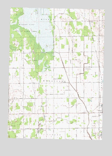
Palms, MI USGS Topographic Map
Click on map above to begin viewing in our Map Viewer.

This topographic map contains these locations and features:
Feature Name Type Latitude Longitude GNIS ID View Map
Banner Post Office (historical)Post OfficeN43.5389°W82.8250°2554392View Map
Bishop DrainCanalN43.5759°W82.7710°621455View Map
Brice DrainCanalN43.5025°W82.8652°621950View Map
Carrol DrainCanalN43.5447°W82.8010°622785View Map
Cedardale Post Office (historical)Post OfficeN43.6000°W82.7569°2554245View Map
Chevington Post Office (historical)Post OfficeN43.5514°W82.8403°2554391View Map
Deckerville StationLocaleN43.5267°W82.7506°2554129View Map
Doggan DrainCanalN43.6136°W82.7891°624745View Map
Downing CemeteryCemeteryN43.5156°W82.7572°624858View Map
Farnsworth GraveCemeteryN43.5333°W82.7944°2554470View Map
Flannigan DrainCanalN43.5231°W82.7547°626138View Map
Hewitt Carroll DrainCanalN43.5575°W82.8038°628172View Map
Hewitt DrainCanalN43.5795°W82.8585°628175View Map
McManus DrainCanalN43.5803°W82.7966°631990View Map
Minden City State Game AreaParkN43.6061°W82.8488°632445View Map
Monroe DrainCanalN43.5428°W82.8149°632578View Map
PalmsPopulated PlaceN43.6136°W82.7683°1617767View Map
Palms Post OfficePost OfficeN43.6136°W82.7683°2554205View Map
Palms StationLocaleN43.6139°W82.7697°2554398View Map
Pelton DrainStreamN43.5270°W82.7697°634574View Map
Pyette DrainCanalN43.5078°W82.7533°635534View Map
Richie DrainCanalN43.5572°W82.8360°635880View Map
Sandusky Jehovah's WitnessesChurchN43.5156°W82.8339°2554029View Map
Smith DrainCanalN43.5189°W82.7980°638144View Map
Terpinning DrainCanalN43.5664°W82.7644°1614684View Map
Thompson DrainCanalN43.5336°W82.7849°1614766View Map
Township of WheatlandCivilN43.5539°W82.8151°1627257View Map
Wheatland ChurchChurchN43.5531°W82.8402°1616256View Map
Wightman DrainCanalN43.5111°W82.8613°1616423View Map

Note: Coordinates in the location and feature list above are referenced to NAD83 datum.


Copyright (C) 2008-2025 Ryan Niemi / Sunset Dynamics ... All Rights Reserved