TopoQuest Logo
Do you find TopoQuest useful?
Help keep TopoQuest running and adding new maps/features by donating!
Bitcoin:  19c7KJd3qBynnjoSw5npx9KScwjBe4ifkT
Litecoin:  LXs6TkuXGGXo1vDsWCkWVdjQX94eUKd6ui
Home View Maps Find Maps Find Places Resources & Links


Scranton, Arkansas Topographic Map

USGS Map Title: Scranton, AR
USGS Map MRC: 35093C5
DRG (GeoTIFF) Download: o35093c5.tif


Neighboring USGS Topographic Map Quads:


  Coal Hill, AR  
35093D6
 

  Hartman, AR  
35093D5
 

  Clarksville, AR  
35093D4
 

  Paris, AR  
35093C6
 

  Scranton, AR  
35093C5
 

  New Blaine, AR  
35093C4
 

  Blue Mountain, AR  
35093B6
 

  Magazine Mountain NE, AR  
35093B5
 

  Chickalah Mountain West, AR  
35093B4


Map MRC Location:

N36°
W94°
N36°
W93°
H8 H7 H6 H5 H4 H3 H2 H1
G8 G7 G6 G5 G4 G3 G2 G1
F8 F7 F6 F5 F4 F3 F2 F1
E8 E7 E6 E5 E4 E3 E2 E1
D8 D7 D6 D5 D4 D3 D2 D1
C8 C7 C6 C5 C4 C3 C2 C1
B8 B7 B6 B5 B4 B3 B2 B1
A8 A7 A6 A5 A4 A3 A2 A1
N35°
W94°
N35°
W93°

Scranton, AR USGS 1:24K Topographic Map Preview:
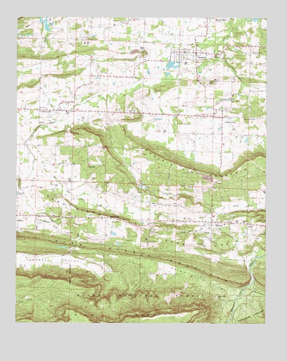
Scranton, AR USGS Topographic Map
Click on map above to begin viewing in our Map Viewer.

This topographic map contains these locations and features:
Feature Name Type Latitude Longitude GNIS ID View Map
Blair CemeteryCemeteryN35.3735°W93.5738°70709View Map
Butler CemeteryCemeteryN35.3048°W93.5716°79279View Map
City of ScrantonCivilN35.3606°W93.5390°2405435View Map
Crestview Baptist ChurchChurchN35.2904°W93.5077°79278View Map
East Fork Cane CreekStreamN35.3168°W93.6160°79284View Map
Ellsworth (historical)Populated PlaceN35.2909°W93.5582°64185View Map
Ellsworth CemeteryCemeteryN35.3076°W93.5643°71553View Map
Friendship Primitive Baptist ChurchChurchN35.3379°W93.6138°79281View Map
Guthrie CemeteryCemeteryN35.3348°W93.5440°71867View Map
Hickory Grove CemeteryCemeteryN35.2609°W93.5249°71989View Map
Horn CemeteryCemeteryN35.2823°W93.5346°72073View Map
Howard CemeteryCemeteryN35.2915°W93.5774°72096View Map
Liberty CemeteryCemeteryN35.2862°W93.6002°72322View Map
MidwayPopulated PlaceN35.2915°W93.5274°72645View Map
Midway Assembly of GodChurchN35.2909°W93.5294°79277View Map
Midway Rural Fire DepartmentBuildingN35.2919°W93.5274°2116796View Map
Missionary Baptist ChurchChurchN35.3368°W93.6135°79280View Map
Owens LakeReservoirN35.3660°W93.5813°80631View Map
Owens Lake DamDamN35.3668°W93.5802°80630View Map
PlainviewPopulated PlaceN35.3148°W93.5896°73116View Map
Pleasant Grove CemeteryCemeteryN35.3400°W93.6014°73128View Map
Pleasant HillPopulated PlaceN35.3373°W93.6141°78042View Map
Prairie ViewPopulated PlaceN35.3345°W93.5180°78094View Map
Prairie View Gas FieldOilfieldN35.3284°W93.5016°64188View Map
Prairie View MountainSummitN35.3104°W93.5194°73196View Map
Prairie View United Methodist ChurchChurchN35.3340°W93.5244°64169View Map
Rich MountainSummitN35.2520°W93.5671°73288View Map
Saint Ignatius CemeteryCemeteryN35.3591°W93.5264°73453View Map
Saint Louis ValleyValleyN35.2623°W93.5157°73455View Map
Saint Meinrads CemeteryCemeteryN35.3345°W93.5118°73456View Map
Sand RidgePopulated PlaceN35.2931°W93.5794°73474View Map
Sand RidgeRidgeN35.2862°W93.5638°73476View Map
ScrantonPopulated PlaceN35.3612°W93.5357°73503View Map
Scranton Elementary SchoolSchoolN35.3617°W93.5425°64186View Map
Scranton Fire Department Station 1BuildingN35.3595°W93.5363°2117100View Map
Scranton High SchoolSchoolN35.3613°W93.5411°64187View Map
Sorghum HollowValleyN35.2670°W93.5060°73641View Map
South Fork Pee Dee CreekStreamN35.2937°W93.5313°79283View Map
Stony Point CemeteryCemeteryN35.3609°W93.5080°73728View Map
Township of EllsworthCivilN35.2886°W93.5487°68795View Map
Township of LoganCivilN35.3383°W93.5277°68797View Map
West Fork Cane CreekStreamN35.2976°W93.6199°74063View Map
WilkinsPopulated PlaceN35.3306°W93.6141°79282View Map
Wright CemeteryCemeteryN35.2840°W93.5710°74216View Map

Note: Coordinates in the location and feature list above are referenced to NAD83 datum.


Copyright (C) 2008-2025 Ryan Niemi / Sunset Dynamics ... All Rights Reserved