TopoQuest Logo
Do you find TopoQuest useful?
Help keep TopoQuest running and adding new maps/features by donating!
Bitcoin:  19c7KJd3qBynnjoSw5npx9KScwjBe4ifkT
Litecoin:  LXs6TkuXGGXo1vDsWCkWVdjQX94eUKd6ui
Home View Maps Find Maps Find Places Resources & Links


Patterson, Georgia Topographic Map

USGS Map Title: Patterson, GA
USGS Map MRC: 31082D2
DRG (GeoTIFF) Download: o31082d2.tif


Neighboring USGS Topographic Map Quads:


  Coffee, GA  
31082E3
 

  K'Ville, GA  
31082E2
 

  Ritch, GA  
31082E1
 

  Mershon, GA  
31082D3
 

  Patterson, GA  
31082D2
 

  Screven, GA  
31082D1
 

  Blackshear West, GA  
31082C3
 

  Blackshear East, GA  
31082C2
 

  Patterson SE, GA  
31082C1


Map MRC Location:

N32°
W83°
N32°
W82°
H8 H7 H6 H5 H4 H3 H2 H1
G8 G7 G6 G5 G4 G3 G2 G1
F8 F7 F6 F5 F4 F3 F2 F1
E8 E7 E6 E5 E4 E3 E2 E1
D8 D7 D6 D5 D4 D3 D2 D1
C8 C7 C6 C5 C4 C3 C2 C1
B8 B7 B6 B5 B4 B3 B2 B1
A8 A7 A6 A5 A4 A3 A2 A1
N31°
W83°
N31°
W82°

Patterson, GA USGS 1:24K Topographic Map Preview:
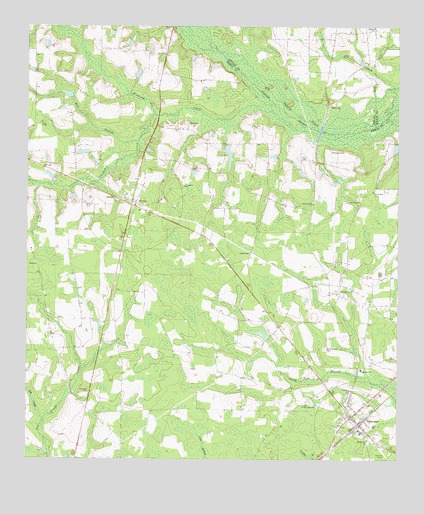
Patterson, GA USGS Topographic Map
Click on map above to begin viewing in our Map Viewer.

This topographic map contains these locations and features:
Feature Name Type Latitude Longitude GNIS ID View Map
Ashley CemeteryCemeteryN31.4719°W82.1737°310644View Map
AspinwallPopulated PlaceN31.4349°W82.1740°354406View Map
Aspinwall CemeteryCemeteryN31.4647°W82.1476°310649View Map
Bethlehem Primitive Baptist ChurchChurchN31.3808°W82.1346°354661View Map
Big CreekStreamN31.3869°W82.2443°311365View Map
Bird CemeteryCemeteryN31.4722°W82.1954°311443View Map
BristolPopulated PlaceN31.4485°W82.2146°354859View Map
Bristol Baptist ChurchChurchN31.4555°W82.2187°349050View Map
Bristol CemeteryCemeteryN31.4555°W82.2185°349051View Map
Church of the Living GodChurchN31.3908°W82.1571°312668View Map
City of PattersonCivilN31.3853°W82.1371°2404488View Map
County Line School (historical)SchoolN31.4994°W82.1329°350565View Map
Crooked CreekStreamN31.4669°W82.2123°313137View Map
Daystar StripAirportN31.3757°W82.1277°326827View Map
Evergreen ChurchChurchN31.4538°W82.1968°314009View Map
Fishing CreekStreamN31.4697°W82.1515°314150View Map
Full Gospel ChurchChurchN31.4524°W82.1335°314447View Map
Gethsemane CemeteryCemeteryN31.4072°W82.1490°314572View Map
Hopewell Church (historical)ChurchN31.4041°W82.2298°349069View Map
Lake Chapel Progressive Baptist ChurchChurchN31.4777°W82.1473°316532View Map
Lightsey Bridge (historical)BridgeN31.4999°W82.1965°349068View Map
Mill BranchStreamN31.4744°W82.2062°318177View Map
Mill Creek CemeteryCemeteryN31.4505°W82.1384°349073View Map
Mill Creek ChurchChurchN31.4505°W82.1376°318239View Map
Mill Creek School (historical)SchoolN31.4463°W82.1568°349074View Map
PattersonPopulated PlaceN31.3874°W82.1401°332619View Map
Patterson Assembly of God ChurchChurchN31.3817°W82.1471°2502344View Map
Patterson Baptist ChurchChurchN31.3869°W82.1390°349083View Map
Patterson City HallBuildingN31.3866°W82.1421°349084View Map
Patterson Elementary SchoolSchoolN31.3833°W82.1469°349085View Map
Patterson Fire DepartmentBuildingN31.3867°W82.1421°2603887View Map
Patterson Police DepartmentBuildingN31.3867°W82.1421°2733858View Map
Patterson SchoolSchoolN31.4010°W82.1371°320279View Map
Patterson Water Reclamation CenterLocaleN31.3849°W82.1269°2502462View Map
Pleasant Hill ChurchChurchN31.4488°W82.1535°320870View Map
Tyre BridgeBridgeN31.4697°W82.1510°349102View Map
Tyre CemeteryCemeteryN31.4619°W82.1573°324474View Map
Union ChapelChurchN31.4722°W82.2451°324495View Map
Winn School (historical)SchoolN31.4933°W82.2121°349106View Map
Worldwide Deliverance ChurchChurchN31.4526°W82.1332°2502345View Map
Youmans LakeReservoirN31.4633°W82.1820°342207View Map
Youmans Lake DamDamN31.4669°W82.1832°342206View Map

Note: Coordinates in the location and feature list above are referenced to NAD83 datum.


Copyright (C) 2008-2025 Ryan Niemi / Sunset Dynamics ... All Rights Reserved