TopoQuest Logo
Do you find TopoQuest useful?
Help keep TopoQuest running and adding new maps/features by donating!
Bitcoin:  19c7KJd3qBynnjoSw5npx9KScwjBe4ifkT
Litecoin:  LXs6TkuXGGXo1vDsWCkWVdjQX94eUKd6ui
Home View Maps Find Maps Find Places Resources & Links


Sargentville, Maine Topographic Map

USGS Map Title: Sargentville, ME
USGS Map MRC: 44068C6
DRG (GeoTIFF) Download: o44068c6.tif


Neighboring USGS Topographic Map Quads:


  Castine, ME  
44068D7
 

  Penobscot, ME  
44068D6
 

  Blue Hill, ME  
44068D5
 

  Cape Rosier, ME  
44068C7
 

  Sargentville, ME  
44068C6
 

  Brooklin, ME  
44068C5
 

  North Haven East, ME  
44068B7
 

  Deer Isle, ME  
44068B6
 

  Stinson Neck, ME  
44068B5


Map MRC Location:

N45°
W69°
N45°
W68°
H8 H7 H6 H5 H4 H3 H2 H1
G8 G7 G6 G5 G4 G3 G2 G1
F8 F7 F6 F5 F4 F3 F2 F1
E8 E7 E6 E5 E4 E3 E2 E1
D8 D7 D6 D5 D4 D3 D2 D1
C8 C7 C6 C5 C4 C3 C2 C1
B8 B7 B6 B5 B4 B3 B2 B1
A8 A7 A6 A5 A4 A3 A2 A1
N44°
W69°
N44°
W68°

Sargentville, ME USGS 1:24K Topographic Map Preview:
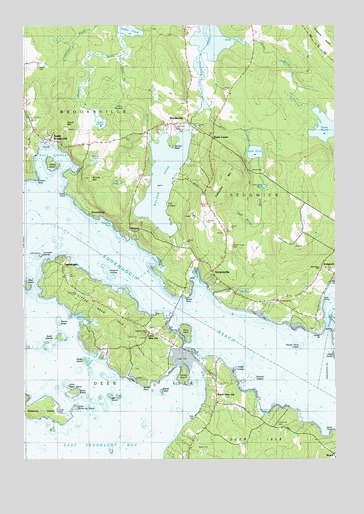
Sargentville, ME USGS Topographic Map
Click on map above to begin viewing in our Map Viewer.

This topographic map contains these locations and features:
Feature Name Type Latitude Longitude GNIS ID View Map
Bar IslandIslandN44.2684°W68.7153°561576View Map
Benjamin RiverStreamN44.2840°W68.6286°562047View Map
Billings BrookStreamN44.3415°W68.6992°562265View Map
Billings CoveBayN44.3020°W68.6806°562268View Map
Birch IslandIslandN44.3004°W68.7481°562315View Map
Black BrookStreamN44.3542°W68.6784°580754View Map
Black CornerPopulated PlaceN44.3429°W68.6739°579138View Map
Black PondLakeN44.3383°W68.6570°562495View Map
Blastow CoveBayN44.2804°W68.7203°562574View Map
BrooksvillePopulated PlaceN44.3467°W68.6836°563021View Map
Brooksville Free Public LibraryBuildingN44.3636°W68.7497°2738327View Map
Brooksville Volunteer Fire Department Main StationBuildingN44.3635°W68.7496°2552986View Map
Bucks HarborBayN44.3340°W68.7411°580903View Map
Byard PointCapeN44.2976°W68.6847°563325View Map
Carney IslandIslandN44.2740°W68.6853°563580View Map
Carter PointCapeN44.2867°W68.6317°563644View Map
Carters Point CemeteryCemeteryN44.2878°W68.6331°1911461View Map
Caterpillar MountainSummitN44.3303°W68.6685°563688View Map
Colossom LedgesBarN44.2734°W68.6592°580761View Map
Deadman CoveBayN44.3181°W68.7156°564899View Map
Deep Bridge BrookStreamN44.3367°W68.6559°580756View Map
Deer Island BridgeBridgeN44.2937°W68.6889°1911517View Map
Eastern CoveBayN44.2640°W68.7345°1911561View Map
Eastern PointCapeN44.2879°W68.6253°580764View Map
Eaton IslandIslandN44.2695°W68.7295°565756View Map
Eccemoccin ChurchChurchN44.2959°W68.6481°580765View Map
EggemogginPopulated PlaceN44.3062°W68.7336°565813View Map
Eggemoggin Christian AcademySchoolN44.2966°W68.6419°2737959View Map
Eggemoggin ReachChannelN44.2856°W68.6664°565814View Map
Forest Hill CemeteryCemeteryN44.2592°W68.6475°566386View Map
Forest Home CemeteryCemeteryN44.3117°W68.6664°566389View Map
Frost PondLakeN44.3452°W68.6282°566624View Map
Grays Hill CemeteryCemeteryN44.2981°W68.7280°567113View Map
Grays PointCapeN44.3273°W68.7320°567116View Map
Gull LedgesCliffN44.3223°W68.6920°567384View Map
Halftide RockBarN44.2717°W68.6895°580760View Map
Harbor IslandIslandN44.3348°W68.7386°567590View Map
Harbor LedgeBarN44.3376°W68.7370°581770View Map
HerricksPopulated PlaceN44.3154°W68.7061°579400View Map
Howard LedgesBarN44.3040°W68.7161°580757View Map
Howards Hill CemeteryCemeteryN44.2877°W68.6971°2740605View Map
Jerrys BrookStreamN44.3656°W68.7109°568812View Map
Jerrys MeadowSwampN44.3506°W68.7120°580755View Map
John Gray PondLakeN44.3286°W68.6532°568887View Map
Joyce PointCapeN44.2576°W68.6253°569014View Map
Kench MountainSummitN44.3462°W68.7331°569093View Map
Lakeview CemeteryCemeteryN44.3465°W68.6875°569325View Map
Lems CoveBayN44.3342°W68.7292°1912110View Map
Lily PondLakeN44.3298°W68.7112°569573View Map
Little Deer IsleIslandN44.2906°W68.7161°569744View Map
Little Deer IslePopulated PlaceN44.2865°W68.6959°569745View Map
Little Deer Isle Post OfficePost OfficeN44.2864°W68.6972°1911738View Map
Little Eaton IslandIslandN44.2712°W68.7334°569763View Map
Little Pickering IslandIslandN44.2654°W68.7289°569959View Map
Long CoveBayN44.2917°W68.7278°580698View Map
Meadow BrookStreamN44.3720°W68.7100°571046View Map
Mill PondLakeN44.2988°W68.6615°580406View Map
North Deer IslePopulated PlaceN44.2662°W68.6728°579562View Map
NorumbegaPopulated PlaceN44.3209°W68.7231°579580View Map
Number Three ChapelChurchN44.2954°W68.6470°572550View Map
Open Door SchoolSchoolN44.3051°W68.6311°580855View Map
Parker PondLakeN44.3738°W68.7074°572993View Map
Pickering IslandIslandN44.2645°W68.7417°573297View Map
Pumpkin IslandIslandN44.3092°W68.7431°573887View Map
Pumpkin Island Light Station (historical)BuildingN44.3092°W68.7423°1912111View Map
Punch BowlBayN44.3056°W68.6945°573896View Map
Round PondLakeN44.3358°W68.7210°574500View Map
SargentvillePopulated PlaceN44.3015°W68.6725°574928View Map
Sargentville Public LibraryBuildingN44.3007°W68.6697°2738472View Map
Saunders Memorial ChurchChurchN44.2867°W68.6997°574940View Map
Scott IslandsIslandN44.2854°W68.7359°575052View Map
Sedgwick Elementary SchoolSchoolN44.3601°W68.6643°1911931View Map
Sedgwick RidgeRidgeN44.3692°W68.6267°575223View Map
Sedgwick Town LandingLocaleN44.2959°W68.6297°1911933View Map
Sedgwick Volunteer Fire Department Sargentville StationBuildingN44.3124°W68.6681°2553113View Map
Sheep IslandIslandN44.2787°W68.7253°575345View Map
Snake PondLakeN44.3470°W68.7188°575666View Map
Snow BrookStreamN44.3695°W68.6606°580753View Map
Snow CoveBayN44.3698°W68.6661°575678View Map
South BrooksvillePopulated PlaceN44.3417°W68.7392°575825View Map
Spruce HeadCapeN44.3404°W68.6903°576132View Map
Stave IslandIslandN44.2867°W68.6845°576283View Map
Stump Cove LedgeBarN44.2831°W68.6384°580763View Map
Swains CoveBayN44.2898°W68.7259°576570View Map
Swains LedgeBarN44.2892°W68.7367°580758View Map
The TrianglesBarN44.3126°W68.7353°581945View Map
Thompson CoveBayN44.2642°W68.6534°577006View Map
Tinken LedgesBarN44.2762°W68.6656°580762View Map
Town of SedgwickCivilN44.3384°W68.6462°582721View Map
Walker PondReservoirN44.3303°W68.6936°577797View Map
Walker Pond DamDamN44.3448°W68.6834°1774579View Map
Weeds LedgeBarN44.2695°W68.6953°580759View Map
Weeds PointCapeN44.2709°W68.7011°578883View Map
Western CoveBayN44.2667°W68.7470°1912112View Map
Winche MountainSummitN44.3311°W68.7235°578561View Map
Wood CemeteryCemeteryN44.3635°W68.7436°564282View Map

Note: Coordinates in the location and feature list above are referenced to NAD83 datum.


Copyright (C) 2008-2024 Ryan Niemi / Sunset Dynamics ... All Rights Reserved