TopoQuest Logo
Do you find TopoQuest useful?
Help keep TopoQuest running and adding new maps/features by donating!
Bitcoin:  19c7KJd3qBynnjoSw5npx9KScwjBe4ifkT
Litecoin:  LXs6TkuXGGXo1vDsWCkWVdjQX94eUKd6ui
Home View Maps Find Maps Find Places Resources & Links


Linwood, Mississippi Topographic Map

USGS Map Title: Linwood, MS
USGS Map MRC: 32090G2
DRG (GeoTIFF) Download: o32090g2.tif


Neighboring USGS Topographic Map Quads:


  Eden, MS  
32090H3
 

  Zeiglerville, MS  
32090H2
 

  Ebenezer, MS  
32090H1
 

  Benton, MS  
32090G3
 

  Linwood, MS  
32090G2
 

  Vaughan, MS  
32090G1
 

  Bentonia, MS  
32090F3
 

  Berryville, MS  
32090F2
 

  Way, MS  
32090F1


Map MRC Location:

N33°
W91°
N33°
W90°
H8 H7 H6 H5 H4 H3 H2 H1
G8 G7 G6 G5 G4 G3 G2 G1
F8 F7 F6 F5 F4 F3 F2 F1
E8 E7 E6 E5 E4 E3 E2 E1
D8 D7 D6 D5 D4 D3 D2 D1
C8 C7 C6 C5 C4 C3 C2 C1
B8 B7 B6 B5 B4 B3 B2 B1
A8 A7 A6 A5 A4 A3 A2 A1
N32°
W91°
N32°
W90°

Linwood, MS USGS 1:24K Topographic Map Preview:
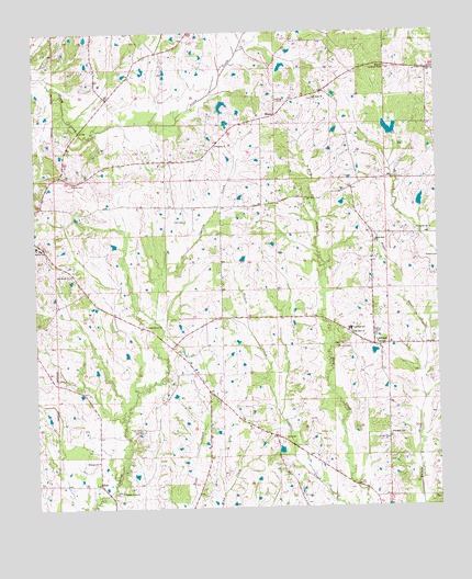
Linwood, MS USGS Topographic Map
Click on map above to begin viewing in our Map Viewer.

This topographic map contains these locations and features:
Feature Name Type Latitude Longitude GNIS ID View Map
Argyle Plantation (historical)LocaleN32.7585°W90.2306°707835View Map
Benton Elementary SchoolSchoolN32.8182°W90.2481°707840View Map
Benton High SchoolSchoolN32.8187°W90.2487°711552View Map
Black Jack ChurchChurchN32.8196°W90.1443°667224View Map
Blaylock CemeteryCemeteryN32.7690°W90.1404°667267View Map
Bull CemeteryCemeteryN32.7685°W90.1734°667769View Map
Campbell Lake DamDamN32.8318°W90.1834°681687View Map
Cedar Grove ChurchChurchN32.7979°W90.2156°668198View Map
Ebenezer ChurchChurchN32.7624°W90.2312°669648View Map
Ellison CemeteryCemeteryN32.7682°W90.1406°669739View Map
Ellison Creek Watershed 1 DamDamN32.8418°W90.1401°681694View Map
Ellison Creek Watershed Structure 4 DamDamN32.8251°W90.1334°681681View Map
EvansPopulated PlaceN32.8532°W90.1748°691850View Map
Heard CemeteryCemeteryN32.8154°W90.1287°671052View Map
Hearst Lake DamDamN32.8501°W90.1884°681701View Map
Hearst Lake DamDamN32.8568°W90.1901°692347View Map
Hicks CemeteryCemeteryN32.7712°W90.2181°671181View Map
LinwoodPopulated PlaceN32.7924°W90.1451°672518View Map
Linwood AirportAirportN32.7915°W90.1412°680354View Map
Linwood Elementary SchoolSchoolN32.7968°W90.1527°672523View Map
Luce CemeteryCemeteryN32.8254°W90.2029°672942View Map
Midway Lookout TowerTowerN32.8654°W90.1401°711276View Map
Mount Zion CemeteryCemeteryN32.7926°W90.1562°674317View Map
Mount Zion ChurchChurchN32.7957°W90.1515°674368View Map
NodPopulated PlaceN32.7565°W90.2306°692112View Map
Oak Grove ChurchChurchN32.8115°W90.2393°675043View Map
Pepper CreekStreamN32.7782°W90.1298°675606View Map
Pickett CemeteryCemeteryN32.8354°W90.2387°675707View Map
Plainsville ChurchChurchN32.8229°W90.1273°675953View Map
Saint James ChurchChurchN32.8576°W90.1629°677038View Map
Supervisor District 2CivilN32.8212°W90.1787°704466View Map
Swayze Lake DamDamN32.8685°W90.1584°681709View Map
Temple Love ChurchChurchN32.7546°W90.2243°678619View Map
Triunion ChurchChurchN32.8451°W90.1934°678891View Map
Union Paradise ChurchChurchN32.8646°W90.1262°679105View Map
Williams Estate Pond DamDamN32.8168°W90.2218°681673View Map

Note: Coordinates in the location and feature list above are referenced to NAD83 datum.


Copyright (C) 2008-2024 Ryan Niemi / Sunset Dynamics ... All Rights Reserved