TopoQuest Logo
Do you find TopoQuest useful?
Help keep TopoQuest running and adding new maps/features by donating!
Bitcoin:  19c7KJd3qBynnjoSw5npx9KScwjBe4ifkT
Litecoin:  LXs6TkuXGGXo1vDsWCkWVdjQX94eUKd6ui
Home View Maps Find Maps Find Places Resources & Links


Pine Level, Alabama Topographic Map

USGS Map Title: Pine Level, AL
USGS Map MRC: 32086A1
DRG (GeoTIFF) Download: o32086a1.tif


Neighboring USGS Topographic Map Quads:


  Davis Crossroads, AL  
32086B2
 

  Teasleys Mill, AL  
32086B1
 

  Fitzpatrick, AL  
32085B8
 

  Ramer, AL  
32086A2
 

  Pine Level, AL  
32086A1
 

  China Grove, AL  
32085A8
 

  Grady, AL  
31086H2
 

  Ansley, AL  
31086H1
 

  Needmore, AL  
31085H8


Map MRC Location:

N33°
W87°
N33°
W86°
H8 H7 H6 H5 H4 H3 H2 H1
G8 G7 G6 G5 G4 G3 G2 G1
F8 F7 F6 F5 F4 F3 F2 F1
E8 E7 E6 E5 E4 E3 E2 E1
D8 D7 D6 D5 D4 D3 D2 D1
C8 C7 C6 C5 C4 C3 C2 C1
B8 B7 B6 B5 B4 B3 B2 B1
A8 A7 A6 A5 A4 A3 A2 A1
N32°
W87°
N32°
W86°

Pine Level, AL USGS 1:24K Topographic Map Preview:
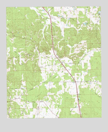
Pine Level, AL USGS Topographic Map
Click on map above to begin viewing in our Map Viewer.

This topographic map contains these locations and features:
Feature Name Type Latitude Longitude GNIS ID View Map
Bethesda ChurchChurchN32.0790°W86.0002°114103View Map
C E Sellers Number 3 DamDamN32.1201°W86.0033°130165View Map
C E Sellers Number 4 DamDamN32.1068°W86.0016°130150View Map
CurrysPopulated PlaceN32.0185°W86.0808°116980View Map
Frazer-McLeod CemeteryCemeteryN32.0715°W86.0963°118609View Map
Hills Chapel School (historical)SchoolN32.0188°W86.1202°142614View Map
I D McClurkin Number 1 DamDamN32.0718°W86.0700°130108View Map
I D McClurkin Number One LakeReservoirN32.0718°W86.0700°130109View Map
Jack Wool DamDamN32.1051°W86.0233°130144View Map
Lake BenReservoirN32.1049°W86.0203°113907View Map
Liberty ChurchChurchN32.0182°W86.0819°142668View Map
MacedoniaPopulated PlaceN32.0404°W86.0316°122139View Map
Macedonia ChurchChurchN32.0410°W86.0394°142679View Map
Mount Pleasant ChurchChurchN32.0263°W86.0313°152493View Map
Mount Zion ChurchChurchN32.0654°W86.0541°142739View Map
Pine LevelPopulated PlaceN32.0679°W86.0597°152926View Map
Pine Level ChurchChurchN32.0668°W86.0613°142794View Map
Pine Level DivisionCivilN32.0663°W86.0788°165908View Map
Pine Level Post OfficePost OfficeN32.0704°W86.0575°169044View Map
Possum Trot CemeteryCemeteryN32.1124°W86.0672°125197View Map
Rehoba Church (historical)ChurchN32.1049°W86.0283°142814View Map
Rehoba School (historical)SchoolN32.1046°W86.0300°142815View Map
Sellers Lake Number FourReservoirN32.1068°W86.0016°130149View Map
Sellers Lake Number ThreeReservoirN32.1201°W86.0033°130166View Map
Sellers PondsReservoirN32.1189°W86.0011°126540View Map
Spring Hill ChurchChurchN32.0788°W86.0872°127254View Map
Urquhart CemeteryCemeteryN32.0935°W86.1213°1934415View Map
Warrior Hill ChurchChurchN32.0788°W86.0638°153893View Map
WTSU-FM (Troy)TowerN32.0593°W86.0227°161148View Map

Note: Coordinates in the location and feature list above are referenced to NAD83 datum.


Copyright (C) 2008-2025 Ryan Niemi / Sunset Dynamics ... All Rights Reserved