TopoQuest Logo
Do you find TopoQuest useful?
Help keep TopoQuest running and adding new maps/features by donating!
Bitcoin:  19c7KJd3qBynnjoSw5npx9KScwjBe4ifkT
Litecoin:  LXs6TkuXGGXo1vDsWCkWVdjQX94eUKd6ui
Home View Maps Find Maps Find Places Resources & Links


Ramer, Alabama Topographic Map

USGS Map Title: Ramer, AL
USGS Map MRC: 32086A2
DRG (GeoTIFF) Download: o32086a2.tif


Neighboring USGS Topographic Map Quads:


  Snowdoun, AL  
32086B3
 

  Davis Crossroads, AL  
32086B2
 

  Teasleys Mill, AL  
32086B1
 

  Sellers, AL  
32086A3
 

  Ramer, AL  
32086A2
 

  Pine Level, AL  
32086A1
 

  Lapine, AL  
31086H3
 

  Grady, AL  
31086H2
 

  Ansley, AL  
31086H1


Map MRC Location:

N33°
W87°
N33°
W86°
H8 H7 H6 H5 H4 H3 H2 H1
G8 G7 G6 G5 G4 G3 G2 G1
F8 F7 F6 F5 F4 F3 F2 F1
E8 E7 E6 E5 E4 E3 E2 E1
D8 D7 D6 D5 D4 D3 D2 D1
C8 C7 C6 C5 C4 C3 C2 C1
B8 B7 B6 B5 B4 B3 B2 B1
A8 A7 A6 A5 A4 A3 A2 A1
N32°
W87°
N32°
W86°

Ramer, AL USGS 1:24K Topographic Map Preview:
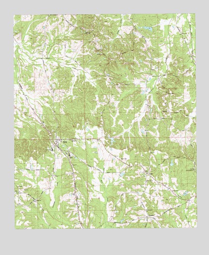
Ramer, AL USGS Topographic Map
Click on map above to begin viewing in our Map Viewer.

This topographic map contains these locations and features:
Feature Name Type Latitude Longitude GNIS ID View Map
Bob Thompson DamDamN32.1168°W86.1550°130160View Map
Bob Thompson LakeReservoirN32.1165°W86.1573°130159View Map
C E Neal DamDamN32.0201°W86.1366°130061View Map
C E Sellers DamDamN32.0535°W86.1816°130086View Map
C E Sellers LakeReservoirN32.0516°W86.1830°130085View Map
Chesser CemeteryCemeteryN32.1038°W86.1947°116012View Map
Church of ChristChurchN32.0218°W86.1419°116119View Map
Church of ChristChurchN32.0276°W86.1594°116120View Map
Dees LakeReservoirN32.0568°W86.1333°130093View Map
DublinPopulated PlaceN32.0321°W86.1591°155057View Map
Dunbar High SchoolSchoolN32.0429°W86.2125°117657View Map
Ebenezer ChurchChurchN32.0165°W86.2355°117820View Map
Evans DamDamN32.1151°W86.1550°130155View Map
Evans LakeReservoirN32.0792°W86.1611°142518View Map
Evans LakeReservoirN32.1151°W86.1550°130154View Map
Fannin DamDamN32.0351°W86.1400°130070View Map
FriendshipPopulated PlaceN32.0063°W86.1563°156382View Map
Friendship ChurchChurchN32.0107°W86.1597°118676View Map
Galilee ChurchChurchN32.0885°W86.1527°118784View Map
GibsonPopulated PlaceN32.0935°W86.1561°156404View Map
Hickory ChapelChurchN32.0788°W86.1450°120018View Map
Hills ChapelChurchN32.0340°W86.1252°120133View Map
Hills Chapel CemeteryCemeteryN32.0351°W86.1269°142613View Map
Lebanon Church (historical)ChurchN32.0960°W86.1550°142664View Map
MeadvillePopulated PlaceN32.0679°W86.1438°156693View Map
Mike Green Lookout TowerTowerN32.1149°W86.1989°164377View Map
Montgomery County High SchoolSchoolN32.0463°W86.2236°142707View Map
Montgomery County Sheriff's Office Ramer SubdivisionBuildingN32.0503°W86.2191°2752003View Map
Morris Dees DamDamN32.0568°W86.1333°130094View Map
Neal LakeReservoirN32.0201°W86.1366°130060View Map
Oak Wood School (historical)SchoolN32.1074°W86.2183°142766View Map
Pilgrims ChurchChurchN32.1132°W86.1344°124736View Map
RamerPopulated PlaceN32.0504°W86.2214°153107View Map
Ramer DivisionCivilN32.0475°W86.2351°165909View Map
Ramer Post OfficePost OfficeN32.0496°W86.2196°169054View Map
Rushing LakeReservoirN32.0351°W86.1400°130071View Map
Seek and Follow ChurchChurchN32.0335°W86.1263°126529View Map
Sentell CemeteryCemeteryN32.0199°W86.2083°126550View Map
South Montgomery County Volunteer Fire DepartmentBuildingN32.0364°W86.1672°2691439View Map
Stoddard (historical)LocaleN32.0126°W86.2316°142884View Map
Strickland DamDamN32.0301°W86.1750°130066View Map
Strickland LakeReservoirN32.0301°W86.1750°130067View Map
Weeping Mary ChurchChurchN32.0518°W86.2108°128703View Map

Note: Coordinates in the location and feature list above are referenced to NAD83 datum.


Copyright (C) 2008-2024 Ryan Niemi / Sunset Dynamics ... All Rights Reserved